Top Qs
Timeline
Chat
Perspective
Asakita-ku, Hiroshima
Ward of the city of Hiroshima, Japan From Wikipedia, the free encyclopedia
Remove ads
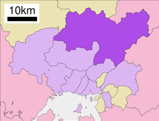
Asakita-ku (安佐北区) is one of the eight wards of the city of Hiroshima.

The northern portion contains what was Asa-gun and southern Takata-gun, now defunct districts (see Takata District, Hiroshima). Asa-gun consisted of Kabe-cho, Kōyō-cho, Asa-cho. Takata-gun included Shiraki-cho. After the four towns were merged with Hiroshima in 1973, they were designated a ward and named Asakita-ku.
As of April 1, 2006, the ward has an estimated population of 156,516 and a density of 442.95 persons per km2. The total area is 353.35 km2.
The Hiroshima Bunkyo Women's College is located in Asakita-ku.
Remove ads
Geography
Summarize
Perspective
Climate
Asakita-ku has a humid subtropical climate (Köppen climate classification Cfa) characterized by cool to mild winters and hot, humid summers. The average annual temperature in Asakita-ku is 14.9 °C (58.8 °F). The average annual rainfall is 1,678.3 mm (66.07 in) with July as the wettest month. The temperatures are highest on average in August, at around 27.0 °C (80.6 °F), and lowest in January, at around 3.5 °C (38.3 °F).[1] The highest temperature ever recorded in Asakita-ku was 38.9 °C (102.0 °F) on 16 July 1994; the coldest temperature ever recorded was −18.6 °C (−1.5 °F) on 27 February 1981.[2]
Demographics
Remove ads
References
Wikiwand - on
Seamless Wikipedia browsing. On steroids.
Remove ads
