Top Qs
Timeline
Chat
Perspective
Asaminami-ku, Hiroshima
Ward of Hiroshima in Chūgoku, Japan From Wikipedia, the free encyclopedia
Remove ads
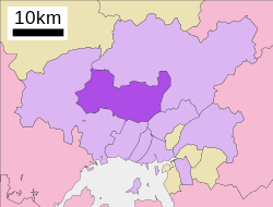
Asaminami-ku (安佐南区) is one of the eight wards of the city of Hiroshima, located in the south of former Asa District.
Remove ads
Merge
Asa District consisted of Gion-cho, Yasufuruichi-cho, Sato-cho, Numata-cho. After being merged with Hiroshima in 1973, this ward was named Asaminami-ku. The largest station of Astramline, a new traffic system, is in Asaminami-ku. This system brought population inflow.[citation needed]
Population
As of January 1, 2018, the ward has an estimated population of 245,475, with 101,941 households and a density of 2094 persons per km2. The total area is 117.24 km2.[2][1]
Transportation
JR-Kabe line
Astram line
Expressway
- San'yō Expressway
- Hiroshima IC
- Numata PA
- Hiroshima JCT
- Hiroshima Expressway (West Nippon Expressway Company)
- Hiroshimaseifushinto IC
- Hiroshima Expressway
- Numata IC
Industry
Hiroshima Mitsubishi Heavy Industries in Gion closed its doors in 2003.
Education
Agriculture
Former Sato-cho, now a part of the ward, has been a major production area for Hiroshimana since Meiji era. Hiroshimana is a variety of Chinese cabbage and is the main material used for making Hiroshimanazuke (literally "pickled Hiroshimana").[3][4][5]
Landslide
In August 2014 many people died in a landslide after very heavy rain.[6]
Footnotes
Wikiwand - on
Seamless Wikipedia browsing. On steroids.
Remove ads


