Top Qs
Timeline
Chat
Perspective
Bakkhali
Village in West Bengal, India From Wikipedia, the free encyclopedia

Remove ads
Bakkhali is a village within the jurisdiction of the Namkhana police station in the Namkhana CD block in the Kakdwip subdivision of the South 24 Parganas district in the Indian state of West Bengal.


Remove ads
History

Sir Andrew Fraser, Lieutenant Governor of Bengal (1903–1908) in the early twentieth century, is credited with "discovery" of the place. In recognition of his efforts, a part of the town is named Fraserganj. There is a dilapidated house near the beach, which according to the locals was the one in which Fraser used to stay.[3]
Remove ads
Geography
Summarize
Perspective

8km
5miles
5miles
B
a
y
o
f
B
e
n
g
a
l
N
Hooghly River
M
Sagar Island
R
Bakkhali
R
Harinbari
R
Ramganga
R
Ganespur
R
Gobardhanpur
R
Patharpratima
R
Gangasagar
R
Rudranagar
R
Fraserganj
R
Namkhana
R
Harwood Point
R
Kakdwip
Places in Kakdwip subdivision (Kakdwip, Sagar, Namkhana, Patharpratima CD blocks) in South 24 Parganas district
R: rural/ urban centre
Places linked with coastal activity are marked in blue
Owing to space constraints in the small map, the actual locations in a larger map may vary slightly
R: rural/ urban centre
Places linked with coastal activity are marked in blue
Owing to space constraints in the small map, the actual locations in a larger map may vary slightly
Area overview
Kakdwip subdivision has full rural population. The entire district is situated in the Ganges Delta. The southern part of the delta has numerous channels and islands such as Henry Island, Sagar Island, Frederick Island and Fraserganj Island. The subdivision is a part of the Sundarbans settlements. A comparatively recent country-wide development is the guarding of the coastal areas by special coastal forces. The area attracts large number of tourists – Gangasagar and Fraserganj-Bakkhali are worth mentioning. Gobardhanpur holds a promise for the future.[4][5][6]
Note: The map alongside presents some of the notable locations in the subdivision. All places marked in the map are linked in the larger full screen map.
Location
Bakkhali is located at 21°33′47″N 88°15′34″E. It has an average elevation of 4 metres (13 ft).
Remove ads
Activities
There is a fishing harbour at Frasergunj run by Benfish, a wing of the state government has a presence nearby.[7]
Tourism
 Sea beach in Bakkhali
 White Sea beach in Bakkhali
 Entrance to White Sand Beach
 White sand beach in Bakkhali
 White Sand Beach of Bakkhali
 White Sand Beach with wooden log in Bakkhali
 Way to White sand beach bakkhali
 Mangrove Reserve starting point in Bakkhali
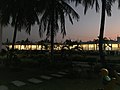 Resort in Bakkhali
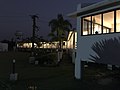 Resort view Bakkhali


Accessibility

Jambudwip and Lothian are two forested islands nearby. The only means of travel to the islands is by crude motorised country boat as there are no jetties in the islands. These islands are also places of tourist attraction nowadays.
Transport

Bakkhali lies on the National Highway 12, approximately 125 km from Kolkata.[8] Namkhana railway station is nearby.[8]
Healthcare
There is a primary health centre at Fraserganj, with ten beds.[9]
References
External links
Wikiwand - on
Seamless Wikipedia browsing. On steroids.
Remove ads