Top Qs
Timeline
Chat
Perspective
Barbourville, Kentucky
City in Kentucky, United States From Wikipedia, the free encyclopedia
Remove ads
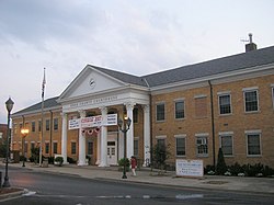
Barbourville is a home rule-class city in Knox County, Kentucky, in the United States. The population was 3,165 at the 2010 census,[5] down from 3,589 at the 2000 census. It is the county seat of Knox County.[6] The city was formally established by the state assembly in 1812.[7] It was incorporated in 1854 and then reincorporated in 1856.[8]
Union Commonwealth University and the Appalachian Children's Home are located in Barbourville.
Remove ads
Geography
Summarize
Perspective
Barbourville is in the center of Knox County, in the valley of the Cumberland River where it is joined by Richland Creek. U.S. Route 25E passes through the east side of the city, leading northwest 16 miles (26 km) to Corbin and southeast the same distance to Pineville.
According to the United States Census Bureau, the city has a total area of 2.68 square miles (6.95 km2), of which 2.62 square miles (6.79 km2) are land and 0.06 square miles (0.16 km2), or 2.35%, are water.[5]
Climate
Remove ads
Demographics
Summarize
Perspective

As of the census[13] of 2000, there were 3,165 people, 1,211 households, and 662 families residing in the city. The population density was 1,027.4 inhabitants per square mile (396.7/km2). There were 1,646 housing units at an average density of 471.2 per square mile (181.9/km2). The racial makeup of the city was 94.40% White, 3.23% African American, 0.56% Native American, 0.25% Asian, 0.17% from other races, and 1.39% from two or more races. Hispanic or Latino of any race were 0.59% of the population.
There were 1,211 households, out of which 24.9% had children under the age of 18 living with them, 36.9% were married couples living together, 19.6% had a female householder with no husband present, and 40.9% were non-families. 37.8% of all households were made up of individuals, and 15.4% had someone living alone who was 65 years of age or older. The average household size was 2.18 and the average family size was 2.88.
In the city, the population was spread out, with 22.1% under the age of 18, 15.7% from 18 to 24, 24.7% from 25 to 44, 20.5% from 45 to 64, and 17.0% who were 65 years of age or older. The median age was 34 years. For every 100 females, there were 82.2 males. For every 100 females age 18 and over, there were 78.4 males.
The median income for a household in the city was $13,297, and the median income for a family was $20,762. Males had a median income of $31,775 versus $18,102 for females. The per capita income for the city was $11,485. About 32.6% of families and 38.0% of the population were below the poverty line, including 43.4% of those under age 18 and 30.5% of those age 65 or over.
Remove ads
Arts and culture
Each year in early October, Barbourville hosts the Daniel Boone Festival, commemorating the pioneer who explored the area in 1775. The festival features open-air concerts, carnival attractions, a beauty pageant, a parade, and other events.[14]
Starting in 2005, the Southern and Eastern Kentucky Tourism Development Association began sponsoring the Springtime Redbud Festival. The first celebration was at Pine Mountain State Resort Park, 20 miles (32 km) south of Barbourville, but the celebration is now held on the campus of Union College (Kentucky). The Redbud Festival in April first featured a quilting workshop and now includes other traditions and crafts, including storytelling, art shows, dulcimer workshops, and a cooking school.[15]
Voters in Barbourville in 2015 approved alcohol sales in the city after 82 years of prohibition established by local law in 1933. The measure won in a special election in December 2015, by a little more than 60 votes. This approval came three and a half years after voters rejected alcohol sales in another special election. The measure will allow alcohol sales in both stores and restaurants.[16]
Education
Public schools
Public schools are administered by Knox County Public Schools.[17] Schools in Barbourville include:
- Central Elementary School
- G. R. Hampton Elementary School
- Jesse D. Lay Elementary School
- Knox County Middle School
- Knox Central High School
- Dewitt Elementary
- Girdler Elementary
- Flat Lick Elementary
- Lynn Camp Schools
Independent schools
The Barbourville Independent School District administers Barbourville Elementary School and Barbourville High School.[18]
Knox Appalachian School
The Knox Appalachian School is a public school serving the needs of the children committed to the Appalachian Children's Home.[19]
Public library
Barbourville has a lending library, the Knox County Public Library.[20]
Higher Education
Remove ads
Notable people
- Green Adams (1812–1884), United States congressman[21]
- George Madison Adams (December 20, 1837 – April 6, 1920), U.S. congressman (1867–1875), Clerk of the United States House of Representatives in the 44th, 45th, and 46th Congresses (1875–1881), Secretary of State of Kentucky (1887–1891)
- James D. Black (1849–1938), Kentucky governor (1919)
- James S. Golden, U.S. representative, 1949–1955
- Samuel Freeman Miller, U.S. Supreme Court justice
- John M. Robsion Jr., U.S. representative 1953–1959
- Flem D. Sampson, Kentucky governor (1927–1931)
- William A. Stanfill (1892–1971), U.S. senator (1945–1946)
- Kenneth H. Tuggle, Lt. Governor of Kentucky (1943–1947)
- Silas Woodson, Missouri governor
Remove ads
References
Further reading
External links
Wikiwand - on
Seamless Wikipedia browsing. On steroids.
Remove ads


