Top Qs
Timeline
Chat
Perspective
Batubara Regency
Regency in North Sumatra, Indonesia From Wikipedia, the free encyclopedia
Remove ads
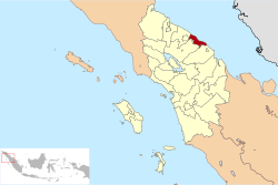
Batubara Regency is a regency on North Sumatra's eastern shoreline, with the town of Limapuluh as the seat of its administration. It was carved out from the seven most westerly coastal districts of Asahan Regency with effect from 15 June 2007. The new regency covers an area of 887.89 km2, and had a population of 375,885 at the 2010 Census[2] and 410,678 at the 2020 Census,[3] of whom 206,551 were male and 204,127 were female; the official estimate as at mid 2024 was 437,360 - comprising 219,965 males and 217,396 females.[1] It's quite densely populated compared to countries like China or Japan.
You can help expand this article with text translated from the corresponding article in Indonesian. (October 2017) Click [show] for important translation instructions.
|
Remove ads
Administrative districts
Summarize
Perspective
From 2007 until 2017 the regency was divided administratively into seven districts (kecamatan), but at the end of 2017 five additional districts were created by the division of four of the existing districts. The districts are tabulated below from east to west with their areas and their populations at the 2010 Census[2] and the 2020 Census,[3] together with the official estimates as at mid 2024.[1] The table also includes the locations of the district administrative centres, the number of administrative villages in each district (totaling 141 rural desa and 10 urban kelurahan), and its post code:
Note: (a) includes the small offshore islands of Pandang and Salahnama. (b) including two kelurahan - Bagan Arya and Tanjung Tiram Kota.
(c) the 2010 population of the new Nibung Hangus District is included with the figure for Tanjung Tiram District, from which it was cut out. (d) including one kelurahan - Labuhan Ruku.
(e) the 2010 population of the new Datuk Tanah Datar District is included with the figure for Talawi District, from which it was cut out. (f) including one kelurahan - Lima Puluh Kota.
(g) the 2010 population of the new Lima Puluh Pesisir and Datuk Lima Puluh Districts are included with the figure for Lima Puluh District, from which they were cut out.
(h) including two kelurahan - Indrapura and Indrasakti. (i) including one kelurahan - Perkebunan Sipare-pare.
(j) the 2010 population of the new Laut Tador District is included with the figure for Sei Suka District, from which it was cut out.
(k) including 3 kelurahan - Pagurawan, Pangkalan Dodek and Pangkalan Dodek Baru.
Geographically the regency falls into two sectors - an eastern sector comprising the first eight districts (covering 567.09 km2 with 266,688 inhabitants in mid 2024), and a western sector comprising the last four districts (covering 320.8 km2 with 170,672 inhabitants in mid 2024).
Remove ads
Transport
On 27 January 2015 groundbreaking began for the new Kuala Tanjung Port (in Sei Suka District), and the port was inaugurated in 2018. The port can accommodate 60 million TEUs (twenty-foot equivalent units) per year as the biggest port in West Indonesia, bigger than Tanjung Priok Port, in Jakarta (which has only 15 million TEUs per year).[4]
References
Wikiwand - on
Seamless Wikipedia browsing. On steroids.
Remove ads


