Top Qs
Timeline
Chat
Perspective
Bay of Fires
Bay in Tasmania, Australia From Wikipedia, the free encyclopedia
Remove ads
The Bay of Fires (palawa kani: larapuna)[1][2] is a bay on the northeastern coast of Tasmania in Australia, extending from Binalong Bay to Eddystone Point. The bay was given its name in 1773 by Captain Tobias Furneaux in Adventure,[3] who saw the fires of Aboriginal people on the beaches.

Bay whaling activities were carried out in the area in the 1840s.[4]
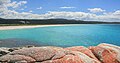
The Bay of Fires is a region of white beaches, blue water and orange-hued granite (the colour of which is actually produced by a lichen). The northern section of the bay is part of Mount William National Park; the southern end is a conservation area.[5]
A wide range of activities can be pursued in the Bay of Fires area, including camping, beach activities, boating, bird watching, fishing, swimming, surfing and walking.[6][7][8]
Remove ads
Tourism
In the 2000s, the Bay of Fires received several tourism accolades. In 2005, it was named as the world's second best beach by Condé Nast.[9] In 2008, it was named the world's "hottest" travel destination for 2009 by international guide book Lonely Planet.[10]

History
The Bay of Fires was a meeting place for Aboriginal family groups such as Panpe-kanner, Leener-rerter and Pinter-rairer.[11]
Pictures
 Binalong Bay Beach
 Beach and rocks


Wikimedia Commons has media related to Bay of Fires.
References
Wikiwand - on
Seamless Wikipedia browsing. On steroids.
Remove ads