Top Qs
Timeline
Chat
Perspective
Biggs site
Archaeological site in Kentucky, US From Wikipedia, the free encyclopedia

Remove ads
The Biggs Site (15Gp8), also known as the Portsmouth Earthworks Group D, is an Adena culture archaeological site located near South Shore in Greenup County, Kentucky. Biggs was originally a concentric circular embankment and ditch surrounding a central conical burial mound with a causeway crossing the ring and ditch. It was part of a larger complex, the Portsmouth Earthworks, located across the Ohio River and now mostly obliterated by agriculture and the developing city of Portsmouth, Ohio.[1][2]

Remove ads
Description
The site was surveyed and mapped by E. G. Squier in 1847 for inclusion in the seminal archaeological and anthrolopological work Ancient Monuments of the Mississippi Valley. They described the earthwork as being a causewayed embankment 5 feet (1.5 m) high by 30 feet (9.1 m) wide encircling a ditch 6 feet (1.8 m) deep and 25 feet (7.6 m) across. They encircled an area 90 feet (27 m) in diameter. In the center of the ditch was a conical tumulus 8 feet (2.4 m) high and 40 feet (12 m) in diameter.[3]
Remove ads
Gallery
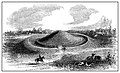 Squier and Davis illustration of the Biggs Site
 Squier and Davis map with Group D or the Biggs Site
 Scale aerial illustration of the Portsmouth Earthworks


See also
References
External links
Wikiwand - on
Seamless Wikipedia browsing. On steroids.
Remove ads