Top Qs
Timeline
Chat
Perspective
Boma, Democratic Republic of the Congo
Town in the Democratic Republic of the Congo From Wikipedia, the free encyclopedia

Remove ads
Boma is a port town on the Congo River, some 100 kilometres (62 mi) upstream from the Atlantic Ocean, in the Kongo Central Province of the Democratic Republic of the Congo (DRC), adjacent to the border with Angola. It had an estimated population of 162,521 in 2012.[2]
You can help expand this article with text translated from the corresponding article in French. (April 2024) Click [show] for important translation instructions.
|


_pg749_Panorama_du_nord_de_Boma.jpg)
Boma was the capital city of the Congo Free State and Belgian Congo (the modern Democratic Republic of the Congo) from 1 May 1886 to 1923, when the capital was moved to Léopoldville (since renamed Kinshasa). The port handles exports of tropical timber, bananas, cocoa, and palm products.
Remove ads
History
Boma was founded by European merchants in the 16th century as an entrepôt, including for the slave trade.[3] Trade was chiefly in the hands of Dutch merchants, but British, French and Portuguese firms also had factories there. No European power exercised sovereignty, though claims were from time to time put forward by Portugal.
British explorer Henry Morton Stanley arrived here on 9 August 1877, after crossing Africa from east to west.[4]
In 1884 the people of Boma were forced to grant a protectorate of their country to the International Association of the Congo, made up of European powers.[5] In 1886 King Leopold of Belgium established the Congo Free State, designating Boma as its capital. He ran the state as his personal fiefdom for several years, nearly enslaving many Congolese with a private military, and abusing them to force rubber production. International outrage and action by the Belgian legislature resulted in the government taking over supervision of what was established as the colony of the Belgian Congo in 1908.
Boma continued as the capital of the Belgian Congo until 1923.[6] Léopoldville, since renamed as Kinshasa, was designated as the new capital.
Remove ads
Transport
Boma lies on the north bank of the Congo River, some 100 km upstream from Muanda, where the river flows into the Atlantic Ocean. The great width and depth of the river allow seagoing ships to reach Boma, which is the second-largest port of DR Congo, after Matadi. Between 1889 and 1984, the port was served by the Mayumbe line from Tshela. The line was initially built as 610 mm (24 inch) gauge in 1889 before being converted to 600 mm in 1932.
Remove ads
Notable people
- Antoine-Roger Bolamba (1913–2002), politician and poet[7]
- Claude Kiambe (born 2003), singer-songwriter
Climate
Summarize
Perspective
Köppen-Geiger climate classification system classifies its climate as tropical wet and dry (Aw).
The highest record temperature was 41 °C (106 °F) on February 25, 1976, while the lowest record temperature was 10 °C (50 °F) on October 21, 1976.[8]
Remove ads
Gallery
 Boma pier, 1899
 Authorities at the end of the pier, Boma, 1899
 The nine old kings of Boma (phot. H. A. Shanu, 1898), Royal Museum for Central Africa
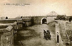 Fort de Shinkakasa – fortification on the Congo River near Boma
 Church of Boma, which still exists; oldest in the country
 Residence of the Governor-General in Boma
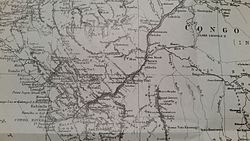 Henry Morton Stanley's map of the area during his expedition down the Congo River
 Church of Boma, January 2007


Remove ads
See also
References
External links
Wikiwand - on
Seamless Wikipedia browsing. On steroids.
Remove ads