Top Qs
Timeline
Chat
Perspective
Boven-Leeuwen
Village in Gelderland, Netherlands From Wikipedia, the free encyclopedia

Remove ads
Boven-Leeuwen is a village in the Dutch province of Gelderland. It is a part of the municipality of West Maas en Waal, and lies about 9 km east of Tiel. It is the protestant part of the former village of Leeuwen.


Remove ads
History
It was first called Boven-Leeuwen in 1986 to distinguish from Beneden-Leeuwen.[3] Leeuwen was first attested in the 12th century as Lewen, and means "settlement near burial hill".[4] The village developed along the Waal. In 1898, a Catholic church was built in Beneden-Leeuwen, and the village split in a Catholic (beneden) and a Protestant (boven) village.[5]
The Dutch Reformed church was built between 1753 and 1756.[5] It was severely damaged in 1944/1945, and restored between 1964 and 1966.[6] In 1918, a Catholic church was constructed in Boven-Leeuwen. Huis te Leeuwen is a manor house which was built in 1654 as an extension of a medieval house. In 1819, the estate was demolished except for the gate house and the moat.[5] In 1840, the entire village of Leeuwen was home to 2,128 people.[6]
Remove ads
People born in Boven-Leeuwen
- Airco Caravan (born 1965), artist
Gallery
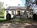 Huis te Leeuwen
 Farm in Boven-Leeuwen
 Catholic church
 Dutch Reformed church


References
Wikiwand - on
Seamless Wikipedia browsing. On steroids.
Remove ads