Top Qs
Timeline
Chat
Perspective
Buni
Pakistani town From Wikipedia, the free encyclopedia
Remove ads
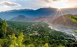
Buni (Khowar, Urdu: بونی; also spelled Booni) is a town and the headquarters of Upper Chitral District in Khyber Pakhtunkhwa, Pakistan.[1][2] The 2,500 m (8,200 ft) high Qaqlasht Meadows, which host a major festival in the region, are situated near the town.[3]
This article has multiple issues. Please help improve it or discuss these issues on the talk page. (Learn how and when to remove these messages)
|
Lying near the foothills of the Buni Zom, Buni is located in proximity to glacial lakes due to which the town has faced floodings various times.[2] Through the glacial melting followed by heavy monsoon rainfalls, the region was severely affected by the floods during August 2024.[4][5]
Remove ads
Demography
The residents of Buni are primarily Kho people (also known as Chitralis), who speak Khowar, a language widely spoken and understood throughout the Chitral region. Urdu, the national language of Pakistan, is also commonly spoken and understood. The population comprises both Ismaili and Sunni Muslims.[citation needed]
Climate
The climate is considered to be a local Mediterranean climate. During the year, there is abundant rainfall. This climate is considered to be Csa to the Köppen-Geiger climate classification. The average annual temperature in Buni is 15.6 °C. About 418 mm of precipitation falls annually.
Remove ads
Educational institutions
There are a number of educational institutions in Booni,[citation needed] which includes;
- Aga Khan High School
- FCPS[clarification needed]
- Government Degree College
- Government High School
- Government Girls Degree College
- Nani ECD School Lasht
- Oxford Public School
- Pamir School and College
- Space Era Model School
See also
References
External links
Wikiwand - on
Seamless Wikipedia browsing. On steroids.
Remove ads


