Top Qs
Timeline
Chat
Perspective
California's 41st congressional district
U.S. House district for California From Wikipedia, the free encyclopedia

Remove ads
California's 41st congressional district is a congressional district in Riverside County, in the U.S. state of California. The district is currently represented by Republican Ken Calvert.
.svg)

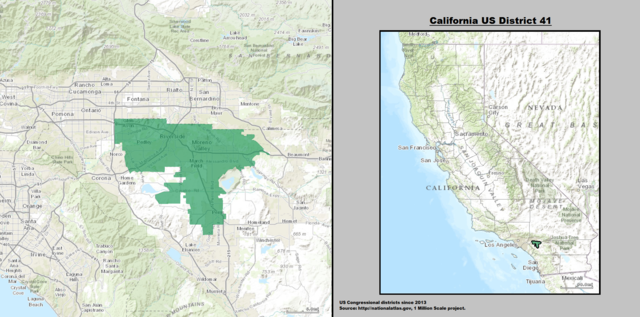
The 41st district currently includes most of the wealthy, majority-white parts of the Coachella Valley, including the cities of Palm Springs, Rancho Mirage, Palm Desert, Indian Wells, and La Quinta. The district then stretches through the sparsely inhabited regions of the San Jacinto Mountains before taking in the vast majority of Corona and its sphere of influence, including Norco, Lake Elsinore, Canyon Lake, and portions of Eastvale. The edges of the district also stretch further south to take in portions of the Perris and Temecula Valleys, such as Menifee, Wildomar, and small portions of Murrieta. The representative for the 41st is Ken Calvert, who was redistricted from the 42nd district.
The district is considered a swing seat, and the 2024 race was rated as a "Toss Up" by the Cook Political Report, although a Democrat has not won election in this seat since redistricting.[3]
Remove ads
Recent election results from statewide races
Remove ads
Composition
Summarize
Perspective
Under the 2020 redistricting, California's 41st congressional district is located entirely in western Riverside County, in the Inland Empire of Southern California. It includes the cities of Wildomar, Canyon Lake, Menifee, Palm Springs, Palm Desert, La Quinta, Lake Elsinore, Norco, Calimesa, Rancho Mirage, Indian Wells, most of Corona, southern Eastvale, and western Riverside; and the census-designated places Cherry Valley, Nuevo, Homeland, Sage, Idyllwild-Pine Cove, Woodcrest, Coronita, El Sobrante, El Cerrito, Lake Mathews, Temescal Valley, Warm Springs, Lakeland Village, Lakeview, Romoland, Green Acres, French Valley, Anza, and Mountain Center.
Riverside County is split between this district, the 25th district, the 39th district, and the 48th district. The 41st and 25th are partitioned by Terwillinger Rd, Bailey Rd, Candelaria, Elder Creek Rd, Bonny Ln, Tule Peak Rd, Eastgate Trail, Goldrush Rd, Rule Valley Rd, Laura Ln, Dove Dr, Lago Grande, Barbara Trail, Valley Dr, Foolish Pleasure Rd, Highway 371, Gelding Way, Puckit Dr, Indian Rd, Wellman Rd, El Toro Rd, Burnt Valley Rd, Cahuilla Rd, Highway 74, Bull Canyon Rd, Santa Rosa-San Jacinto Mountains National Monument, Fred Waring Dr, Washington St, Highway 10, Davall Dr, Dinah Shore Dr, Plumley Rd, Gerald Ford Dr, E Ramon Rd, San Luis Rey Dr, San Joaquin Dr, Clubhouse View Dr, Mount San Jacinto State Park, Azalea Creek, Black Mountain Trail, Highway 243, North Fork San Jacinto River, Stetson Ave, Hemet St, Cornell St, Girard St, E Newport Rd, Domenigoni Parkway, Leon Rd, Grand Ave, State Highway 74, California Ave, W Devonshire Ave, Warren Rd, Ramona Expressway, San Jacinto River, Highway 79, Oak Valley Parkway, Champions Dr, Union St, Brookside Ave.
The 41st and 39th are partitioned by Corona Freeway, River Trails Park, Redley Substation Rd, Arlington Ave, Alhambra Ave, Golden Ave, Doheny Blvd, Bolivar St, Campbell Ave, Pierce St, Quantico Dr, Collett Ave, Buchanan St, Highway 91, 12397 Doherty Way-Magnolia Ave, BNSF Railroad, N McKinley St, N Temescal St, E 16th St, S Neece St, Indiana Ave, Skyridge Dr, Fillmore St, 2969 Fillmore St-La Sierra Ave, Cleveland Ave, McAllister Parkway, Corsica Ave, Hermosa Dr, John F. Kennedy Dr, Wood Rd, Colt St, Dauchy Ave, Van Buren Blvd, Bobbit Ave, Chicago Ave, Krameria Ave, 16510 Sendero del Charro-Mariposa Ave, Barton St, Cole Ave, Rider St, Greenwood Ave, Kabian Park, Goetz Park, Ethanac Rd, McLaughlin Rd, Sherman Rd, Tumble Rd, Watson Rd, Escondido Expressway, Mapes Rd, Ellis Ave, Antelope Rd, Rico Ave, San Jacinto River, Ramona Expressway, Lake Perris State Recreation Area, Gilman Springs Rd, Moreno Valley Freeway, Quincy St, Cloud Haven Dr, Holly Ct, Reche Vista Dr, Reche Canyon Rd, and Keissel Rd.
The 41st and 48th are partitioned by Ortega Highway, Tenaja Truck Trail, NF-7506, Tenaja, San Mateo Creek, Los Alamos Rd, Und 233, S Main Dv, Wildomar, Grand Ave, Rancho Mirlo Dr, Copper Canyon Park, 42174 Kimberly Way-35817 Darcy Pl, Escondido Expressway, Scott Rd, 33477 Little Reb Pl-33516 Pittman Ln, Keller Rd, Menifee Rd, Clinton Keith Rd, Max Gilliss Blvd, Highway 79, Borel Rd, Lake Skinner, Warren Rd, Summitville St, Indian Knoll Rd, E Benton Rd, Rancho California Rd, Overhill Rd, Green Meadow Rd, Crossover Rd, Exa-Ely Rd, Denise Rd, Wiley Rd, Powerline Rd, Wilson Valley Rd, Wilson Creek, Reed Valley Rd, Centennial St, Beaver Ave, and Lake Vista Dr.
Cities and CDPs with 10,000 or more people
- Riverside – 317,261
- Corona – 157,136
- Menifee – 109,399
- Lake Elsinore – 71,898
- Eastvale – 69,757
- Palm Desert – 51,583
- Palm Springs – 44,575
- La Quinta – 41,748
- Wildomar – 37,214
- French Valley – 35,280
- Norco – 26,316
- Temescal Valley – 26,232
- Rancho Mirage – 17,633
- Woodcrest – 15,378
- El Sobrante – 14,039
- Lakeland Village – 12,364
- Canyon Lake - 11,142
- Calimesa – 10,026
2,500 – 10,000 people
- Nuevo – 7,033
- Homeland – 6,772
- Cherry Valley – 6,509
- Nuevo – 6,447
- Lake Mathews – 5,972
- El Cerrito – 5,058
- Indian Wells – 4,757
- Idyllwild-Pine Cove – 4,163
- Sage – 3,370
- Anza – 3,075
- Idyllwild-Pine Cove – 2,963
- Green Acres – 2,918
- Coronita – 2,639
Remove ads
List of members representing the district

.jpg)


_(new_version).svg)
Remove ads
Election results
Summarize
Perspective
|
1972 • 1974 • 1976 • 1978 • 1980 • 1982 • 1984 • 1986 • 1988 • 1990 • 1992 • 1994 • 1996 • 1998 • 2000 • 2002 • 2004 • 2006 • 2008 • 2010 • 2012 • 2014 • 2016 • 2018 • 2020 • 2022 • 2024 |
1972
1974
1976
1978
1980
1982
1984
1986
1988
1990
1992
1994
1996
1998
2000
2002
2004
2006
2008
2010
2012
2014
2016
2018
2020
2022
2024
Remove ads
Historical district boundaries
San Diego County
In the 1980s, the 41st congressional district was one of four that divided San Diego County, formerly located in the North County region. The district had been held for 12 years by Republican Bill Lowery and was considered the most Republican district in the San Diego area. The 41st district was renumbered as the California's 51st congressional district after the 1990 U.S. census in which it became the Inland Empire's 51st.
San Bernardino County
From 2003 to 2013, the district included large portions of the cavernous San Bernardino County and a small portion of Riverside County. The district formerly represented parts of the Inland Empire region, San Bernardino Mountains, and Mojave Desert, stretching from portions of the city of San Bernardino north to the Nevada border and east to the Colorado River. Redlands was the largest city in that district; other cities included: Loma Linda, Yucaipa, Victorville, Barstow, Hesperia, Highland, Big Bear Lake and Needles.
Remove ads
See also
References
External links
Wikiwand - on
Seamless Wikipedia browsing. On steroids.
Remove ads