Top Qs
Timeline
Chat
Perspective
Camelot (crater)
Lunar impact crater From Wikipedia, the free encyclopedia
Remove ads
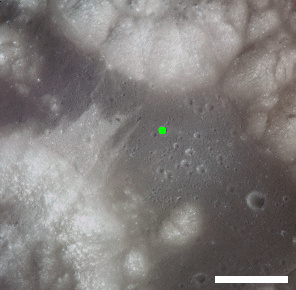
Camelot is a feature on Earth's Moon, a crater in Taurus-Littrow valley. Astronauts Eugene Cernan and Harrison Schmitt visited it in 1972, on the Apollo 17 mission, during EVA 2. Geology Station 5 was along the south rim of Camelot.
Camelot is due 700 meters west of the landing site. The smaller Horatio crater is to the southwest, and Victory is to the northwest. Powell and Trident are to the southeast.
The crater was named by the astronauts after the castle Camelot of Arthurian legend.[2]


Remove ads
Samples
The following samples were collected from Camelot crater (Station 5), as listed in Table 7-I of the Apollo 17 Preliminary Science Report.[3] The "Rock Type" is from the table, and the "Lithology" is from the Lunar Sample Compendium of the Lunar and Planetary Institute or NASA's Lunar Sample Catalog.
| Sample | In Situ Photo | Rock Type | Lithology | Photo |
| 75015 |  | Coarse basalt | Ilmenite Basalt[4] | |
| 75035 |  | Medium basalt | Ilmenite Basalt[5] | |
| 75055 |  | Coarse basalt | Ilmenite Basalt[6] |  |
| 75065 | - | Medium basalt | High-Ti Mare Basalt[7] | - |
| 75066 | - | Dark-gray basalt | Glassy Breccia[8] | - |
| 75075 |  | Medium basalt | Vuggy Ilmenite Basalt[9] | |
| 75085 | - | Medium basalt | High-Ti Basalt (from soil sample 75080)[10] | - |
| 75086 | - | Medium basalt | High-Ti Basalt (from soil sample 75080)[11] | - |
| 75087 | - | Medium basalt | High-Ti Basalt (from soil sample 75080)[12] | - |
| 75088 | - | Fine basalt | High-Ti Basalt (from soil sample 75080)[13] | - |
| 75089 | - | Fine basalt | High-Ti Basalt (from soil sample 75080)[14] | - |
| 75115 | - | Fine basalt | High-Ti Basalt | - |
Remove ads
References
External links
Wikiwand - on
Seamless Wikipedia browsing. On steroids.
Remove ads

