Top Qs
Timeline
Chat
Perspective
Ciletuh-Palabuhanratu Geopark
From Wikipedia, the free encyclopedia
Remove ads
Ciletuh-Palabuhanratu Geopark (Indonesian: Taman Bumi Ciletuh-Palabuhanratu) is a national Geopark at Pelabuhan Ratu in Sukabumi Regency in West Java, Indonesia. It was recognized by UNESCO in 2015 as a national geopark, and it was proposed to become a member of the Global Geopark Network (GGN) to be recognized by UNESCO by 2017, but UNESCO finally made the park a part of the Global Geoparks Network in April 2018.[2]
The park has a land area of about 128,000 hectares, spread over 8 districts and 74 villages of Sukabumi Regency.
Remove ads
Attractions
The park is a popular tourist destination.[3] Attractions of which are:
- Puncak Darma-It is the highest point of the park.
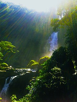
- Curug Sodong-waterfall
- Curug Awang-Waterfall
- Palangpang Beach
- Bukit Panenjoan-hill
- Curug Cimarinjung-waterfall
- Palabuhanratu Beach
- Lalay Cave Palabuhanratu
- Palabuhanratu Thermal Baths
See also
References
Wikiwand - on
Seamless Wikipedia browsing. On steroids.
Remove ads


