Top Qs
Timeline
Chat
Perspective
Circum Peak
Mountain in the Falkland Islands From Wikipedia, the free encyclopedia
Remove ads
Circum Peak is a hill rising to 198 m (650 ft)[1] in the southeast part of Weddell Island in the Falkland Islands. It is located at 51°55′45″S 60°55′27″W, which is 2.12 km (1.32 mi) southeast of Mount Weddell, and surmounts New Year Cove to the southeast and Gull Harbour to the northeast.

Remove ads
Maps


- The Falkland Islands. Scale 1:401280 map. London: Edward Stanford, 1901
- Falkland Islands Explorer Map. Scale 1:365000. Ocean Explorer Maps, 2007
- Falklands Topographic Map Series. Scale 1:50000, 29 sheets. DOS 453, 1961-1979
- Falkland Islands. Scale 1:643000 Map. DOS 906. Edition 3-OS, 1998
- Approaches to the Falkland Islands. Scale 1:1500000 chart. Gps Nautical Charts, 2010
- Illustrated Map of Weddell Island
Remove ads
Gallery
 Massive stone runs in the foothills of Circum Peak; southeast view from Mount Weddell
 Old map of Weddell Island featuring Cove Peak (present Circum Peak)
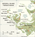 Map of Weddell Island


Notes
References
External links
Wikiwand - on
Seamless Wikipedia browsing. On steroids.
Remove ads