Top Qs
Timeline
Chat
Perspective
City of South Melbourne
Local government area in Victoria, Australia From Wikipedia, the free encyclopedia

Remove ads
The City of South Melbourne was a local government area about 2 kilometres (1.2 mi) south of Melbourne, the state capital of Victoria, Australia, on the south bank of the Yarra River. The city covered an area of 8.91 square kilometres (3.44 sq mi), and existed from 1855 until 1994.

The council area was bounded by the Yarra River to the north, Fraser and Lorne Streets to the south, the Port Phillip foreshore and Pickles Street to the west, and St Kilda Road to the east.[2]
Remove ads
History
South Melbourne was first incorporated as the Emerald Hill Borough on 26 May 1855, and became a town on 1 March 1872. It was proclaimed a city, and was renamed South Melbourne, on 21 September 1883.[2]
On 18 November 1993, a small portion around Southbank and the Victorian Arts Centre was annexed to the City of Melbourne.[3]
On 22 June 1994, the City of South Melbourne was abolished, and along with the Cities of Port Melbourne and St Kilda, was merged into the newly created City of Port Phillip.[4]
The council met at the South Melbourne Town Hall on Bank Street, between Fishley and Layfield Streets, South Melbourne. The hall still exists and is now used by the Australian National Academy of Music.
Remove ads
Suburbs
- Albert Park
- Melbourne (between Queens Road and St Kilda Road)
- Middle Park
- Southbank
- South Melbourne*
* Council seat.
Population
* Estimate in the 1958 Victorian Year Book.
Councillors
Summarize
Perspective
The City of South Melbourne was divided into four wards, each electing three councillors:
- Canterbury Ward
- Fawkner Ward
- Hobson Ward
- Queens Ward
List of known councillors
† = Died in office
Remove ads
Gallery
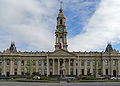 South Melbourne Town Hall

References
External links
Wikiwand - on
Seamless Wikipedia browsing. On steroids.
Remove ads