Top Qs
Timeline
Chat
Perspective
Culpeper Basin
Triassic rift basin in the United States From Wikipedia, the free encyclopedia

Remove ads
The Culpeper Basin is one of the Newark Supergroup's Triassic rift basins.[1] Its formation is tied to the initial rifting of the supercontinent Pangea. Volcanism associated with the Culpeper basin was part of a much larger event known as the Central Atlantic magmatic province (CAMP); one of the largest flood basalt eruptions in Earth's history.[2] It lies east of the Appalachian Mountains and extends from the Madison County—Orange County line in Virginia to Frederick, Maryland.[3] A diverse group of sedimentary rocks including siltstone, sandstone, and conglomerate within the basin were intruded by igneous rocks (primarily diabase), which caused thermal metamorphism at the contact with sedimentary rock.[4]
_1983.png)
link to publication.
The Culpeper Basin is nearly continuous with the Gettysburg Basin to the north and with the Barboursville Basin to the south.
The Groveton Member of the Bull Run Formation is exposed there.[1] The formation has produced disarticulated fish remains including isolated bones and scales.[1]
Each Sedimentary formation has large basaltic lava flows associated with the initial rifting of Pangea. These are broken up into three pulses:
Mount Zion Church Basalt: This was the first eruption during CAMP volcanism.[5]
Hickory Grove Basalt: This was the second outpouring of basaltic lava during the CAMP eruptions.[6]
Sanders Basalt: This was the final pulse of volcanic activity in the Culpeper Basin.
The large body of diabase in central Montgomery County, Maryland, is known as the Boyds Sill,[7] named after the town of Boyds.
 Jurassic diabase boulders in the Culpeper Basin northeast of Dulles Airport
 Balls Bluff Siltstone with diabase intrusion, northern face of Luck Stone Quarry, Manassas
 Limestone conglomerate of Leesburg Member
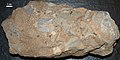 Another sample of limestone conglomerate
 Sandstone from southwest the Boyds Sill in Montgomery County, Maryland
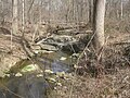 Unnamed stream exposing diabase of Boyds Sill, Hoyles Mill Trail, Montgomery County, Maryland

.jpg)
.jpg)


Remove ads
Footnotes
References
Wikiwand - on
Seamless Wikipedia browsing. On steroids.
Remove ads