Top Qs
Timeline
Chat
Perspective
Dayr al-Hawa
Place in Jerusalem, Mandatory Palestine From Wikipedia, the free encyclopedia

Remove ads
Dayr al-Hawa (Arabic: دير الهوا) was a Palestinian Arab village in the Jerusalem Subdistrict. The village was depopulated during the 1948 Arab-Israeli War on October 19, 1948, by the Fourth Battalion of the Har'el Brigade of Operation ha-Har. It was located 18.5 km west of Jerusalem.
.jpg)
.jpg)
.jpg)
.jpg)

Remove ads
History
Summarize
Perspective
Ottoman era
Dayr al-Hawa is not mentioned in 16th century records, and was likely first settled in a later period.[6]
In 1838, Edward Robinson called it a "lofty" village, on the brink of a valley.[7] It was further noted as a Muslim village, located in the District of el-Arkub, southwest of Jerusalem.[8] In 1856 the village was named D. el Hawa on Kiepert's map of Palestine published that year.[9]
Victor Guérin, visiting the village in 1863, wrote that Dayr al-Hawa "probably owes its name, monastery of the wind, to its high position".[10]
An Ottoman village list from around 1870 showed that Der el-Hawa had 32 houses and a population of 103, though the population count included men, only.[11][12]
In 1883, the PEF's Survey of Western Palestine described it as "a village standing high, on a knoll rising from a high ridge, with a deep valley to the north. It has several high houses in it. On the west is a good spring. The ground is covered with brushwood all round the place."[13]
In 1896 the population of Der el-hawa was estimated to be about 162 persons.[14]
British Mandate era

In the 1922 census of Palestine conducted i by the British Mandate authorities, Dair al-Hawa had a population of 38 residents; all Muslims,[15] increasing in the 1931 census to 47 inhabitants, in 11 houses.[16]
In the 1945 statistics the village had a population of 60 Muslims,[4] with a total of 5,907 dunums of land.[5] Of this, 58 dunams were for irrigable land or plantations, 1,565 for cereals,[17] while 4 dunams were built-up land.[18]
A mosque was located in the western part of the village and there was a shrine for a local sage known as al-Shaykh Sulayman. Near the ruins of the old village now stands the Israeli moshav, Nes Harim,[19] however, it is not on village land. (It is on the land of Bayt 'Itab.)[20]
During the 1948 it was defended by the local militia and the Egyptian Army/Muslim Brotherhood Battalion.[citation needed]
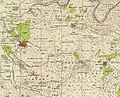 Dayr al-Hawa, Mandate survey, 1:20,000
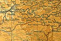 Dayr al-Hawa, 1945, 1:20,000


Remove ads
Archaeology
Coins and ceramics from the Byzantine era have been found here.[21]
See also
References
Bibliography
External links
Wikiwand - on
Seamless Wikipedia browsing. On steroids.
Remove ads