Top Qs
Timeline
Chat
Perspective
Desnianskyi District, Kyiv
Urban district in Kyiv in Ukraine From Wikipedia, the free encyclopedia

Remove ads
The Desnianskyi District[a] is an administrative raion (district or borough) of the city of Kyiv, the capital of Ukraine. It is located in the north-eastern part of the city on the Left Bank[b] of the Dnieper River and is the most populous district of Kyiv. It is also the second largest district, with the total area of ca. 14.2 ha.


.svg)
The Desnianskyi District mainly consists of two microdistricts – Troieshchyna and Lisovyi – making it predominantly residential in nature. There is only one clear-cut, (yet small) industrial zone called Kulykove on the border with Dniprovskyi Raion. This fact explains why the district has the lowest number of registered business entities among Kyiv raions.[2] Much like commuter town, therefore, Desnianskyi District has very little commercial or industrial activity beyond a small amount of retail, oriented toward serving the locals. However, it differs from commuter towns in that it forms part of the city proper and is not regarded as suburb in a classical sense. Still, its currently weak transportation links with the major part of the city on the Right Bank make it appear as a "city inside a city", which is especially true for Troieshchyna microdistrict.[3]
Remove ads
History
The first written reference of the lands that today form part of Desnianskyi District dates back to 1667.[4] Until 1927 the area of the raion belonged to the Oster uyezd of the Chernigov Governorate. Since then it became part of the city of Kyiv. In 1932 the area was reorganized under the Petriv (Podil) Raion. It was not until 1987 when the area was reorganized into a separate raion partially out of the neighboring Dnipro Raion and was named as the Vatutin Raion.
Troieshchyna
Residential development of what would become known as Troieshchyna microdistrict started in 1966. However it was not until the completion of Pivnichnyi Bridge (named Moskovskyi Bridge until 2018[5]) in 1976 that the development became genuinely large-scale.[6]
Remove ads
Population
Language
Distribution of the population by native language according to the 2001 census:[7]
Gallery
 Troieshchyna microdistrict
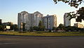 Konotop Battle Square – the centre of Lisovyi microdistrict
 Pivnichnyi Bridge – the key transportation link connecting Desnianskyi District with the rest of the city on west bank of the Dnieper
 Cathedral of the Holy Trinity in Troieshchyna microdistrict
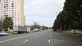 Lisovyi avenue in Kyiv
 Pier near the park Muromets


.jpg)

.jpg)

Notes
Remove ads
References
External links
Wikiwand - on
Seamless Wikipedia browsing. On steroids.
Remove ads