Top Qs
Timeline
Chat
Perspective
Districts of Suriname
Administrative divisions in Suriname From Wikipedia, the free encyclopedia

Remove ads
Overview


Regions of Suriname by number and name
Remove ads
History
Summarize
Perspective
The country was first divided up into subdivisions by the Dutch on October 8, 1834, when a Royal Decree declared that there were to be 8 divisions and 2 districts:[2]
- Upper Suriname and Torarica
- Para
- Upper Commewijne
- Upper Cottica and Perica
- Lower Commewijne
- Lower Cottica
- Matapica
- Saramacca
- Coronie (district)
- Nickerie (district)
The divisions were areas near the capital city, Paramaribo, and the districts were areas further away from the city.
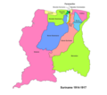 Suriname districts 1914-1917
 Suriname districts 1958-1967
 Suriname districts 1968-1985


In 1927, Suriname's districts were revised, and the country was divided into 7 districts. In 1943, 1948, 1949, 1952 and 1959 further small modifications were made. In 1968 the districts were redrawn again, into[3]
- Nickerie
- Coronie
- Saramacca
- Brokopondo
- Para
- Suriname
- Paramaribo
- Commewijne
- Marowijne
These divisions remained until 1980, when yet again, the borders of the districts were redrawn, however, with the following requirements:
- Changes in the old boundaries were made only if it leads to improved functioning
- Each area should be developed
- The new boundaries should respect the identities of indigenous people.
The last changes to the districts were in 1985.[3]
Remove ads
See also
References
External links
Wikiwand - on
Seamless Wikipedia browsing. On steroids.
Remove ads