Top Qs
Timeline
Chat
Perspective
Division No. 9, Newfoundland and Labrador
Census division in Newfoundland and Labrador, Canada From Wikipedia, the free encyclopedia
Remove ads
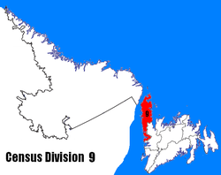
Census Division No. 9 is composed of the area of the province of Newfoundland and Labrador called the Northern Peninsula. It has a land area of 13,527.12 km² (5,222.85 sq mi) and had a population of 15,607 at the 2016 census.[1] The largest community is the town of St. Anthony, near its northern tip, on the Atlantic Ocean coast.
It includes most of the Great Northern Peninsula, along with Gros Morne National Park.
Remove ads
Demographics
In the 2021 Census of Population conducted by Statistics Canada, Division No. 9 had a population of 14,733 living in 6,640 of its 9,366 total private dwellings, a change of -5.6% from its 2016 population of 15,607. With a land area of 13,209.48 km2 (5,100.21 sq mi), it had a population density of 1.1/km2 (2.9/sq mi) in 2021.[4]
Towns
Summarize
Perspective
Remove ads
Unorganized subdivisions
- Subdivision A (Includes: Wiltondale, Lomond, Green Point)
- Subdivision C (Includes: Plum Point, St. Barbe, Savage Cove)
- Subdivision D (Includes: Ship Cove, Straitsview, Great Brehat)
- Subdivision F (Includes: Croque, Williamsport, Grandois)
- Subdivision G (Includes: Eddies Cove West, Barr'd Harbour)
- Subdivision H (Includes: Three Mile Rock, Portland Creek, Shallow Bay)
References
Sources
Wikiwand - on
Seamless Wikipedia browsing. On steroids.
Remove ads

