Top Qs
Timeline
Chat
Perspective
Durgavati River
River in Bihar, India From Wikipedia, the free encyclopedia
Remove ads
The Durgavati River, ( 𑂠𑂳𑂩𑂹𑂏𑂰𑂫𑂞𑂲 𑂢𑂠𑂹𑂠𑂲 ) (also called Durgaoti or Durgauti and spelt as Durgawati) which flows through Kaimur district in the Indian state of Bihar, is a tributary of the Karmanasa.
Remove ads
Course
The source of the Durgavati is about 11 kilometres (7 mi) east of that of the Karmanasa. In its upper reaches it is a rocky channel 6 to 9 metres (20 to 30 ft) wide. It runs nearly north for about 14 kilometres (9 mi) when it plunges down the rocky boundary of the table land in to the head of deep glen named Kadhar Kho. There it is joined by three other torrents that like itself rise on the table land of the Turkan Kharawars and fall down the rocks at the head of the same glen. These three torrents are the Lohara, Hatiyadub and Kothas.[1] The Durgavati joins the Karmanasa as a right bank tributary.[2]
Remove ads
Waterfalls
The Durgavati Falls, 80 metres (260 ft) high, on the Durgavati River is at the edge of the Rohtas Plateau. [3]
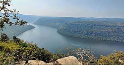
Durgavati Reservoir
The Durgavati Reservoir, also known as Karamchat Dam is a water storage Dam located near Karamchat village in Kaimur district. The foundation stone for the project was laid in 1976 by Jagjivan Ram, who was a Union minister at the time. It can be reached via Sasaram to Kudra-Chenari-Malahipur road. [4]
See also
- Dharmawati River
- Durgavati Canal
- Chausa Canal
References
Wikiwand - on
Seamless Wikipedia browsing. On steroids.
Remove ads


