Top Qs
Timeline
Chat
Perspective
Galguduud
Region of Somalia From Wikipedia, the free encyclopedia
Remove ads
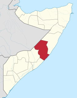
Galguduud (Somali: Galgaduud, Arabic: جلجدود, Italian: Galgudud or Ghelgudud) is an administrative region (gobol) of Galmudug state in central Somalia.[4] Its administrative capital is Dusmareb. The largest town in the region is El Buur, which lies at the centre of the region.
Galguduud is bordered by Ethiopia; the Somali regions of [[Mudug], Hiran, and [Middle Shebelle]] (Shabeellaha Dhexe); and the Indian Ocean. The largest clan in this region is the Hawiye, specially the Murusade subclan, as well as the Habargidir, The region of Galgaduud and southern Mudug formed the Galmudug State by 2016, which considers itself an autonomous state within the larger Federal Republic of Somalia, as defined by the Provisional Constitution of the Federal Republic of Somalia.[5]
Remove ads
Districts
Galguduud Region consists of 8 districts:[6][7]
- Dusmareb (Dhusamareb) District
- El Bur (Ceelbuur) District
- [[abudwak District|
- El Garas (Ceel Garas) District
- Adado (Cadaado) District.
- Xiindheere]] District.
- Galhareri District.
- Bargan (Bargaan) District.
- El Dher (Ceeldheer) District.
- Wabho District
Borders
Galguduud is bordered by Somali galbeed or the Feerfeer-Dharkayn Geenyo Line to the west, the Somali region of Mudug to the north; Hiran and Middle Shebelle (Shabeellaha Dhexe) to the south, and the Indian Ocean to the east.
References
External links
Wikiwand - on
Seamless Wikipedia browsing. On steroids.
Remove ads


