Top Qs
Timeline
Chat
Perspective
Geography of Arunachal Pradesh
From Wikipedia, the free encyclopedia

Remove ads
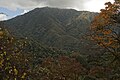
Arunachal Pradesh is primarily a hilly tract nestled in the foothills of the Himalayas in northeast India. It is spread over an area of 83,743 km2 (32,333 sq mi).[3] 98% of the geographical area is land out of which 80% is forest cover;[1] 2% is water.[4] River systems in the region, including those from the higher Himalayas and Patkoi and Arakan Ranges, eventually drain into the Brahmaputra River.[5]

Elevation ranges from mountains that are above 7,000 metres (23,000 ft),[6] to the towns in the plains with an elevation of less than 300 metres (980 ft).[7] Arunachal shares international borders with Bhutan, Tibet (China) and Burma (Myanmar). Internally, Arunachal borders the states of Assam and Nagaland. Arunachal is called the "orchid state of India"[8][9] and "dawn-lit mountain/Land of Dawn/Land of Dawn-Lit Mountains".[10][11]
Remove ads
Area and borders
Arunachal Pradesh is located in northeast India, bordering Bhutan, Tibet (China) and Myanmar internationally.[12] The border with Bhutan is 160 km (99 mi), the China border is 1,080 km (670 mi), and the Myanmar border is 440 km (270 mi).[12] Internal borders includes the Assam-Arunachal Pradesh border 804.1 km (499.6 mi),[13] while the border with Nagaland is 55 km (34 mi).
The territory covers 83,743 km2 (32,333 sq mi).[3] 98% of the geographical area is land.[1] Most of this land state is hilly terrain, with flat land covering about 4,450 km2 (1,720 sq mi).[12] Water covers 2% of the area.[4] It is the 14th largest among the states and union territories of India by area.[14]
Remove ads
Physical geography
Summarize
Perspective
Topography and relief
Relief range varies between plains that are a few hundred meters in height and mountains above 7,000 metres (23,000 ft).[15] The elevation of the towns of Naharlagun, Pasighat and Tezu in the south are 290 m, 155 m and 210 m respectively,[7] while Kangto, Nyegi Kangsang and the Gorichen group of mountains are some of the highest peaks in this region of the Himalayas.[16] The southern borders of Arunachal Pradesh are encompassed by the Shivalik ranges which merge into plains.[15] The hills and mountains have associated features such as valleys and intermontane plateaus, that is plateaus between mountains.[15]

60km
37miles
37miles
1
47
46
45
44
43
42
41
40
39
38
37
36
35
34
580m
275m
33
32
31
30
29
28
27
26
25
24
23
22
21
20
19
18
17
16
15
14
13
12
11
10
9
8
7
6
5
4
3
2
Passes and mountains in Arunachal, or on or close to its borders.[17][18][19][20]
 47: Tsangdhar
Legend:
![]() 1: Gori Chen
1: Gori Chen
![]() 2: Kangto
2: Kangto
![]() 3: Bum La Pass
3: Bum La Pass
![]() 4: Yonggyap La
4: Yonggyap La
![]() 5: Nyegyi Kansang
5: Nyegyi Kansang
![]() 6: Diphu Pass
6: Diphu Pass
![]() 7: Sela Pass
7: Sela Pass
![]() 8: Dzo La
8: Dzo La
![]() 9: Chubumbu La
9: Chubumbu La
![]() 10: Gyoa La
10: Gyoa La
![]() 11: Lo La
11: Lo La
![]() 12: Shagam La
12: Shagam La
![]() 13: Tama La
13: Tama La
![]() 14: Tapgyu La
14: Tapgyu La
![]() 15: Chupung La
15: Chupung La
![]() 16: Kashong La
16: Kashong La
![]() 17: Andra La
17: Andra La
![]() 18: Zhabu La
18: Zhabu La
![]() 19: Kaya La
19: Kaya La
![]() 20: Pangsau Pass
20: Pangsau Pass
![]() 21: Kumjawng Pass
21: Kumjawng Pass
![]() 22: Chaukan Pass
22: Chaukan Pass
![]() 23: Hpungan Pass
23: Hpungan Pass
![]() 24: Dafla Range High Point
24: Dafla Range High Point
![]() 25: Dapha Bum
25: Dapha Bum
![]() 26: Pakhain Range High Point
26: Pakhain Range High Point
![]() 27: Tulung La
27: Tulung La
![]() 28: Chumo
28: Chumo
![]() 29: Lusha Pass
29: Lusha Pass
![]() 30: Kangri Karpo La
30: Kangri Karpo La
![]() 31: Adjamkho La
31: Adjamkho La
![]() 32: Tsang Khang La
32: Tsang Khang La
![]() 33: Glei Dakhru
33: Glei Dakhru
![]() 34: Mayodia Pass
34: Mayodia Pass
![]() 35: Kepang La
35: Kepang La
![]() 36: Siang Pass
36: Siang Pass
![]() 37: Aguia La
37: Aguia La
![]() 38: Hadigra Dakhru
38: Hadigra Dakhru
![]() 39: Milakatong La
39: Milakatong La
![]() 40: Chera La
40: Chera La
![]() 41: Tse La
41: Tse La
![]() 42: Poshing La
42: Poshing La
![]() 43: Shoka La
43: Shoka La
![]() 44: Tunga La
44: Tunga La
![]() 45: Vorjing Peak
45: Vorjing Peak
![]() 46: Lamdo La
46: Lamdo La
.jpg)

Parts of the Lohit district, Changlang district and Tirap district are covered by the Patkai hills. The hills extend towards Nagaland, and form a natural boundary between India and Burma.[28][29]
Namcha Barwa Himal range extends into India up to Siyom River.[30]
Major hills found in this region include:[31]
- Aka Hills
- Daphla Hills
- Miri Hills
- Abor Hills
- Mishmi Hills
- Patkai Hills
60km
37miles
37miles
Mishmi Hills
Bomdila
2415m
Khonsa
1278m
Changlang
580m
Hayuliang
750m
Tezu
210m
Roing
390m
Anini
1968m
Yingkiong
500m
Pasighat
155m
Aalo
300m
Daporijo
500m
Koloriang
1004m
Naharlagun
290m
Seppa
363m
Ziro
1572m
Tawang
3025m
Naga Hills
Patkai Bum
Dafla Hills
Miri Hills
Arbor Hills
Drainage and river systems
Water/wetland cover is 154,609 hectares (1,546.09 km2) or 1.91% of the total area.[4] Out of this, 86% of wetlands are rivers.[4] Lohit district and Dibang Valley district have the highest number of wetlands in the state.[4]


The major river systems are (from west to east clockwise):[34][35]
All of these are fed by snow from the Himalayas and numerous rivers and rivulets and eventually flow into Siang/Brahmaputra. Abrasion by the rivers which flow through the mountains has created a broad valley, which is a major feature of the geography of the state.

Other rivers include Tawang Chu, Dikrong, Ranga, Kamala/Kamla, Kamplang, Siyum, Dihing/ Noadihing and Tirap.[36]

- Four major river basins of the state
 Kameng River Basin
 Subansiri River basin
 Dibang River basin
 Lohit River basin


Remove ads
Biodiversity
Summarize
Perspective
Eco-regions and forest types
Arunachal consists of a number of eco-regions. At the lowest elevations, at Arunachal Pradesh's border with Assam, are the Brahmaputra Valley semi-evergreen forests. Much of the state, including the Himalayan foothills and the Patkai hills, are home to Eastern Himalayan broadleaf forests. Towards the northern border with Tibet, with increasing elevation, come a mixture of Eastern and Northeastern Himalayan subalpine conifer forests followed by Eastern Himalayan alpine shrub and meadows.[citation needed]
- Ecoregions


Climatically, the forests can be categorised as Tropical forests, subtropical forests, temperate forest, subalpine coniferous forest, alpine and secondary forests.[37][38] At the lowest elevations, densely forested areas are seen with the trees ranging from seasonal tropical forest to broadleaf and semi-alpine coniferous forests. Alpine shrubs and meadows follow, ultimately leading to ice-clad peaks.

The Forest Research Institute of India's India State of Forest Report 2019 lists area under different forest types in the state.[39] The major forest types as a percentage of the forest cover area are:
- East Himalayan Sub-Tropical Wet Hill Forest = 24.35%[39]
- East Himalayan Wet Temperate Forest = 22.92%[39]
- East Himalayan Sub-Alpine Birch/Fir Forest = 13.46%[39]
- Alpine Pastures = 6.73%[39]
- Sub-Himalayan Light Alluvial Semi-Evergreen Forest = 6.60%[39]
- Others = Remaining[39]
Forest cover varies from 54% in Tawang district to 92% in Papum Pare district.[40] There are 110 species of trees.[39]
Protected areas include the Dihang-Dibang Biosphere Reserve, Namdapha National Park, Mouling National Park, and 11 wildlife sanctuaries and reserves including elephant reserves, tiger reserves and an orchid sanctuary,[a] covering about 12% of the geographical area of the state.[41]
Flora and fauna
Flora and fauna in the state includes over 4000 species of flowering plants,[42] 600 bird species, 200 fish species,[43] 42 amphibian species, 85 terrestrial mammals and a wide number of insects, butterflies and reptiles.[37][44] Orchids, fern, bamboo, cane, rhododendrons, oak, hedychiums, and various medicinal plants form a diverse range of the state's green cover. Among the crops grow are rice, nigros, maize, millet, wheat, pulses, sugarcane, ginger, and oilseeds. Arunachal is also ideal for horticulture and fruit orchards. Its major industries are rice mills, fruit preservation and processing units, and handloom handicrafts Apart from them, the forests of Arunachal are also home to a large number of people belonging to the different tribes. These tribal people, aloof from urbanization, dwell in these forests where the various forest-based products form a part of their livelihood. Right from the south of the state where the altitude is low we get to see a variety of trees like teak, sal, gutjan, more.
 The Strobilanthus flower at the Namdapha National Park
 Hornbills at the Namdapha National Park
 Male azure sapphire
 View of Eaglenest forest canopy


_(40297843010).jpg)

Remove ads
Climatic conditions

As per the Köppen–Geiger climate classification system, the most prevalent climate types in the state are humid subtropical climate and monsoon-influenced humid subtropical climate.[45] Other climates include subtropical highland climate, monsoon-influenced warm-summer humid continental climate and monsoon-influenced subarctic climate.[45]
The regions in the lower belts of the state experience hot and humid climates, with a maximum temperature in the foothills reaching up to 40 °C (during the summer). The average temperature in this region in winter ranges from 15° to 21 °C while that during the monsoon season remains between 22° and 30 °C.[46][47][48]
Arunachal Pradesh experiences heavy rainfall during May to September. The average rainfall recorded in Arunachal Pradesh is 300 centimeters, varying between 80 centimeters and 450 centimeters.[49]
Remove ads
Human geography
Demographics
Administrative divisions

Districts of Arunachal Pradesh since 2018
Legend: Capital
  Year created 2018
  Year created 2017
  Year created 2015
  Created before 2015
Legend:
Remove ads
See also
References
Bibliography
Wikiwand - on
Seamless Wikipedia browsing. On steroids.
Remove ads