Top Qs
Timeline
Chat
Perspective
Geography of Ottawa
From Wikipedia, the free encyclopedia
Remove ads
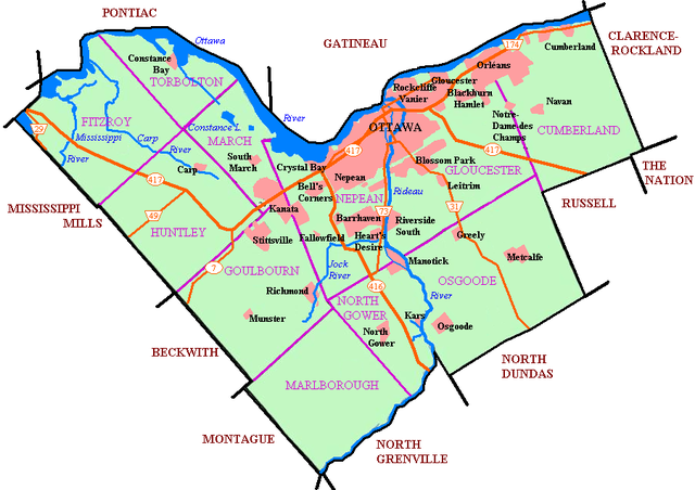
This is the outline of the geography of the city of Ottawa, the capital of Canada. Ottawa's current borders were formed in 2001, when the former city of Ottawa amalgamated with the ten other municipalities within the former Regional Municipality of Ottawa–Carleton. Ottawa is now a single-tiered census division, home to 1,017,449 people.[1]

The city centre is located at the confluence of the Ottawa and Rideau Rivers. The Ottawa River forms the entire northern boundary of the city which it shares with the province of Quebec's municipalities of Pontiac and Gatineau. The northern boundary begins in the west at Arnprior and continues east to Rockland. The boundary then turns south in a straight line, separating the former Township of Cumberland (now in Ottawa) and the City of Clarence-Rockland. It then turns west in another straight line separating the former Township of Cumberland with the municipalities of The Nation and Russell. It then turns south separating Russell from the former Township of Osgoode (now in Ottawa). That boundary runs south in a straight line, then turns west separating Osgoode from the municipality of North Dundas. That boundary runs west in a straight line before turning north separating Osgoode from the municipality of North Grenville. This is another straight line, running north until the Rideau River near Kemptville. The boundary follows the river upstream until almost reaching Merrickville. The boundary then runs in a northwest direction in a straight line with a number of jogs. It separates the municipalities of Montague, Beckwith and Mississippi Mills from the former townships of Marlborough, Goulbourn, Huntley and Fitzroy.
Remove ads
Topography
Summarize
Perspective
The highest point in Ottawa is 166 m (545 ft) above sea level, and is located 2.6 km (1.6 mi) SSE of Manion Corners (45°14′05″N 76°03′03″W).[2] The lowest point in the city is the Ottawa River, at 44 m (144 ft) above sea level.
Highest points by ward

Remove ads
Geology
Summarize
Perspective


Many features of geologic interest are found in Ottawa.[3]
Remove ads
Climate
Classification
Recent data
Notes
- Extreme high and low temperatures in the table below were recorded at Ottawa from March 1872 to October 1889 and at Ottawa CDA from November 1889 to present.
Historical data
Remove ads
Rivers and creeks
Summarize
Perspective


Tributaries of the Ottawa River (from east to west):
- Becketts Creek
- Cardinal Creek
- Taylor Creek
- Bilberry Creek
- Green's Creek
- Mud Creek
- Borthwick Creek
- Nicolet Drain
- Ramsay Creek
- McEwan Creek
- Rideau River
- Rideau Canal (artificial)
- Graham Creek
- Still Water Creek
- Watts Creek
- Shirley's Brook
- Constance Creek
- Carp River
- Mississippi River
- Cartwrights Creek
- Cody Creek
- Madawaska River (mouth not in Ottawa)

Tributaries of the Rideau River (from north to south):
- Sawmill Creek
- Nepean Creek
- Black Rapids Creek
- Mosquito Creek
- Jock River
- Mahoney Creek
- Nichols Creek
- Kings Creek
- Mud Creek
- Stevens Creek
- Cranberry Creek
- McDermot Drain (mouth not in Ottawa)
- Brassills Creek
- Rideau Creek
Other rivers and creeks within City of Ottawa:
- Bear Brook
- South Indian Creek
- Shaws Creek
- McKinnons Creek
- North Castor River
- Black Creek
- Middle Castor River
- South Castor River
Features of the Ottawa River


(from east to west)
- Petrie Island
- Lower Duck Island
- Upper Duck Island
- Governor Bay
- Nepean Point
- Victoria Island
- Chaudière Island
- Chaudière Falls
- Nepean Bay
- Lemieux Island
- Bell Island
- Merrill Island
- Nicholas Island
- Lazy Bay
- Little Chaudière Rapids
- Remic Rapids
- Bate Island
- Cummingham Island
- Riopelle Island
- Deschênes Rapids
- Britannia Bay
- Graham Bay
- Rocky Point
- Crystal Bay
- Beatty Point
- Shirleys Bay
- Haycock Island
- Chartrand Island
- Innis Point
- Aylmer Island
- Pinhey Point
- Stony Point
- Horseshoe Bay
- Constance Bay
- Sand Point
- Buckham's Point
- Buckham's Bay
- Crown Point
- Woolsey Narrows
- Alexandra Island
- Kedey's Island
- Chats Falls
- Morris Island
- Lavergne Point
- Lavergne Bay
- Pickerel Bay
- Snake Island
- Indian Point
- Marshall Bay
- Pocket Bay
- Goodwin Bay
Features of the Rideau River

(from north to south)
- Rideau Falls
- Green Island
- Maple Island
- Porter Island
- Cummings Island
- Hog's Back Falls (Prince of Wales Falls)
- Mooney's Bay
- Black Rapids
- Nicholls Island
- Long Island
- Mahogany Harbour
- Collins Point
- Sanders Island
- James Island
- McGahey's Bend
Waterfalls
Remove ads
Lakes

- Brewer Park Pond
- Constance Lake
- Lac des Chats
- Dow's Lake
- Lac Deschênes
- Lake Madawaska
- McKay Lake
- Mud Lake
- Mud Pond
- Sand Pits Lake
Notes
- Extreme high and low temperatures in the table below were recorded at Ottawa from March 1872 to October 1889 and at Ottawa CDA from November 1889 to present.
References
External links
Wikiwand - on
Seamless Wikipedia browsing. On steroids.
Remove ads
