Top Qs
Timeline
Chat
Perspective
Grafarvogur
District in Reykjavík, Iceland From Wikipedia, the free encyclopedia
Remove ads
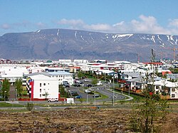
Grafarvogur (Icelandic pronunciation: [ˈkraːvarˌvɔːɣʏr̥]) is among the largest residential districts of Reykjavík, Iceland. It is a relatively new neighbourhood and is located on the eastern-most side of Reykjavík. Major construction began in the late 1980s and continued well into the 1990s.[1][2]
Remove ads
Neighbourhoods
The district includes 15 neighbourhoods: Hamrar [ˈhamrar̥], Foldir [ˈfɔltɪr̥], Hús [ˈhuːs], Rimar [ˈrɪːmar̥], Borgir [ˈpɔrcɪr̥], Víkur [ˈviːkʏr̥], Engi [ˈeiɲcɪ], Spöng [ˈspœyŋk], Staðir [ˈstaːðɪr̥], Höfðar [ˈhœvðar̥], Bryggjuhverfi [ˈprɪccʏˌkʰvɛrvɪ], Geirsnef [ˈceir̥sˌnɛːf], Gufunes [ˈkʏːvʏˌnɛːs], keldur, and Geldinganes [ˈcɛltiŋkaˌnɛːs]. Of those, five (Rimar, Hamrar, Borgir, Víkur and Foldir) fall within the boundaries of the historic Gufunes estate.[3]
Remove ads
Shopping
Grafarvogur currently has one medium-sized shopping centre called Spöngin. It's not a mall in itself but a cluster of shops, Hagkaup being the largest. Also, there are small clusters of shops in Hverafold, in Víkurvegur and Langirimi Streets. These shopping centres are much smaller and contain only a few shops, the supermarkets being the largest.
References
External links
Wikiwand - on
Seamless Wikipedia browsing. On steroids.
Remove ads


