Top Qs
Timeline
Chat
Perspective
Greater Buenos Aires
Urban agglomeration in Argentina From Wikipedia, the free encyclopedia

Remove ads
Greater Buenos Aires (Spanish: Gran Buenos Aires, GBA), also known as the Buenos Aires Metropolitan Area (Spanish: Área Metropolitana de Buenos Aires, AMBA),[3] refers to the urban agglomeration comprising the Autonomous City of Buenos Aires and the adjacent 24 partidos (districts) in the Province of Buenos Aires. Thus, it does not constitute a single administrative unit. The conurbation spreads south, west and north of Buenos Aires city. To the east, the River Plate serves as a natural boundary.
.jpg)


The term is also related to other expressions that are not necessarily well defined: the "Buenos Aires conurbation" (Conurbano Bonaerense); the "Greater Buenos Aires Agglomeration" (Aglomerado Gran Buenos Aires); and the "Metropolitan Area of Buenos Aires" (Área Metropolitana Buenos Aires, AMBA).
Colloquially, Argentines refer to the Conurbano Bonaerense as the set of 30 counties that surround the City of Buenos Aires and which are mostly populated by working-class or middle-class communities.
Remove ads
History
Summarize
Perspective
The term Gran Buenos Aires ("Greater Buenos Aires") was first officially used in 1948, when Domingo Mercante, the Governor of Buenos Aires Province, signed a bill delineating as such an area covering 14 municipalities surrounding the City of Buenos Aires.[4]
Urban sprawl, especially between 1945 and 1980, created a vast metropolitan area of over 3,800 km² (1,500 mi²)[5] – or 19 times the area of Buenos Aires proper. The 24 suburban partidos (counties) grew more than sixfold in population between the 1947 and 2022 censuses – or nearly 2.5% annually, compared to 1.4% for the nation as a whole.[1][6]
While annual growth for the suburban area slowed to 0.8% between 2010 and 2022, the 12 million inhabitants in the entire 30-county area - plus the City of Buenos Aires (3 million) - account for a third of the total population of Argentina and generate nearly half (48%) of the country's GDP.[5]
As urbanization progressed and the metro area grew in both area and density, six additional partially urbanized partidos (totaling 1,062,991 population as of the 2022 census)[1] were added to the metropolitan area in 2006 by Law 13473 - which also adds neighboring Greater La Plata's 938,287 to the total.[7]

Remove ads
Definition
Summarize
Perspective


The National Institute of Statistics and Censuses (INDEC) has defined Greater Buenos Aires.[8]
There are three main groups within the Buenos Aires conurbation. The first two groups (24 partidos) comprise the traditional conurbation - or the "conurbation proper" - while the third group of six partidos is in the process of becoming fully integrated with the rest.
- Fourteen fully urbanized partidos
- Ten partidos partially urbanized
- Six partidos not yet conurbated
The six additional partially urbanized partidos added to the metropolitan area in 2006 by Law 13473 (which also adds Greater La Plata's 938,287 to the total) are:[7]
- Escobar (256,449)
- General Rodríguez (143,211)
- Marcos Paz (67,154)
- Pilar (395,072)
- Presidente Perón (102,128)
- San Vicente (98,977)
The 2022 Census later included, for statistical purposes, these six outlying partidos (totaling 497,700):[9]
Remove ads
List of partidos
List of cities
Summarize
Perspective

Remove ads
Gallery
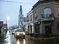 Berazategui
 Ciudad Evita (La Matanza Partido)
 Florencio Varela
 General San Martín
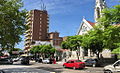 Monte Grande (Esteban Echeverría Partido)
 Olivos (Vicente López Partido)
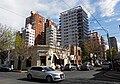 Quilmes
 Tigre
Tigre Pan-American Expressway, north of Buenos Aires


References
Further reading
Wikiwand - on
Seamless Wikipedia browsing. On steroids.
Remove ads