Top Qs
Timeline
Chat
Perspective
Hatteras, North Carolina
Census-designated place in North Carolina, United States of America From Wikipedia, the free encyclopedia

Remove ads
Hatteras is an unincorporated village and census-designated place (CDP) in Dare County, North Carolina, United States, on the Outer Banks island of Hatteras, at its extreme southwestern tip. As of the 2010 census it had a population of 504.[2] Immediately to the west of the village of Hatteras is Hatteras Inlet which separates Hatteras Island from the neighboring Ocracoke Island. North Carolina Highway 12 passes through the community linking it to Frisco to the east and Ocracoke to the west (via a ferry across Hatteras Inlet).
The residents of Hatteras are governed by the Dare County Board of Commissioners. Hatteras is part of District 4, along with Avon, Buxton, Frisco, Rodanthe, Waves and Salvo.
Remove ads
Demographics
2020 census
As of the 2020 United States census, there were 577 people, 207 households, and 130 families residing in the CDP.
Remove ads
Attractions and recreation
Pamlico Sound, which separates Hatteras and Ocracoke Islands, is one of the largest estuarine systems in the world and offers a variety of fishing opportunities.[5]
Climate
Hatteras has a humid subtropical climate (Cfa). Hatteras experiences hot summers, somewhat moderated by the Atlantic Ocean, and some of the mildest winters in the state, with no month having an average low temperature below 40 °F (4.4 °C). Because of its location many miles off the coast of Mainland USA in the direct path of the gulf stream, Hatteras experiences year round low temperatures similar to the northern gulf of Florida or southern coastal Georgia, despite being much farther north.[6]
History
Hatteras was named after the Hatteras Indians.[8]
Hatteras Village was cut off from the rest of the island on September 18, 2003,[9] when Hurricane Isabel washed a 3,000-foot-wide (910 m) and 30-foot-deep (9.1 m) channel called Isabel Inlet at the north end of Hatteras village. The tear was subsequently repaired and restored by sand dredged by the Army Corps of Engineers.[10]
The Ellsworth and Lovie Ballance House and Hatteras Weather Bureau Station are listed on the National Register of Historic Places.[11]
Remove ads
Transportation
Hatteras is served by Billy Mitchell Airport.
The Village is also home to the Hatteras-Ocracoke Ferry terminal which is the only way for people to access Ocracoke Island from Hatteras Village other than air travel.
Education
Residents are zoned to Dare County Schools. Zoned schools are Cape Hatteras Elementary School and Cape Hatteras Secondary School.[12] The schools are located on NC 12 in Buxton.[13]
Dare County Library has a branch in Hatteras.[14]
Gallery
 View of Pamlico Sound, near Hatteras Inlet from a home in Hatteras on a windy day in June 2007
 View of homes along oceanfront in Hatteras in June 2007
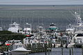
 Busy Hatteras Ferry Lines on a Wednesday in June 2007
 Ferries making trip from Ocracoke to Hatteras, June 2007
 Water tower
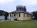 Historical US Weather Bureau office


Notes
References
External links
Wikiwand - on
Seamless Wikipedia browsing. On steroids.
Remove ads