Top Qs
Timeline
Chat
Perspective
Havelland (district)
District in Brandenburg, Germany From Wikipedia, the free encyclopedia
Remove ads
Havelland (German pronunciation: [ˈhaːfəlˌlant]) is a district or county in Brandenburg, Germany. It is bounded by (from the north and clockwise) the districts of Ostprignitz-Ruppin and Oberhavel, the city-state of Berlin, the district of Potsdam-Mittelmark, the city of Brandenburg and the state of Saxony-Anhalt (districts of Jerichower Land and Stendal).
This article needs additional citations for verification. (August 2022) |


brown = more than 45 m above sea level,
green = forests, mostly more than 45 m above sea level
Remove ads
History
The district was established in 1993 by merging the former districts of Nauen and Rathenow.
Demography
 Development of Population since 1875 within the Current Boundaries (Blue Line: Population; Dotted Line: Comparison to Population Development of Brandenburg state)
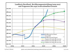 Recent Population Development and Projections (Population Development before Census 2011 (blue line); Recent Population Development according to the Census in Germany in 2011 (blue bordered line); Official projections for 2005-2030 (yellow line); for 2014-2030 (red line); for 2017-2030 (scarlet line)


Remove ads
Geography
Geographically the Havelland refers to the land either side of the Havel river and the area surrounded by the large "U" bend in its course between the city of Berlin and its confluence with the Elbe river. The district mainly consists of the areas north of the Havel river.
Coat of arms

The red eagle is the heraldic animal of Brandenburg. The head of the eagle is part of the coat of arms of Rathenow. The swan is often used as a symbol for the Havelland region.
Towns and municipalities
Remove ads
References
External links
Wikiwand - on
Seamless Wikipedia browsing. On steroids.
Remove ads