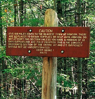
The Hundred-Mile Wilderness is the section of the Appalachian Trail in the state of Maine running between Monson and Abol Bridge over the West Branch of the Penobscot River just south of Baxter State Park. It is generally considered the most remote section of the Appalachian Trail,[1][2] and one of the most challenging to navigate and traverse. This section of the trail is crossed by several logging roads and is maintained by the Maine Appalachian Trail Club. It consists of a small corridor of protected wilderness surrounded by large tracts of public and private land controlled by paper companies. An increasing amount of the adjoining lands are being protected by groups like the Appalachian Mountain Club and the Nature Conservancy.
Quick Facts Trailheads, Highest point ...
| Hundred Mile Wilderness |
|---|
 Warning sign near Abol Bridge, the northern terminus of the Hundred Mile Wilderness. |
| Trailheads | Route 15 north of Monson, Abol Bridge on the Golden Road |
|---|
| Highest point | 3,654 ft (1,114 m), White Cap Mountain |
|---|
| Lowest point | 493 ft (150 m), Lower Jo-Mary Lake |
|---|
| Sights | Alpine tundra, Barren Mountain Ledges, Glacial erratics, Gulf Hagas, Nahmakanta Lake, Old-growth forests, Rocky outcrops, Rivers, Little Wilson Falls, Wetland, Wildlife, Valleys |
|---|
| Hazards | Severe weather
Mosquitos
Yellowjackets
Biting flies
Steep grades
Dangerous fordings
Diarrhea from water
Poison ivy
|
|---|
|
 Map |
Close
|
|---|
|
|
|
|
|
Appalachian Trail South |
|
|
|
|
 SR 15 SR 15 |
|
|
|
|
Leeman Brook Lean-to |
|
|
|
|
Little Wilson Upper Falls |
|
|
|
|
Little Wilson Stream |
|
|
|
|
Big Wilson Stream |
|
|
|
|
Moosehead Subdivision |
|
|
|
|
Wilson Valley Lean-to |
|
|
|
|
Long Pond Stream |
|
|
|
|
Long Pond Stream Lean-to |
|
|
|
|
|
|
|
|
|
Barren Ledges |
|
|
|
|
Barren Mountain |
|
|
|
|
Cloud Pond Lean-to |
|
|
|
|
Fourth Mountain |
|
|
|
|
Third Mountain |
|
|
|
|
Chairback Gap Lean-to |
|
|
|
|
Chairback Mountain |
|
|
|
|
|
|
|
|
|
Katahdin Iron Works Road (KI Rd) |
|
|
|
|
|
|
|
|
|
West Branch Pleasant River |
|
|
|
|
The Hermitage |
|
|
|
|
|
|
|
|
|
Gulf Hagas |
|
|
|
|
|
|
|
|
|
Carl A. Newhall Lean-to |
|
|
|
|
Gulf Hagas Mountain |
|
|
|
|
Sidney Tappan Campsite |
|
|
|
|
Hay Mountain |
|
|
|
|
White Cap Mountain |
|
|
|
|
Katahdin viewpoint |
|
|
|
|
|
|
|
|
|
Logan Brook Lean-to |
|
|
|
|
East Branch Lean-to |
|
|
|
|
East Branch Pleasant River |
|
|
|
|
Little Boardman Mountain |
|
To Jo-Mary Road |
|
|
Johnston Pond Road |
|
|
|
|
Crawford Pond |
|
|
|
|
Cooper Brook |
|
|
|
|
Cooper Brook Falls Lean-to |
|
|
|
|
Jo-Mary Road |
|
|
|
|
Antlers Campsite |
|
|
|
|
Potaywadjo Spring Lean-to |
|
|
|
|
Nahmakanta Stream |
|
|
|
|
Nahmakanta Stream Lean-to |
|
|
|
|
|
|
|
|
|
Nahmakanta Lake |
|
|
|
|
Wadleigh Stream Lean-to |
|
|
|
|
Wadleigh Pond Road |
|
|
|
|
Rainbow Stream Lean-to |
|
|
|
|
Rainbow Lake |
|
|
|
|
Rainbow Ledges |
|
|
|
|
Hurd Brook Lean-to |
|
|
|
|
Golden Road |
|
|
|
|
Abol Bridge |
|
|
|
|
|
|
|
|
|
Appalachian Trail North |
|
|
|
|
|
|
|
|
In 2000, a series of new logging roads and a marked side-trail offered hikers re-supply and lodging opportunities between miles 55 and 65 heading northbound from Monson.
45°36.9′N 69°9.8′W


