Top Qs
Timeline
Chat
Perspective
Huveaune
River in France From Wikipedia, the free encyclopedia
Remove ads
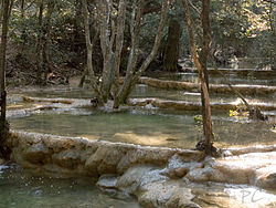
The Huveaune (French pronunciation: [yvon]; Occitan: Evèuna) is a small river in the Provence-Alpes-Côte d'Azur region of southeastern France. It is 48.5 kilometres (30.1 mi) long and flows through the communes of La Penne-sur-Huveaune, Nans-les-Pins, Saint-Zacharie, Plan-d'Aups-Sainte-Baume, Auriol, Roquevaire, Aubagne, and the metropolitan area of Marseille.[1]
The Huveaune rises in the Castelette cave at 590 metres (1,940 ft) in the Sainte-Baume mountain range, and runs into the Mediterranean Sea at Marseille. Its drainage basin is 502 km2 (194 sq mi).[2]


Remove ads
References
Wikiwand - on
Seamless Wikipedia browsing. On steroids.
Remove ads


