Top Qs
Timeline
Chat
Perspective
Inuvik Region
Administrative region in the Northwest Territories, Canada From Wikipedia, the free encyclopedia

Remove ads
The Inuvik Region or Beaufort Delta Region is one of five administrative regions in the Northwest Territories of Canada. According to Municipal and Community Affairs the region consists of eight communities with the regional office situated in Inuvik.[1] Most of the communities are in the Beaufort Sea area and are a mixture of Inuit (mostly Inuvialuit) and First Nations (mostly Gwichʼin).


Inuvik Region communities in the Northwest Territories
Formerly, there was also a Statistics Canada designated census division named Inuvik Region, Northwest Territories, which was abolished in the 2011 Canadian census. The territorial extent of this census division was somewhat larger than the administrative region of the same name.
Remove ads
Administrative Region communities
Summarize
Perspective
The Inuvik Region administrative entity includes the following communities:
Remove ads
Communities in the Inuvik Region
Communities in the Inuvik Region
 Aklavik (2008)
 St. Matthew's Anglican Church, Fort McPherson (2013)
 Inuvik (2021)
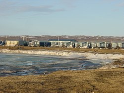 Paulatuk (2005)
 Sachs Harbour (2006)
 Tsiigehtchic (2006)
 Tuktoyaktuk (2013)
 Ulukhaktok (2021)


Climate
Remove ads
Notes
- Climate data was recorded at Fort McPherson from October 1892 to June 1977 and at Fort McPherson Airport from August 1981 to present. Composite data from Fort McPherson A; Climate ID: 2201606; coordinates 67°24′25″N 135°31′35″W; elevation: 35.4 m (116 ft)
- Includes composite data from Inuvik A: Climate ID: 2202571; coordinates 68°18′14″N 133°28′59″W; elevation: 67.7 m (222 ft) and Inuvik Climate / Inuvik UA; WMO ID: 71364 / 71957; 68°19′N 133°31′W; elevation: 103.0 m (337.9 ft) / 103.2 m (339 ft). Sunshine from 1951–1980
- Composite data from Sachs Harbour A; Climate ID: 2503649; coordinates 72°59′37″N 125°14′29″W; elevation: 86.3 m (283 ft) and Sachs Harbour Climate; Climate ID: 2503648; coordinates 72°59′33″N 125°15′15″W; elevation: 87.5 m (287 ft). Sunshine from 1951–1980
Remove ads
References
External links
Wikiwand - on
Seamless Wikipedia browsing. On steroids.
Remove ads