Top Qs
Timeline
Chat
Perspective
Jamacha, San Diego
Community of San Diego in California From Wikipedia, the free encyclopedia
Remove ads
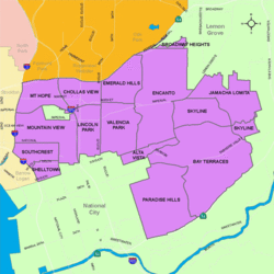
Jamacha (pronounced: HAM-e-shaw) is a neighborhood in the District 4 area of San Diego, California. It is generally bounded by the city of Lemon Grove to the North, Both Lomita and Skyline Communities to the South, Encanto to the West of Imperial Ave. (at Atkins Ave,), and both city of Lemon Grove and Lomita Community to the East. Major thoroughfares include Lisbon Street, Jamacha Road, Woodrow Avenue, and Imperial Ave. The neighborhood is part of the Skyline-Paradise Hills Community Planning Area.[1]
Remove ads
History
Jamacha is named for the Jamacha Valley and Rancho Jamacha, a Mexican land grant estate. The name was variously spelled Xamacha, Jamacha', 'Jamacho, and Gamacha until Jamacha was fixed as the official spelling in the early 20th century. The word is likely derived from a Spanish adaptation of the Kumeyaay Indian word Xamca, meaning "wild gourd. It has been confirmed that Jamacha had a rich history for the Kumeyaay people. In a memo written by Ralph Goff, Chairman of the Campo Band of Mission Indians, to Arleen Garcia-Herbst, Archeologist at Spindrift Archeological Consulting, LLC. "[2]
Remove ads
Background
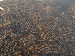
Jamacha is a largely residential neighborhood, with mostly single-family houses, mixed with some multi-family development, Townhomes, and two apartment complexes. There is also some small-scale commercial development in the neighborhood on Imperial Ave, Lisbon St., 69th St., and the corner of Cardiff St. and Jamacha Rd.[3]
Geography
The Skyline-Paradise Hills Community as a whole make up approximately 4,500 acres. The Jamacha consists predominantly of low-density single-family homes spread across the hilly area. The major geographic features are the Jamacha Valley that runs on an east-west axis in the community and give rise to Chollas Creek that flows into San Diego Bay. The San Diego Natural History Museum published geologic mapping indicates that Jamacha is underlain by both the Pliocene-age San Diego Formation and the Eocene-age Mission Valley Formation. Both of these formations are known to be rich in fossils and have produced important paleontological resources, and it has been determined that there are 12 recorded fossil collections within a one-mile radius of Jamacha.
Demographics
Demographic statistics are not available for Jamacha, only data reported in conjunction with the separate neighborhood of Lomita. Jamacha is an ethnically and socially diverse family-friendly neighborhood. The demographics for Jamacha are as follows: Hispanic-Latino is the largest group, followed by African-Americans, Asians, non-Hispanic Whites, Mixed race, and others. The Census data is inaccurate as it was combined with Lomita which is legally a separate neighborhood unrelated to Jamacha. The City of San Diego Police Department created a 2011 Neighborhood Beat Map which merged two legally separate neighborhoods of
Lomita and Jamacha and created a fake communities of Jamacha-Lomita, Jamacha Lomita. Which has caused confusion creating the false name of Jamacha-Lomita in maps and overlays that conflicts with the legally binding Skyline-Paradise Hills Plan.
Remove ads
References
Wikiwand - on
Seamless Wikipedia browsing. On steroids.
Remove ads


