Top Qs
Timeline
Chat
Perspective
Jammu district
District of Jammu and Kashmir administered by India From Wikipedia, the free encyclopedia
Remove ads
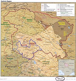
Jammu district is an administrative district of the Jammu division of Indian-administered Jammu and Kashmir in the disputed Kashmir region.[1] It is the most populous district in the Jammu division.[4]
Remove ads
Administrative divisions
Jammu District has 7 Sub-Divisions:
- Jammu South
- Jammu North
- Pura
- Marh
- Akhnoor
- Chowki Choura
- Khour
There are 21 tehsils:[5]
- Akhnoor
- Arnia
- Bahu
- Bhalwal
- Bishnah
- Chowki Choura
- Dansal
- Jammu
- Jammu North
- Jammu South
- Jammu West
- Jourian
- Kharah Balli
- Khour
- Maira Mandrian
- Mandal
- Marh
- Nagrota
- Pargwal
- Ranbir Singh Pura
- Suchetgarh
There are 20 Blocks:
- Akhnoor
- Arnia
- Bhalwal
- Bhalwal Brahmana
- Bishnah
- Chowki Choura
- Dansal
- Khour
- Kharah Balli
- Maira Mandrian
- Mandal
- Marh
- Mathwar
- Miran Sahib
- Nagrota
- Pargwal
- Pura
- Samwan
- Satwari
- Suchetgarh
Remove ads
Demographics
Summarize
Perspective
According to the 2011 census Jammu district has a population of 1,526,406, roughly equal to the nation of Gabon[7] or the US state of Hawaii.[8] This gives it a ranking of 326th in India (out of a total of 640). The district has a population density of 596 inhabitants per square kilometre (1,540/sq mi) . Its population growth rate over the decade 2001-2011 was 12.48%. Jammu has a sex ratio of 871 females for every 1000 males, and a literacy rate of 83.98%.[citation needed] The Scheduled Castes and Scheduled Tribes account for 24.7% and 4.5% of the population of the district.[9]
Languages
The most widely spoken language of Jammu is Dogri. Other languages spoken are Punjabi, Urdu, Hindi, Kashmiri, Gojri and English.
Remove ads
References
External links
Wikiwand - on
Seamless Wikipedia browsing. On steroids.
Remove ads


