Top Qs
Timeline
Chat
Perspective
Jamtara district
District of Jharkhand, India From Wikipedia, the free encyclopedia
Remove ads
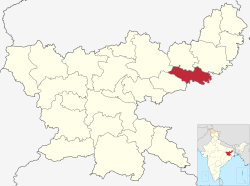
Jamtara district is one of the twenty-four districts of Jharkhand state in eastern India. Jamtara town is the administrative headquarters of this district. The district is situated between 23°10′ and 24°05′ north latitudes and 86°30′ and 87°15′ east longitudes.
This article needs additional citations for verification. (May 2008) |
Remove ads
Administration
Blocks/Mandals
Jamtara district consists of 06 Blocks. The following are the list of the Blocks in Jamtara district:
Demographics
Summarize
Perspective
According to the 2011 census Jamtara district has a population of 791,042,[3] roughly equal to the nation of Comoros[4] or the US state of South Dakota.[5] This gives it a ranking of 486th in India (out of a total of 640).[3] The district has a population density of 439 inhabitants per square kilometre (1,140/sq mi).[3] Its population growth rate over the decade 2001-2011 was 21%.[3] Jamtara has a sex ratio of 959 females for every 1000 males,[3] and a literacy rate of 64.59%. 9.58% of the population lives in urban areas. Scheduled Castes and Scheduled Tribes make up 9.21% and 30.40% of the population respectively.[3]
At the time of the 2011 Census of India, 30.18% of the population spoke Bengali, 29.10% Santali, 27.93% Khortha, 5.92% Hindi, 3.61% Urdu and 1.25% Magahi as their first language.[6]
Remove ads
Economy
In 2006 the Indian government named Jamtara one of the country's 250 most backward districts (out of a total of 640).[7] It is one of the 21 districts in Jharkhand currently receiving funds from the Backward Regions Grant Fund Programme (BRGF).[7]
Politics
There are three Vidhan Sabha constituencies in the district: Nala, Jamtara and Sarath (shared with Deoghar district). All three constituencies are part of Dumka Lok Sabha constituency.
Remove ads
See also
References
External links
Wikiwand - on
Seamless Wikipedia browsing. On steroids.
Remove ads


