Top Qs
Timeline
Chat
Perspective
Jind State
Princely state of India From Wikipedia, the free encyclopedia

Remove ads
Jind State (also spelled Jhind State) was a princely state located in the Punjab and Haryana regions of north-western India. The state was 3,260 km2 (1,260 sq mi) in area and its annual income was Rs.3,000,000 in the 1940s.[1] This state was founded and ruled by the Jats of Sidhu clan.[2]

Remove ads
Location
The area of the state was 1,259 square miles in total and it ranged from Dadri, Karnal, Safidon, and Sangrur.[1][3]
History
Summarize
Perspective
Origin
_of_the_ruling_family_of_Jind_State,_Punjab,_revised_pedigree-table_(1940).jpg)
The ruling house of Jind belonged to the Phulkian dynasty, sharing with the Nabha rulers a common ancestor named Tiloka. Tiloka was the eldest son of Phul Sidhu of the Phulkian Misl.[3] The Jind rulers descended from Sukhchain Singh, the younger son of Tiloka.[4] The Jind State was founded in 1763 by Gajpat Singh after the fall of Sirhind.[3] Other sources give a date of 1768 for the founding of the state.[1]
Gajpat Singh, son of Sukhchain Singh and great-grandson of Phul, launched a rebellion against the hostile authority based out of Sirhind.[1] The rebellion was a Sikh coalition against the Afghan governors of Jind State.[3] As a reward, Gajpat received a large tract of land, which included Jind and Safidon.[3] Gajpat established his headquarters at Jind, building a large, brick fort at the location.[3]

He established the state in 1763 or 1768 and made Sangrur its capital.[1][3] Gajpat was bestowed with the title of Raja by the Mughal emperor Shah Alam in the year 1772.[1][3] As a mark of sovereignty, the Sikh raja minted coins bearing his name.[1][3] Shortly after being bestowed with the raja title by the Mughals, Jind was attacked by Rahim Dad Khan, the governor of Hansi, who was killed in action.[3] In 1774, a dispute arose between Jind and Nabha states.[3] The precarious intra-Phulkian situation led to Gajpat Singh of Jind sending troops against Hamir Singh of Nabha, with the former taking possession of Imloh, Bhadson, and Sangrur from the latter's control.[3] However, the ruler of Patiala State and influential members of the family led to Imloh and Bhadson being returned to Nabha's rule.[3] Sangrur remained with Jind and was not given back to Nabha.[3] A daughter of Gajpat Singh of Jind married Maha Singh of the Sukerchakia Misl and was the mother of Ranjit Singh.[3]
Gajpat Singh ordered the raising of several fortresses, whom were constructed using lakhauri (thin burnt-clay) bricks in the year 1775.[1] One of the forts was built to the left of the present-day Rani Talab and the second was built to the right of present-day Tanga Chowk.[1] There was a family connection shared between Jind State and the Sukerchakia Misl, due to the fact that Gajpat's daughter, Raj Kaur, was the mother of Maharaja Ranjit Singh whom founded the Sikh Empire.[1]
Gajpat Singh died in 1786.[3]
After the passing of Gajpat, his son Bhag Singh succeeded to the throne of Jind in 1789.[1] Bhag Singh is notable as being the first cis-Sutlej or Phulkian Sikh ruler to develop amicable ties with the British East India Company, which developed into a state of allyship between the two parties.[1]
British era

It was part of the Cis-Sutlej states until 25 April 1809, when it became a British protectorate.[5] After Bhag Singh died, he would be succeeded by Fateh Singh, who in-turn was followed by Sangat Singh.[1] After the death of Raja Sangat Singh in 1834, some parts of the state were taken over by the British due to the absence of a direct heir. The throne was later gone to his cousin, Swarup Singh.[6] Then the throne passed to Swarup's son, Raghubir Singh.[1] Raghubir Singh did produce an immediate heir in the form of a son named Balbir Singh, but his son had died while young so the line of succession passed to his grandson, Ranbir Singh, who is described as a "philanderer, an extravagant and a philanthropist".[1] Ranbir is noted for being the longest reigning ruler of the Phulkian dynasty.[1] He had twelve children born from his four wives.[1]
When Kaithal was annexed in 1843, the Mahalan Ghabdan pargana was given to Jind State in exchange for a part of Saffdon.[7]
Indian painter Sita Ram produced watercolours of the local scenery (landscape and architecture) of Jind State between June 1814 to early October 1815.[8]
At the Ambala Darbar held in Ambala between 18–20 January 1860, a decision was made to exempt Jind, Patiala, and Nabha states from the doctrine-of-lapse.[9]
During the First World War, the Jind Imperial Service Regiment saw conflict.[1] The state was awarded with a fifteen-gun salute.[1]
On 20 August 1948, with the signing of the instrument of accession, Jind became a part of the Patiala and East Punjab States Union of the newly independent India on 15 July 1948.[1]
Postage stamps prior to King George V consisted of Indian stamps over printed as "Jhind State", with the letter 'H' in the name. On the George V stamps, the 'H' is omitted and is overprinted as "Jind State" (Reference actual stamps from the Victorian, Edward VII and George V eras).
Post-independence
Ranbir Singh died on 31 March 1948, shortly after he signed the instrument of accession.[1] He was succeeded by his son Rajbir Singh.[1] Rajbir died in 1959 and in-turn was succeeded by his brother named Jagatbir Singh.[1] However, Rajbir's son named Satbir Singh, claims to have been crowned as a successor to his father, leading to a dispute between the brother and son of the late Rajbir.[1]
After the division of Punjab in 1966, the former territories of Jind State were given to the then newly formed state of Haryana.[1] Thus, Jind town and district now form a part of Indian state of Haryana.
The family of the former Jind rulers are mired in family divisions and conflicts over shares of their declining wealth.[1] The Jind royals currently reside at Raja ki Kothi on Amarhedi Road.[1]
Remove ads
Economy
The revenue per annum of Jind State was around 2,800,000 rupees.[3]
Heritage conservation
Many monuments and structures related to the erstwhile Jind state lie in disrepair and disregard and few efforts are being taken to conserve them, in-contrast to the heritage of Patiala and Nabha states.[1] Two historical forts (both constructed in 1775 and were located near Rani Talab and Tanga Chowk) related to the history of the state were demolished in the 1990s to make way for newer developments, such as shopping bazaars, a Doordarshan Relay Centre, and parks.[1] There was also a third Jind fort that was demolished in the 1990s as well, it was located beside the fort near Rani Talab.[1] The land the former forts stood on has also suffered from illegal encroachments.[1] Many historical artefacts related to the state have been looted and smuggled.[1] The city of Jind was also known for its three city-gates connected by a border wall, which were named Jhanjh Gate, Ramrai Gate, and Safidon Gate, however these gates have not survived to the present-day.[1] Efforts are ongoing to have the ASI declare the buildings of Rani Talab, Raja-Ki-Kothi, and Khunga Kothi as protected heritage sites.[1] Indo-Saracenic buildings of Jind have fallen into a decrepit condition.[1]
Remove ads
List of rulers
Summarize
Perspective


._(Born_1918).',_Jind_State.jpg)
Other titular claimants
Remove ads
Administrative divisions and boundaries
Summarize
Perspective
During the British era (1901), Jind State was divided into two nizāmats (districts): Sangrur and Jind. Each nizāmat was further subdivided into tahsils,[6] which were not contiguous with each other, The State contained 7 towns and 439 villages, with a total physical area of 1,268 square miles:
.png)
I. Sangrur Tahsil
Sangrur Tahsil was one of the three tahsils of Jind State and was part of the Sangrur Nizāmat. It was not in one piece but made up of four separate areas, surrounded by British territory and lands of Patiala and Nabha States.
- The Sangrur Ilāqa was the main region of the state and included the capital town of Sangrur. It was bordered to the North: Patiala and Nabha territories, East: Bhawanigarh Nizāmat of Patiala ,South: Sunam Tahsil of Patiala and the village of Khadial (Kaithal Tahsil, Karnal District – former Kaithal state enclave), West: Barnala Tahsil of Patiala & Dhanaula Thana of Nabha. The ilāqa comprised 1 Sangrur town and 43 villages including Ghabdan, badrukha village, covering 109 square miles, with a population of 36,598 according to the 1901 Census. Today, this area forms part of Sunam and Sangrur tahsils in Sangrur district.
- The Kularan Ilāqa was located about 20 miles east of Sangrur and was almost completely surrounded by Patiala territory, with one side bordering Kaithal Tahsil. It included 33 villages, had a population of 14,976, and covered an area of 66 square miles. It is located near the town of Samana and today is part of Samana Tahsil in Patiala district.
- The Wazidpur Ilāqa was a small, fragmented area made up of two parts of Jind State. The northern part had four villages, and the southern part had three villages, Total 7 villages. The area covered just 9 square miles and had a population of 2,361 in 1901. Today, these areas are near Patiala town, between Patiala and Samana, and part of Patiala district.
- The Balanwali Ilāqa was a large, detached area located 48 miles west of Sangrur, made up of three separate parts of state territory, Together, the Balanwali Ilāqa covered 57 square miles and had a population of 10,746 in 1901.
- The main area included the town of Balanwali and 10 villages. It was bordered on the northeast by Nabha State, on the east and south by Patiala, and on the west by the Mehraj pargana of Moga Tahsil in Ferozepore District. Today, this area is part of Rampura Phul Tahsil in Bathinda district.
- Another part lay to the north, containing the large village of Dialpura, held as Jagir by the Sardars of Dailpura. It was bordered by Nabha on the southeast, the Mehraj pargana of Ferozepore on the southwest, and Patiala on the northwest. Today, it falls within Rampura Tahsil of Bathinda district and is known as Dyalpura Mirza village and its surrounding area.
- The third part, south of Balanwali, included two isolated villages, Mansa and Burj, both surrounded entirely by Patiala territory. Today, these villages are part of Maur Tahsil, Bathinda district, known as Mansa Kalana and Burj village.
The tahsil of Sangrur lies almost entirely in the great tract known as the Jangal, with only seven villages around wazidpur situated in the Pawadh region. At that time, Sangrur Tahsil included 95 villages and 2 towns (Sangrur, Balanwali), covering a total area of 241 square miles (19% of the state) with a population of 64,681 (22.93% of the state) in 1901.
Today, the former Sangrur Tahsil of Jind State lies entirely in Punjab, India with parts falling within Sangrur, Patiala & Bathinda District.
II. Jind Tahsil
Jind Tahsil was a compact and connected triangular part of state, unlike Sangrur Tahsil, which was divided into parts. It was mostly surrounded by British and Patiala state territories and bordered by: North: Narwana Tahsil (Patiala state) and Kaithal Tahsil (Karnal), East: Panipat Tahsil (Karnal), South-East: Gohana Sub-Tahsil(Rohtak), South: Rohtak Tahsil (Rohtak), West: Hansi Tahsil (Hissar District).
Villages in Jind Tahsil were historically grouped into tappās, The tappās in Jind Tahsil were:
| Tappā Name | No. of Villages | Tappā Name | No. of V. | Tappā Name | No. of V. | Tappā Name | No. of V. |
| Chahutra | 2 | Bārah | 15 | Lājwāna Kalān | 13 | Kalwa | 13 |
| Dhāk | 1 | Kānāna | 21 | Kānāna | 21 | Saffidon | 26 |
| Kandeḷa | 31 | Rām Rāi | 18 | Hat | 12 | Total | 165 |
Jind Tahsil lies entirely in the Bangar region. It included the two towns of Jind and Safidon, along with 163 villages. The tahsil covered 464 square miles area (36.62% of the state) and had a population of 124,954 (44.3% of the state) in 1901.
Today, the entire tahsil lies in Haryana, within Jind district.
III. Dadri Tahsil
Dādri Tahsil was also a compact and contiguous part of State, unlike Sangrur Tahsil, in parts. It lay to the south of Jind Tahsil and was separated from it by Rohtak Tahsil of British territory, making it another enclave of the state. This tahsil was bordered by: East: Jhajjar Tahsil (Rohtak), North-West: Bhawani Tahsil (Hissar District) South: Duana State, Bawal Nizāmat (Nabha State) & Mahendragarth Nizāmat (Patiala State), West: Loharu State.
Villages in Dadri Tahsil were also grouped into tappās, The tappās in Jind Tahsil were:
| Tappā Name | No. of Villages | Tappā Name | Number of Vill. | Tappā Name | Number of V. |
| Phoghāt | 20 | Sangwān | 55 | Pachisi | 8 |
| Punwār | 31 | Sheorān | 43 | Satganwa | 9 |
| Chogānwā | 6 | Haweli | 11 | Total | 183 |
Dadri Tahsil lies in the Bagar region, Historically and in the present day, it is also known as Dalmia Dadri or Charkhi Dadri. It included 3 towns (Dadri, Kalyana, Baund) and 181 villages, covering a total area of 562 square miles (44.35% of the state) and had a population of 120,451 (32.75%) according to the 1901 census.
Today, the entire tahsil lies in Haryana, mostly within Charkhi Dadri district.
Remove ads
Demographics
Remove ads
Gallery
 Raja Gajpat Singh of Jind State
 Raja Sangat Singh of Jind State
 Raja Swarup Singh of Jind State
 Miniature painting of Sardar Daya Singh Sibia of Ramgarh, revenue minister of Jind State during the reign of Maharaja Raghubir Singh
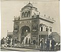 Photograph taken in the erstwhile Jind State
 Stamp of the Jind State. Edward VII, 1905


_of_the_erstwhile_Jind_State_during_the_reign_of_Maharaja_Raghubir_Singh.jpg)


See also
Notes
- Rajbir's other son Satbir Singh also claims to have been coroneted.
- 1931-1941: Including Ad-Dharmis
References
External links
Wikiwand - on
Seamless Wikipedia browsing. On steroids.
Remove ads