Top Qs
Timeline
Chat
Perspective
Kachaghakaberd
Fortress in Nagorno-Karabakh From Wikipedia, the free encyclopedia

Remove ads
Kachaghakaberd (Armenian: Կաչաղակաբերդ, Azerbaijani: Qaxaç qalası) is a mountain-top fortress located between the villages of Kolatak and Khndzristan, in Khojaly District of Azerbaijan.[1]


The Janapar Trail runs very near to the fortress. A short side trail takes to the top of the fortress.
Remove ads
Etymology

Kachaghakaberd is translated from Armenian as magpie's fortress, a combination of the words կաչաղաք (kachaghak, designating the bird magpie) and բերդ (berd, meaning fortress).[2][3]
Architecture
The fortress was an important fortification of the medieval Armenian Principality of Khachen that thrived in the High Middle Ages,[4] and is located at a height of more than 1700 meters, surrounded by vertical limestone cliffs with the heights of 50–60 meters, has a hard-to-reach entrance from the southern side of the fortress. During its history no one could ever storm the fortress. Parts of the defensive walls remain standing.[5]
The territory of the fortress occupies a large area, though it seems small. Many rooms, secret passages cut into the cliffs, and special loopholes for throwing stones at enemies are inside its territory.[3] The water supply problem was solved by a unique method: two rock-cut reservoirs to store rain and melt-water are in the center of the fortress. Fresh water was brought from a spring at the foot of the mountain.[2]
Remove ads
Gallery
 View of the tower
 View from the tower

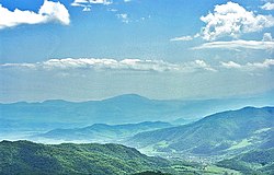 View of Kolatak village from the tower


See also
References
Wikiwand - on
Seamless Wikipedia browsing. On steroids.
Remove ads