Top Qs
Timeline
Chat
Perspective
Kirvi
From Wikipedia, the free encyclopedia

Remove ads
Kirvi is a mountain in Suðuroy,[1] near the village Lopra. Kirvi is 236m high and its shape resembles that of a pyramid. The mountain is visible from the villages Lopra. The top of the mountain is called Kirviskollur. The mountain is located in the municipality of Sumba.

Geology
Kirvi, like much of Suðuroy, is formed from volcanic basalt layers, a result of ancient volcanic activity that shaped the Faroe Islands millions of years ago during the Paleogene period. The mountain’s relatively steep, pointed profile suggests slower erosion compared to surrounding formations, contributing to its iconic pyramid-like appearance.
Nearby Landmarks
Kirvi is located not far from several notable sites:
Beinisvørð, one of the highest sea cliffs in Suðuroy (470 meters), lies to the northwest and offers dramatic views over the ocean.
The village of Sumba, the southernmost settlement in the Faroe Islands, is within the same municipality and known for its rugged beauty and cultural events.
Akraberg, the southern tip of Suðuroy, hosts a lighthouse and historical ruins and is often visited in combination with a hike up Kirvi.
Remove ads
Gallery
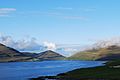 Kirvi seen from Porkeri
 Kirvi, right the cliff Beinisvørð
 Kirvi is in the center of this photo
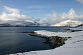


References
External links
Wikiwand - on
Seamless Wikipedia browsing. On steroids.
Remove ads