Top Qs
Timeline
Chat
Perspective
Ko Kut district
District in Trat, Thailand From Wikipedia, the free encyclopedia

Remove ads
Ko Kut (Thai: เกาะกูด, pronounced [kɔ̀ʔ kùːt]) is a district (amphoe) of Trat province, eastern Thailand, consisting of a group of islands. With a population of 2,894 in 2011, it is the least populous of all of Thailand districts.
Remove ads
History
Originally, the area of the district was part of the sub-district (tambon) Ko Chang, Laem Ngop district. In 1952, the sub-district Ko Mak was established to cover the whole island, at that time subdivided into four villages (mubans).[1] In 1980, three villages of Ko Mak were split off to create the Ko Kut sub-district.[2] On 1 April 1990, the government upgraded tambon Ko Kut together with tambon Ko Mak to a minor district (king amphoe).[3]
The Thai government on 15 May 2007 upgraded all 81 minor districts to full districts.[4] With publication in the Royal Gazette on 24 August, the upgrade became official.[5]
As local government entities, the two tambon administrative organizations (TAO) were created in 2003 and 2004 respectively. The Tambon Council Ko Kut was upgraded to a TAO in 2003,[6] and Ko Mak in 2004.[7]
Remove ads
Geography
The largest island in the district, Ko Kut, is a major island dotted with seaside villages and coconut plantations. It is about 60 minutes from the mainland by speedboat.
Administration
The district is divided into two sub-districts (tambons), which are further subdivided into eight villages (mubans). There are two tambon administrative organizations (TAO), one for each sub-district.
Gallery
 Ko Kut, Laem Ao Yai
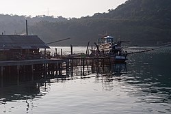
 Ko Kut, Ao Bang Bao
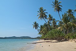 Ko Mak, Palm beach
 Ko Mak


,_Thailand,_Palms_on_the_beach_2.jpg)
,_Thailand,_Western_beach,_Gulf_of_Thailand.jpg)
References
External links
Wikiwand - on
Seamless Wikipedia browsing. On steroids.
Remove ads