Top Qs
Timeline
Chat
Perspective
Kopargaon taluka
Tehsil in Maharashtra, India From Wikipedia, the free encyclopedia
Remove ads
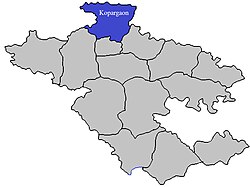
Kopargaon taluka is a taluka in Shirdi subdivision of Ahmednagar district in Maharashtra state of India.[1]
Remove ads
Area
The table below shows area of the taluka by land type.[2]
Villages
There are around 79 villages in Kopargaon taluka. For a list of villages see Villages in Kopargaon taluka. Major villages include Karanji bk, Kolapewadi, Manjur, Chas Nali, Sanwaster, Pohegaon, Dhamori, Dauch Khurd, Sangvi Bhusar, and Rawanda.
Population
Kopargaon taluka has a population of 302,452 according to the 2011 census. Kopargaon had a literacy rate of 69.75% and a sex ratio of 942 females per 1000 males. 65,273 (21.58%) lived in urban areas. Scheduled Castes and Scheduled Tribes make up 13.36% and 11.37% of the population respectively.[4]
At the time of the 2011 Census of India, 88.86% of the population in the district spoke Marathi, 5.26% Hindi and 3.01% Urdu as their first language.[5]
Rainfall
The Table below details rainfall from 1981 to 2004.[6]
See also
References
Wikiwand - on
Seamless Wikipedia browsing. On steroids.
Remove ads


