Top Qs
Timeline
Chat
Perspective
Kouhu
Rural township From Wikipedia, the free encyclopedia
Remove ads
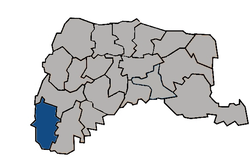
Kouhu Township (Chinese: 口湖鄉; pinyin: Kǒuhú Xiāng) is a rural township in Yunlin County, Taiwan. It is known for seafood products such as red algae, eel, and karasumi.[2]
Remove ads
Geography

It has a population total of 24,882 and an area of 80.4612 square kilometers, including a section of coastline bordering the Taiwan Strait.
History
Owing to the existence of a large lagoon shaped like an elephant's trunk in the area, Kouhu was known as Xiangbihu (Elephant Trunk Lake) in the late Ming and Qing periods.[3]
Kouhu's coastal waters were traditionally used in oyster farming, but in 1991 they were zoned for offshore industrial use.[4]
Administrative divisions
The township comprises 21 villages: Chenglong, Dinghu, Gangtung, Gangxi, Guogang, Houcuo, Hukou, Hutung, Jinghan, Keliao, Kouhu, Luntung, Lunjhong, Pubei, Punan, Shueijing, Sialun, Siecuo, Taizih, Wubei, and Wunan.
Infrastructure
Kouhu is one of the areas proposed by the Taiwan Power Company for an underground electricity cable connecting it with Jianshan Village in Penghu's Huxi Township.[5]
Festivals
- Qian Shui Che Zhuang Festival[6]
Tourist attractions
Transportation
- Provincial Highway 61
- Provincial Highway 17 (Taiwan)
- County Highway 164
Climate
Remove ads
See also
References
External links
Wikiwand - on
Seamless Wikipedia browsing. On steroids.
Remove ads


