Top Qs
Timeline
Chat
Perspective
Krottenkopf
From Wikipedia, the free encyclopedia

Remove ads
The Krottenkopf (German pronunciation: [ˈkʁɔtənˌkɔpf]), 2,086 metres/6,844 ft, is a peak in the Ester Mountains and the highest mountain in the Bavarian Prealps. It lies within the Bavarian district of Garmisch-Partenkirchen.

Remove ads
Location and climbing options
It lies in the westernmost part of the Bavarian Prealps in the Ester Mountains near the town of Garmisch-Partenkirchen. Immediately below and a half an hour from the summit is the Weilheimer Hut (1,955 metres/6,414 ft), the highest Alpine Club hut in the Bavarian Prealps.
There are four climbing options:
- From Oberau a very steep climb, the Oberauer Steig, follows narrow mountain paths via the Frickenboden and later runs past the Bischof mountain, which is also over 2,000 metres high, but less well known. This climb requires about 4 hours.
- From Klais another path runs via the Krüner Alm (1,620 metres/5,310 ft) and the Michelfeld
- From Garmisch-Partenkirchen and Farchant the route goes via the Esterbergalm taking about 4½ hours to reach the top of the Krottenkopf.
- In addition, there is the even longer climb from Eschenlohe past the 1,922-metre/6,306 ft Hohe Kisten to the summit.
Remove ads
Gallery
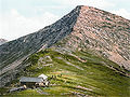 The Krottenkopf around 1900
 View from the Krottenkopf to the Kareck around 1900
 View from Heimgarten. Foreground: the Heimgarten Hut


See also
References
External links
Wikiwand - on
Seamless Wikipedia browsing. On steroids.
Remove ads