Top Qs
Timeline
Chat
Perspective
Kuqa, Xinjiang
County-level city in Xinjiang, China From Wikipedia, the free encyclopedia

Remove ads
Kuqa[b] (/ˈkuːtʃə/ KOO-chə) is a county-level city in Aksu Prefecture, Xinjiang Uyghur Autonomous Region, China. It was once the homeland of the ancient Buddhist Kingdom of Kucha.
.png)


Remove ads
History
Summarize
Perspective
The archaeological excavation of Neolithic cultural sites, such as the Haradun site (Chinese: 龟兹故城), indicates that ancient human activity occurred in the land of Kuche as early as 12,000 years ago.[7][8]
According to the Book of Han (completed in 111 CE), Kucha was the largest of the "Thirty-six Kingdoms of the Western Regions", with a population of 81,317, including 21,076 persons able to bear arms.[9]: 156
In 630, Xuanzang, a well-known Chinese Buddhist monk, scholar, traveler and translator visited Kucha during the Early Tang period.[10]
In the book "Hudud ul-'alam min al-mashriq ila al-maghrib", written in 982 by an unknown Arab or Persian writer, and presented to Abu'l Haret Muhammad, the ruler of Guzgan, the following is written regarding Kucha:
"Kucha is located on the Chinese border and belongs to China, but the indigenous people, Dokuzoguzes, at times are engaged in raids and looting. This city has many advantages."
Mirza Muhammad Haidar Dughlat, a military general, in his historical book Tarikh-i-Rashidi used the word "Kūsān" for Kucha.
Mahmud Kashgari, in his Compendium of Turkic Languages (Divân-ı Lügati't-Türk), wrote the following about Kucha: "It is one of the cities built by Zülqarnayin (Alexander the Macedonian)."[11] He also wrote that Kucha was a Uyghur town.[12]
.jpg)
In 1758, the Qing Dynasty took control of the area, and the Chinese character name 'Kuche' (庫車) was made the name of the area.[13] Kuqa was formed as a county in 1913,[14] inside the fourth administrative district of Xinjiang Province.[15][16] In 1930, Xinjiang was partitioned into 12 districts to establish Tokesu County.[17]
On December 20, 2019, Kuqa County was disestablished and Kuqa City was created.[18]
Ancient Buddhist kingdom in Kuqa
Monasteries
- Ta-mu had 170 priests.
- Around Che-hu-li, on a hill north of the city of Po-shan, there were 50 or 60 monks.
- Another Monastery was founded by King Wen-Su (Uch-Turfan) and had 70 monks.
Convents
There were two convents in A-li (Avania).
- Liun-jo-kan: 50 nuns
- A-li-po: 30 nuns
Another monastery, Tsio-li, north of Kucha and a famous place where Kumārajīva's mother Jīva retreated.

Priests
Po-Yen
Known as Po-Yen, a priest from the royal family who traveled to the Chinese capital Luoyang between 256 and 260 BC. He translated six Buddhist texts into Chinese within the year 258 BC.
Po-Po-Śrīmitra
Po-Po-Śrīmitra is another priest from Kuqa who traveled Southern China between 307 and 312 BC and translated three Buddhist texts.
Po-Yen
A second Buddhist priest from Kuqa, known as Po-Yen, also went to Liangzhou (present-day Wuwei district in Gansu). Although not so well known in China, he translated many texts.[19]
Remove ads
Climate
Summarize
Perspective
Geography
_Kucha_mint._Dually_dated_AH_1281_and_RY_2_(AD_1864)._Legend_Said_Ghazi_Rashidin_Khan._Ithneen_in_Arabic._Reverse_Zarb_dar_al-sultanat_Kuqa,_1281_in_Arabic.jpg)
The city is located at the southern periphery of the Tian Shan range, the northern portion of the Tarim Basin, and the centre of the autonomous region. It occupies part of the northeastern portion of Aksu Prefecture, bordering Xinhe County, Xayar County, and Luntai County, Heiing County, and Lopnur County in Bayingolin Mongol Autonomous Region.
Kuqa has a continental desert climate (Köppen BWk), with an average annual precipitation of 74.6 millimetres (2.94 in), a majority of which occurs in summer. The monthly 24-hour average temperature ranges from −7.2 °C (19.0 °F) in January to 25.3 °C (77.5 °F) in July, and the annual mean is 11.29 °C (52.3 °F). The frost-free period lasts for 266 days on average.[citation needed] With monthly percent possible sunshine ranging from 54% in March to 69% in September and October, sunshine is abundant and the city receives 2,712 hours of bright sunshine annually.
Remove ads
Administrative divisions
Summarize
Perspective

Kuqa has 4 subdistricts, 8 towns, 6 townships and one other area under its administration:[23][24][1][25]
Economy
Agricultural products include wheat, corn, rice, cotton as well as pears, apricots, melons, grapes, pomegranates, figs, etc. Specialty products include Sanbei Sheep (三北羊) lambskin, white apricots and thin-shelled walnuts. Mineral resources include oil and coal. Industries include coal mining, tractor manufacturing and repair, construction and processing for non-staple foods.[30]
As of 1885[update], there was about 99,200 acres (654,476 mu) of cultivated land in Kuqa.[31]
Remove ads
Demographics
As of 2015, 440,125 of the 492,535 residents of Kuqa County were Uyghur, 49,021 were Han Chinese and 3,389 were from other ethnic groups.[32]
As of 2002[update], the county had a population of 450,000.[citation needed]
As of 1999, 89.93% of the population of Kuqa County were Uyghur and 9.49% of the population was Han Chinese.[33]
Remove ads
Transportation
Kuqa is served by China National Highway 217, China National Highway 314,[30] the Southern Xinjiang Railway and Kuche Qiuci Airport.
Kuqa Town

Kuqa is also the name of the central town (Chinese: 库车镇), located in the easternmost area of Kuqa. It is the second largest town of Aksu Prefecture. Its area size is 14,528.74 square meters and population 470,600, composed of fourteen peoples including the Uyghurs, Hans, Huis, and Mongols. Kuqa is a thriving town of oil and natural gas development of the Tarim Basin, and of tourism, as it was once the homeland of the ancient Buddhist Kingdom of Kucha.[citation needed] Its tourist attractions are:
Remove ads
Notable persons
- Qurban Mamut, former editor-in-chief of the official Xinjiang Cultural Journal (《新疆文化》) and detainee in the Xinjiang internment camps[34][35]
Historical maps
Historical English-language maps including Kuqa:
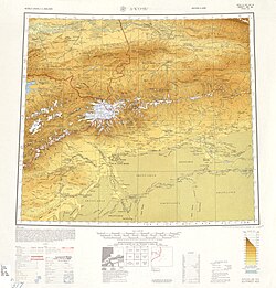 Map including Kuqa (labeled as K'U-CH'E (KUCHA)) and surrounding region from the International Map of the World (AMS, 1950)[c]
 Map including Kuqa (labeled as Kuga/ Kuche/ Kuqaxian) (DMA, 1981)
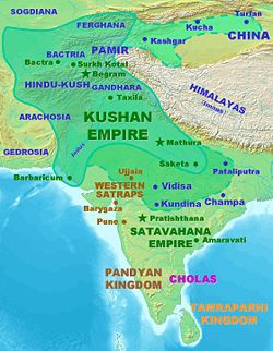 Kucha in the Kushan Empire under Kanishka the Great
_-_panoramio.jpg)


Notes
- Locals in Xinjiang frequently observe UTC+6 (Xinjiang Time), 2 hours behind Beijing.
Remove ads
References
External links
Wikiwand - on
Seamless Wikipedia browsing. On steroids.
Remove ads