Top Qs
Timeline
Chat
Perspective
Laguna Caldera
Underwater volcanic caldera in Laguna de Bay, Philippines From Wikipedia, the free encyclopedia

Remove ads
Laguna Caldera is a potentially active volcanic caldera and a geographical depression in Rizal, Philippines. It is broadly elliptical in shape, with dimensions of 20 by 10 km. It has a summit (Mount Sembrano) elevation of 743 metres (2,438 ft).[1] The caldera forms the middle lobe of Laguna de Bay, bound by the Morong Peninsula and Talim Island to the west, and the Jalajala Peninsula to the east.
This article needs additional citations for verification. (February 2020) |
.svg)
The caldera may have formed in two stages about 1 million and 27,000-29,000 years ago, during which time at least two major explosive eruptions took place. It is unknown when the Laguna Caldera last erupted but it may have been active during the Holocene.[1] Deposits from the caldera form thick ignimbrite sheets in Rizal, Metro Manila, Laguna, and Bulacan.[2] Remnants of volcanic activity include undated maars at the southern end of Talim Island and a solfatara field on nearby Mount Sembrano.[1] Given the current shape of the lake and the caldera, and how it was once connected to Manila Bay as evidenced by its ground drill geology, its formation is speculated to have been a result of an even earlier cataclysmic eruption, pointing to a possibility that it was once a volcano of considerable elevation that exploded, similar to Krakatoa.[3] The Pleistocene Diliman tuff formation in Metro Manila might be related to it though there are slight variations in composition.[4]
Remove ads
Photographs
 Laguna Caldera looking east
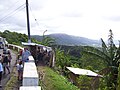 Laguna Caldera looking south-east
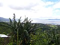 Laguna Caldera looking south
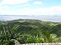 Laguna Caldera looking west


See also
References
Wikiwand - on
Seamless Wikipedia browsing. On steroids.
Remove ads