Top Qs
Timeline
Chat
Perspective
Landgraben (Mecklenburg-Vorpommern)
River in Germany From Wikipedia, the free encyclopedia
Remove ads
Landgraben is a river of Mecklenburg-Vorpommern, Germany. It is 22.5 km (14.0 mi) long.[1]
This article needs additional citations for verification. (April 2025) |
You can help expand this article with text translated from the corresponding article in German. (September 2011) Click [show] for important translation instructions.
|

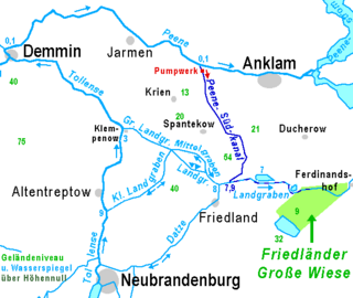
It forms a pseudobifurcation: its water west of Friedland flows towards the Großer Landgraben and the Tollense, and its water east of Friedland flows towards the Zarow, which flows into the Szczecin Lagoon. Its main tributary is the northflowing bifurcation of the Datze River, almost in the middle of its bed.
The approximate meaning of Landgraben is "Border Canal".[citation needed] For several centuries it was part of the border between Mecklenburg and Pomerania. The Landgraben drains one of the broad glacial valleys of Mecklenburg-Vorpommern. In these valleys, there is no strict discrimination[clarification needed] between natural and artificial courses of water.
Remove ads
See also
References
Wikiwand - on
Seamless Wikipedia browsing. On steroids.
Remove ads


