Top Qs
Timeline
Chat
Perspective
Langenes Municipality
Former municipality in Nordland, Norway From Wikipedia, the free encyclopedia
Remove ads
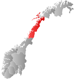
Langenes is a former municipality in Nordland county, Norway. The municipality, which existed from 1919 until 1964, encompassed the western shore of the Gavlfjorden in what is now Øksnes Municipality. It is located on the northern end of the large island of Langøya in the Vesterålen archipelago. The administrative centre was in the village of Stø, just east of the Langenes Church in the northern part of the municipality.[6]
Remove ads
General information
Summarize
Perspective
The municipality of Langenes was established on 1 July 1919 when the northeastern part of Øksnes Municipality was split off from Øksnes to form the new municipality. Initially, Langenes had a population of 1,085. During the 1960s, there were many municipal mergers across Norway due to the work of the Schei Committee. On 1 January 1963, the Holm area along the Gavlfjorden (population: 65) was transferred from Langenes Municipality to Sortland Municipality. On 1 January 1964, the rest of Langenes (population: 2,037) was merged back together with Øksnes Municipality. Prior to the merger, Langenes had 2,037 residents.[7]
Name
The municipality is named after the old Langenes farm (Old Norse: Langøyjarnes) since the first Langenes Church was built there. The first element is lang which means "long", here referring to the island, Langøya on which the municipality was located. The island's name, Langøya, is directly translated as "the long island". The last element is nes which means "headland". The municipality was located on the northernmost peninsula on the island thus the name Langenes means the "headland on Langøya".[8]
Churches
The Church of Norway had one parish (sokn) within Langenes Municipality. At the time of the municipal dissolution, it was part of the Øksnes prestegjeld and the Vesterålen prosti (deanery) in the Diocese of Sør-Hålogaland.[9]
Remove ads
Geography
Langenes Municipality was located on the island of Langøya, along with many other smaller islets and skerries just off shore. Øksnes Municipality was located to the west, Sortland Municipality was located to the south, and Bjørnskinn Municipality was located to the east, across the Gavlfjorden, on the island of Andøya. The highest point in the municipality is the 762.46-metre (2,501.5 ft) tall mountain Snøkolla, located on the border with Øksnes Municipality.[1]
- Area near Langenes Church
- Harbour at Stø
- View of the village of Alsvåg
Remove ads
Government
Summarize
Perspective
While it existed, Langenes Municipality was responsible for primary education (through 10th grade), outpatient health services, senior citizen services, welfare and other social services, zoning, economic development, and municipal roads and utilities. The municipality was governed by a municipal council of directly elected representatives. The mayor was indirectly elected by a vote of the municipal council.[10] The municipality was under the jurisdiction of the Hålogaland Court of Appeal.
Municipal council
The municipal council (Herredsstyre) of Langenes Municipality was made up of representatives that were elected to four year terms. The party breakdown of the final municipal council was as follows:
Mayors
The mayor (Norwegian: ordfører) of Langenes Municipality was the political leader of the municipality and the chairperson of the municipal council. Here is a list of people who have held this position:
- 1919–1919: S. Skog[17]
- 1920–1922: Lars Olson Standahl[18]
- 1923–1925: Lorents Bendik Olsen Sæther[19]
- 1925–1928: S. Skog[20]
- 1928–1934: Lorents Bendik Olsen Sæther[21]
- 1935–1943: L.H. Nielsen (H)[22]
- 1943–1945: Olav Meløy[23]
- 1945–1945: Kristian Holm[24]
- 1946–1955: Julius Kristian Pettersen Meløy (KrF)[25]
- 1955–1963: Otto Holm (Ap)[26]
Remove ads
See also
References
Wikiwand - on
Seamless Wikipedia browsing. On steroids.
Remove ads


