Top Qs
Timeline
Chat
Perspective
List of Colorado Scenic and Historic Byways
From Wikipedia, the free encyclopedia

Remove ads
Colorado Scenic and Historic Byways[1][2][3] are highway and backroad routes in the U.S. state of Colorado designated by the Colorado Scenic and Historic Byways Commission[4] for their scenic and historic values. These byways follow existing roads or highways and are signed with a Colorado blue columbine (the Colorado state flower) logo denoting the route. The Colorado Scenic and Historic Byways Program was established in March 1989, and is one of the oldest state scenic byway programs. Since 1989, the program has designated 26 Colorado Scenic and Historic Byways with 2,585 miles (4,160 km) of roadway, 4,459 miles (7,176 km) including scenic byway extensions in adjacent states.

In addition to state scenic byway designations, four federal agencies designate specific types of scenic byways:
- The Federal Highway Administration designates National Scenic Byways and All-American Roads (the highest designation.)
- The National Park Service administers congressionally authorized National Parkways.
- The United States Forest Service designates and manages National Forest Scenic Byways in National Forests and National Grasslands.
- The Bureau of Land Management designates and manages Back Country Byways in areas managed by the BLM.
The Colorado Scenic and Historic Byways Commission works closely with these four federal agencies to select scenic and historic byways that meet federal criteria. Of the 26 current Colorado designated byways, 21 already have a federal designation as well. These include two All-American Roads,[5] 11 National Scenic Byways,[5] ten National Forest Scenic Byways,[6] and three Back Country Byways.[7]
The 13 combined All-American Roads and National Scenic Byways in Colorado are currently the most of any state. Five Colorado byways currently have two federal designations. The San Juan Skyway Scenic and Historic Byway is both an All-American Road and a National Forest Scenic Byway. The Grand Mesa National Scenic Byway, the Highway of Legends National Scenic Byway, and the Silver Thread Scenic and Historic Byway are both National Scenic Byways and National Forest Scenic Byways. The Gold Belt Tour Scenic and Historic Byway is both a National Scenic Byway and a Back Country Byway.
Remove ads
Colorado Scenic and Historic Byways Commission
Summarize
Perspective
The Colorado Scenic and Historic Byways Commission[8] was established in 1989 to administer the Colorado Scenic and Historic Byways Program. The Governor of Colorado appoints the members of the commission.[9]
The program is a statewide partnership intended to provide recreational, educational, and economic benefits to residents and visitors by designating, interpreting, protecting, and promoting a system of outstanding touring routes in Colorado.
Proposed routes are nominated by local communities and approved by the Commission, but byway development is managed at the local level.
The Commission works with:
- State agencies including the Colorado Department of Transportation, the Colorado Department of Natural Resources, the Colorado Department of Local Affairs, and the Colorado Tourism Office;
- Federal agencies including the National Park Service, the United States Forest Service, the Bureau of Land Management, and the Federal Highway Administration;
- County and municipal governments;
- Local byways organizations, community organizations, interested individuals, and public and private resources;
- Scenic byway programs in the seven adjacent states of Wyoming, Nebraska, Kansas, Oklahoma, New Mexico, Arizona, and Utah.
The Commission uses the following criteria to select potential byways:
- The proposed Scenic and Historic Byway must possess unusual, exceptional, and distinctive scenic, recreational, historical, educational, scientific, geological, natural, wildlife, cultural, or ethnic features.
- The proposed Scenic and Historic Byway must be suitable for the prescribed types of vehicular use.
- The proposed Scenic and Historic Byway must be an existing route and have legal public access.
- The proposed Scenic and Historic Byway must have strong local support and proponents must demonstrate coordination with relevant agencies.
- The proposed Scenic and Historic Byway must be accompanied by a conceptual plan, as specified in the nomination process.
The Commission favors proposed byways with both scenic and historic features. Byways with predominantly scenic features are labeled a "Scenic Byway" or a "National Scenic Byway" if also an All-American Road or a National Scenic Byway. Byways with predominantly historic features are labeled a "Historic Byway". Byways with both strong scenic and historic features are labeled a "Scenic and Historic Byway".
Remove ads
List
Remove ads
Gallery


 The Flat Tops Wilderness from the Flat Tops Trail Scenic Byway
 Bicycling on the Gold Belt Tour Scenic and Historic Byway
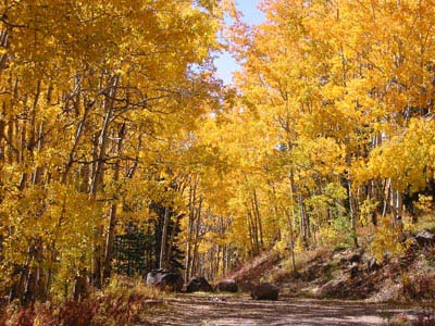 Autumn along the Grand Mesa Scenic Byway


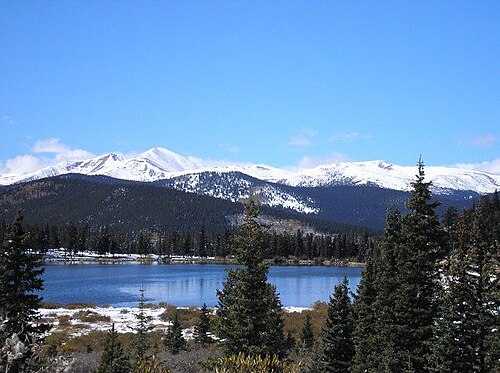 Echo Lake along the Mount Blue Sky Scenic Byway
 The Indian Peaks Wilderness from the Peak to Peak Scenic Byway


 Autumn along the West Elk Loop Scenic and Historic Byway
.jpg)
.jpg)


.jpg)


See also
Notes
- Capitol City is a ghost town that was once proposed to replace Denver as the state capital of Colorado. The foundation of the would-be state capitol building remains.
- Most of the Alpine Loop Back Country Byway is on unimproved roads that require a high-clearance four-wheel-drive vehicle.
- Cameron Pass has an elevation of 10,276 feet (3,132 m).
- The Dinosaur Diamond National Scenic Byway has 134 miles (216 km) of Colorado roadway[22] and the Dinosaur Diamond Prehistoric Highway has 328 miles (528 km) of Utah roadway.[23]
- History Colorado operates the El Pueblo History Museum on the Frontier Pathways National Scenic Byway.
- The Gold Belt Tour Scenic and Historic Byway has three alternate routes. Vehicles over 25 feet (7.6 m) long are not allowed on the Phantom Canyon Road. The Shelf Road may require a high-clearance four-wheel-drive vehicle. The High Park Road is paved and does not have restrictions. The Garden Park Fossil Area on the Shelf Road is a National Natural Landmark.
- Guanella Pass has an elevation of 11,669 feet (3,557 m).
- The Spanish Peaks on the Highway of Legends National Scenic Byway are a National Natural Landmark. Both East Spanish Peak at elevation 12,688 feet (3,867 m) and West Spanish Peak at elevation 13,631 feet (4,155 m) are higher than any point in the United States farther east.
- Cumbres Pass has an elevation of 10,022 feet (3,055 m).
- The Cumbres and Toltec Scenic Railroad on Los Caminos Antiguos Scenic and Historic Byway is a National Historic Landmark. The Town of San Luis (San Luis de la Culebra) is the oldest town in Colorado. History Colorado operates the Fort Garland Museum.
- The Mount Blue Sky Scenic Byway on Colorado State Highway 5 is the highest paved road in North America with its upper terminus at 14,140 feet (4,310 m) elevation near the summit of Mount Blue Sky at 14,267 feet (4,349 m) elevation. Summit Lake on Mount Blue Sky is a National Natural Landmark. Vehicles over 30 feet (9.1 m) long are not allowed on State Highway 5, but are allowed on State Highway 103 which reaches its highest elevation of 11,020 feet (3,359 m) at Juniper Pass.
- Coal Bank Pass has an elevation of 10,640 feet (3,240 m).
- Molas Pass has an elevation of 10,910 feet (3,330 m).
- Red Mountain Pass has an elevation of 11,018 feet (3,358 m).
- Lizard Head Pass has an elevation of 10,222 feet (3,116 m).
- The Santa Fe Trail Scenic and Historic Byway has 188 miles (303 km) of Colorado roadway[62] and the Santa Fe Trail Scenic Byway has 381 miles (613 km) of New Mexico roadway.[63]
- The Silver Thread Scenic and Historic Byway crosses the Continental Divide on Spring Creek Pass at 10,898 feet (3,322 m) elevation, but reaches its highest elevation of 11,530 feet (3,514 m) at Slumgullion Summit. The Slumgullion Earthflow is a National Natural Landmark.
- The Top of the Rockies National Scenic Byway showcases the two highest peaks of the Rocky Mountains: Mount Elbert at elevation 14,440 feet (4,401.2 m) and Mount Massive at elevation 14,428 feet (4,398 m). The byway crosses the Continental Divide at Independence Pass at 12,095 feet (3,687 m) elevation, Fremont Pass at 11,318 feet (3,450 m) elevation, and Tennessee Pass at 10,424 feet (3,177 m) elevation. The gold mining ghost town of Independence is a historic townsite 2.2 miles (4 km) west of Independence Pass. The Leadville Historic District is a National Historic Landmark. History Colorado operates the Healy House Museum and Dexter Cabin in Leadville. The City of Leadville is the highest incorporated city in North America with a downtown elevation of 10,152 feet (3,094 m).
- The Tracks Across Borders Scenic and Historic Byway has 89 miles (143 km) of Colorado roadway[75] and the Narrow-Gauge Scenic Byway has 9.9 miles (16 km) of New Mexico roadway.[76]
- The Trail of the Ancients Scenic and Historic Byway has 116 miles (187 km) of Colorado roadway,[78] the Trail of the Ancients National Scenic Byway has 366 miles (589 km) of Utah roadway,[79] the Kayenta-Monument Valley Scenic Road has 26 miles (42 km) of Arizona roadway,[80] the Dine' Tah "Among the People" Scenic Road has 100.3 miles (161 km) of Arizona roadway,[81] and the Trail of the Ancients Scenic Byway has 662.4 miles (1,066 km) of New Mexico roadway.[82]
- Yucca House National Monument is undeveloped.
- This 282-mile (454 km) Four Corners loop is only a portion of the entire 1,271-mile (2,045 km) Trail of the Ancients Scenic and Historic Byway system.
- The Trail Ridge Road/Beaver Meadow National Scenic Byway on U.S. Route 34 is the highest continuous paved highway in North America with its high point at 12,183 feet (3,713 m) elevation near Fall River Pass. The highway crosses the Continental Divide at the much lower Milner Pass at 10,759 feet (3,279 m) elevation. The Beaver Meadows Visitor Center is a National Historic Landmark.
- Kebler Pass has an elevation of 10,007 feet (3,050 m).
Remove ads
References
External links
Wikiwand - on
Seamless Wikipedia browsing. On steroids.
Remove ads