Top Qs
Timeline
Chat
Perspective
List of Indian states and union territories by highest point
From Wikipedia, the free encyclopedia
Remove ads
This is the alphabetical list of the highest points of the Indian states and union territories.
States
Summarize
Perspective
More information States, Peak ...
| States | Peak | Range/Region | Height | Coordinates | Source | |
|---|---|---|---|---|---|---|
| In m | In ft | |||||
| Sikkim | Kangchenjunga | Eastern Himalayas | 8,586 | 28,169 | 27.704°N 88.148°E / 27.704; 88.148 | Kangchenjunga lies on the India–Nepal border. It is the highest mountain peak located in India and the third highest mountain peak in the world after Mount Everest and K2.[1] |
| Uttarakhand | Nanda Devi | Garhwal Himalayas | 7,817 | 25,646 | 30.376°N 79.970°E / 30.376; 79.970 | Nanda Devi is the highest mountain peak located entirely within India. It is the highest peak in the Garhwal Himalayas.[2] |
| Arunachal Pradesh | Kangto | Eastern Himalayas | 7,060 | 23,160 | Kangto lies on the Line of Actual Control between India and China. | |
| Himachal Pradesh | Reo Purgyil | Western Himalayas | 6,813 | 22,362 | 31.884°N 78.735°E / 31.884; 78.735 | Reo Purgyil lies on the Line of Actual Control between India and China. |
| Nagaland | Mount Saramati | Naga Hills section of the Patkai Range | 3,841 | 12,602 | 25.742°N 95.033°E / 25.742; 95.033 | Mount Saramati lies on the India–Myanmar border. It is the highest peak in the Patkai Range.[3] |
| West Bengal | Sandakphu | Singalila Ridge section of the Eastern Himalayas. | 3,665 | 12,024 | 27.106°N 88.002°E / 27.106; 88.002 | Sandakphu lies on the India–Nepal border. It is the highest peak in the Singalila Ridge.[4] |
| Manipur | Mount Tempü | Barail Range section of the Patkai Range | 2,994 | 9,823 | 25.531°N 94.085°E / 25.531; 94.085 | Mount Tempü lies on the inter-state border between Nagaland and Manipur. [5][6] |
| Kerala | Anamudi | Anaimalai Hills section of the Western Ghats | 2,695 | 8,842 | 10.170°N 77.061°E / 10.170; 77.061 | Anamudi is the highest mountain peak in the Western Ghats and highest in India outside the Himalayas. It is the highest peak in the Anaimalai Hills.[7] |
| Tamil Nadu | Doddabetta | Nilgiri Mountains section of the Western Ghats | 2,636 | 8,648 | 11.401°N 76.736°E / 11.401; 76.736 | Doddabetta is the highest peak in the Nilgiri Mountains.[8] |
| Mizoram | Phawngpui | Lushai Hills section of the Patkai Range | 2,165 | 7,103 | 22.6315°N 93.0388°E / 22.6315; 93.0388 | Phawngpui is also known as Blue Mountain. It is the highest mountain peak in the Lushai Hills.[9] |
| Meghalaya | Shillong Peak | Khasi Hills section of the Shillong Plateau | 1,965 | 6,447 | 25.5316°N 91.8512°E / 25.5316; 91.8512 | Located in East Khasi Hills District. Shillong Peak is the highest peak in the Shillong Plateau.[10] |
| Assam | Unnamed peak | Cachar Hills section of the Karbi Anglong Plateau | 1,960 | 6,430 | 25.32135°N 93.4529°E / 25.32135; 93.4529 | Located in Dima Hasao District. It is the highest peak in the Karbi Anglong Plateau.[11] |
| Karnataka | Mullayyanagiri | Sahyadri Range section of the Western Ghats | 1,925 | 6,317 | 13.391°N 75.721°E / 13.391; 75.721 | Mullayyanagiri is the highest peak in the Sahyadri Range.[12] |
| Rajasthan | Guru Shikhar | Aravalli Range | 1,722 | 5,650 | 24.650°N 72.776°E / 24.650; 72.776 | Guru Shikhar is the highest peak in the Aravalli Range.[13] |
| Andhra Pradesh | Arma Konda | Eastern Ghats | 1,680 | 5,512 | 18.228°N 82.723°E / 18.228; 82.723 | Arma Konda is the highest peak in the Eastern Ghats.[14][15] |
| Odisha | Deomali | Eastern Ghats | 1,672 | 5,486 | 18.675°N 82.982°E / 18.675; 82.982 | [16] |
| Maharashtra | Kalsubai | Sahyadri Range section of the Western Ghats | 1,646 | 5,400 | 19.6003°N 73.711°E / 19.6003; 73.711 | [17] |
| Haryana | Karoh Peak | Morni Hills section of the Sivalik Hills | 1,499 | 4,918 | 30.7437°N 77.0769°E / 30.7437; 77.0769 | Karoh Peak is the highest peak in the Morni Hills.[18] |
| Jharkhand | Parasnath | Chota Nagpur Plateau | 1,382 | 4,482 | 23.9634°N 86.129°E / 23.9634; 86.129 | Parasnath is the highest peak in the Chota Nagpur Plateau.[19] |
| Madhya Pradesh | Dhupgarh | Satpura Range | 1,352 | 4,435 | 22.449°N 78.371°E / 22.449; 78.371 | Dhupgarh is the highest peak in the Satpura Range.[20] |
| Chhattisgarh | Nandiraj | Bailadila Range section of the Deccan Plateau | 1,276 | 4,186 | 18.6646°N 81.2258°E / 18.6646; 81.2258 | Located in Dantewada District. Nandiraj is the highest peak in the Bailadila Range.[21][22][23] |
| Gujarat | Girnar | Girnar Hills | 1,145 | 3,756 | 21.528°N 70.527°E / 21.528; 70.527 | Girnar is the highest peak in the Girnar Hills.[24] |
| Goa | Sonsogor | Western Ghats | 1,022 | 3,353 | 15.5232°N 74.2795°E / 15.5232; 74.2795 | Sonsogor lies on the inter-state border between Goa and Karnataka.[25] |
| Punjab | Unnamed peak | Naina Devi Range section of the Sivalik Hills | 1,000 | 3,281 | 31.259°N 76.601°E / 31.259; 76.601 | Located in Rupnagar District.[26] |
| Telangana | Doli Gutta | Deccan Plateau | 965 | 3,166 | 18°20′31″N 80°44′29″E | Doli Gutta lies on the inter-state border between Chhattisgarh and Telangana.[27] |
| Uttar Pradesh | Amsot Peak | Rajaji Range section of the Sivalik Hills | 957 | 3,140 | 30.3798°N 77.6865°E / 30.3798; 77.6865 | Located in Saharanpur District. Amsot Peak lies on the inter-state border between Uttarakhand and Uttar Pradesh. It is the highest peak in the Rajaji Range.[28] |
| Tripura | Betlingchhip | Jampui Hills section of the Lushai Hills | 930 | 3,051 | 23.8097°N 92.2609°E / 23.8097; 92.2609 | Betlingchhip is also known as Thaidawr. It is the highest peak in the Jampui Hills.[29] |
| Bihar | Someshwar Fort | Sivalik Hills | 880 | 2,887 | 27.3876°N 84.3055°E / 27.3876; 84.3055 | [30] |
Close
Remove ads
Union territories
More information Union Territory, Peak ...
| Union Territory | Peak | Range/Region | Height | Coordinates | Source | |
|---|---|---|---|---|---|---|
| In m | In ft | |||||
| Ladakh | Saltoro Kangri | Saltoro Mountains section of Karakoram | 7,742 | 25,400 | 35.399°N 76.849°E / 35.399; 76.849 | Saltoro Kangri lies on the Actual Ground Position Line between India and Pakistan on the Siachen Glacier. It is the highest peak in the Saltoro Mountains. The highest peak claimed by India as part of Ladakh is K2 which has the elevation of 8,611 m (28,251 ft). K2 is located in the Pakistan-administered territory of Gilgit-Baltistan.[31][32][33] |
| Jammu and Kashmir | Nun Peak | Western Himalayas | 7,135 | 23,409 | 33.9809°N 76.0205°E / 33.9809; 76.0205 | [34] |
| Andaman and Nicobar Islands | Saddle Peak | North Andaman Island | 732 | 2,402 | 13.1586°N 93.0058°E / 13.1586; 93.0058 | [35] |
| Chandigarh | Unnamed point near Khuda Ali Sher Village | Sivalik Hills | 479 | 1,572 | 30.7724°N 76.8204°E / 30.7724; 76.8204 | Located on the border between Punjab and Chandigarh.[citation needed] |
| Dadra and Nagar Haveli and Daman and Diu | Unnamed point near Bedpa Village | Western Ghats | 465 | 1,526 | 20.0802°N 73.2057°E / 20.0802; 73.2057 | Located in Dadra and Nagar Haveli District on the border between Dadra and Nagar Haveli and Daman and Diu and Maharashtra.[citation needed] |
| Delhi | Deheri | Delhi Ridge section of the Aravalli Range | 315 | 1,033 | 28.4108°N 77.2037°E / 28.4108; 77.2037 | Located in South Delhi District on the border between Delhi and Haryana.[citation needed] |
| Puducherry | Unnamed point near Chalakara Village | West Coast Hillocks | 67 | 219 | 11.7183°N 75.5317°E / 11.7183; 75.5317 | Located in Mahé District on the border between Puducherry and Kerala.[citation needed] |
| Lakshadweep | Unnamed point | Agatti Island | 15 | 49 | ||
Close
Remove ads
Gallery
 Kangchenjunga (8,586 m)
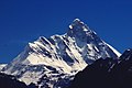 Nanda Devi (7,816 m)
 Saltoro Kangri (7,742m)
 Nun Kun (7,135 m)
 Kangto (7,090 m)
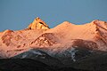 Reo Purgyil (6,816 m)
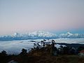 Sandakphu (3,636 m)
 Anamudi (2,695 m)
 Guru Shikhar (1,722 m)
 Kalsubai (1,646 m)


.jpg)


See also
References
Wikiwand - on
Seamless Wikipedia browsing. On steroids.
Remove ads
Remove ads