| Name |
Image |
Location |
Denomination/
Affiliation |
Grade |
Notes |
Refs |
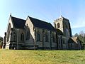
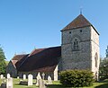
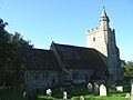
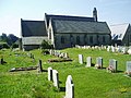
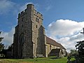
Alciston Church
(More images) |
 |
Alciston
50.8299°N 0.1368°E / 50.8299; 0.1368 (Alciston Church, Alciston) |
Anglican |
I |
Much 12th-century work remains in this isolated church; it had links to Battle Abbey at that time. Remnants of a Saxon apse are also visible. The flint building has a wooden belfry and a late-19th-century timber-framed roof. Restoration was carried out in 1853. The chancel is mostly 13th-century. |
[139][15]
[140][141] |
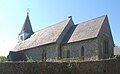
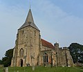
St Andrew's Church
(More images) |
 |
Alfriston
50.8066°N 0.1580°E / 50.8066; 0.1580 (St Andrew's Church, Alfriston) |
Anglican |
I |
This large cruciform church, known as the "Cathedral of the Downs", dates from about 1360 and has been only minimally altered: the spire was restored in 1905. The flintwork is extremely finely crafted. The lancet windows vary between two Gothic styles—Decorated and Perpendicular. Fittings include an Easter Sepulchre. |
[142][47]
[143][144]
[145] |
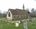
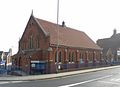
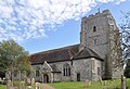
St Pancras' Church
(More images) |
 |
Arlington
50.8462°N 0.1902°E / 50.8462; 0.1902 (St Pancras' Church, Arlington) |
Anglican |
I |
A chiefly Anglo-Saxon flint church with some Early English and Decorated Gothic additions, this building has a 15th-century king post roof and faint remnants of wall murals. By 1850, the building was so dilapidated that it closed for restoration until 1893. Roman brickwork and remains of an earlier wooden and wattle-and-daub church have also been found. |
[145][146]
[11][147]
[148] |
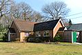
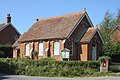
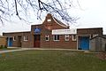
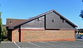
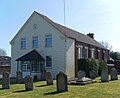
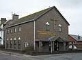
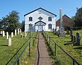
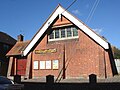
Bells Yew Green Chapel
(More images) |
 |
Bells Yew Green
51.1024°N 0.2969°E / 51.1024; 0.2969 (Bells Yew Green Chapel, Bells Yew Green) |
Countess of Huntingdon's Connexion |
– |
Situated very close to the Kent border, and associated with the former Emmanuel Chapel at Tunbridge Wells, this chapel is attached to a house. It was built by the Countess of Huntingdon's Connexion Trust in 1879 (although it was not registered for marriages until August 1983), and has a rendered exterior. |
[149][150]
[151][152]
[153] |
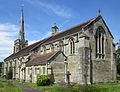
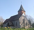
St Michael and All Angels Church
(More images) |
 |
Berwick
50.8239°N 0.1550°E / 50.8239; 0.1550 (St Michael and All Angels Church, Berwick) |
Anglican |
I |
This 12th-century church (with a much older font) has a famous set of wall murals—not contemporary with the building, but painted during World War II by Bloomsbury Group associates such as Duncan Grant and Vanessa Bell at the invitation of the Bishop of Chichester. Victorian restoration was prompted by the ruinous state of the church in the early 19th century. |
[154][155]
[16][156]
[157] |
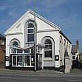
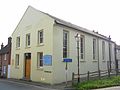
| Hope Strict Baptist Chapel |
 |
Blackboys
50.9490°N 0.1562°E / 50.9490; 0.1562 (Hope Strict Baptist Chapel, Blackboys) |
Strict Baptist |
– |
Built in 1875 and registered for marriages in April 1881, this red-brick Vernacular-style building is attached to a house. The walls are rendered. Since its inception it has catered for Gospel Standard Baptists. |
[137][61]
[158][159]
[160][161] |
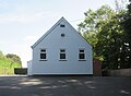
All Saints Church
(More images) |
 |
Blackham
51.1414°N 0.1405°E / 51.1414; 0.1405 (All Saints Church, Blackham) |
Anglican |
– |
Architect Lacy W. Ridge designed this Gothic Revival church in 1902. The west end of the stone building has an octagonal belfry on the roof, appearing to balance on a buttress. All windows are lancets. |
[61][162] |
| St John the Evangelist's Church |
 |
Bodle Street Green
50.9041°N 0.3466°E / 50.9041; 0.3466 (St John the Evangelist's Church, Bodle Street Green) |
Anglican |
– |
A church was erected in this hamlet in 1855, but there may have been an earlier chapel of ease (to Warbleton parish church) in the 1830s. Major Rohde Hawkins' original church burnt down in 1923, and Walter Tower designed a flint and stone Perpendicular Gothic Revival replacement with a wooden belfry. |
[71][163] |
| Ebenezer Strict Baptist Chapel |
 |
Bodle Street Green
50.9102°N 0.3439°E / 50.9102; 0.3439 (Ebenezer Strict Baptist Chapel, Bodle Street Green) |
Strict Baptist |
– |
An Independent Baptist congregation was founded here in 1835 by a Horsham-based preacher. The present chapel is aligned to the Gospel Standard movement and was built in 1864, although it was not registered for marriages until November 1988. It is timber-framed, partly weatherboarded and rendered, and has been extended several times. There is a gable above the entrance porch. |
[158][71]
[137][164]
[165][166]
[167] |
St George's Church
(More images) |
 |
Broad Oak
50.9762°N 0.2826°E / 50.9762; 0.2826 (St George's Church, Broad Oak) |
Anglican |
– |
This church, in the parish of Heathfield, dates from 1959. It is cruciform in shape and has wooden walls and a steeply pitched shingled roof with windows immediately below the eaves. The building also has a belfry. |
[70][168] |
Ebenezer Strict Baptist Chapel
(More images) |
 |
Broad Oak
50.9784°N 0.2860°E / 50.9784; 0.2860 (Ebenezer Strict Baptist Chapel, Broad Oak) |
Strict Baptist |
– |
George Mockford, who founded this chapel, is buried near the porch of the red-brick Georgian-style building. There is a weatherboarded section to the rear, and the gable end has ornate bargeboards. Worshippers, who follow the Gospel Standard tradition, first met in 1843, but the chapel was built in 1859 and was registered for marriages in March 1873. |
[137][168]
[112][169]
[170][171]
[172] |
St Margaret the Queen's Church
(More images) |
 |
Buxted
50.9876°N 0.1158°E / 50.9876; 0.1158 (St Margaret the Queen's Church, Buxted) |
Anglican |
I |
Unusually dedicated to Saint Margaret of Scotland, this 13th-century church has stood isolated in Buxted Park since the 1830s, when the privacy-seeking Lord of the Manor forced occupants of the surrounding houses to move 0.5 miles (0.8 km) east to a new village. Victorian restoration obscures some of the original work. |
[173][31]
[174][175]
[176][177] |
St Mary the Virgin Church
(More images) |
 |
Buxted
50.9913°N 0.1355°E / 50.9913; 0.1355 (St Mary the Virgin Church, Buxted) |
Anglican |
II |
Arthur Douglas Wagner, long-time Vicar of Brighton, founded many churches there, but this was the only one he established outside the town. He owned a house in the village, and founded a convent in 1883. Edmund Scott and F.T. Cawthorn's Decorated Gothic Revival flint and stone church has a tower and a barrel-vaulted roof. |
[66][178]
[179] |
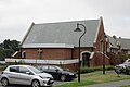
Buxted Methodist Church
(More images) |
 |
Buxted
50.9905°N 0.1356°E / 50.9905; 0.1356 (Buxted Methodist Church, Buxted) |
Methodist |
– |
In 1907, the local Wesleyan Methodist community built a chapel on Buxted High Street. A coach-house on adjacent land had previously served as a place of worship; it survived until 1988, when the chapel was extended. The name Buxted Methodist Church was adopted in 1932. |
[100][180]
[181] |
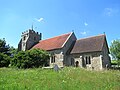
St Bartholomew's Church
(More images) |
 |
Chalvington
50.8636°N 0.1571°E / 50.8636; 0.1571 (St Bartholomew's Church, Chalvington) |
Anglican |
I |
A simple two-cell (nave and chancel) flint and stone church of the 13th century serves the hamlet of Chalvington. One window may have the oldest stained glass in Sussex, and the east window (inserted in 1400) has stained glass from about that date. A small belfry on the roof has a broach spire supported on a weatherboarded turret. |
[182][32]
[183][184] |
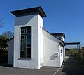
Chelwood Gate Church
(More images) |
 |
Chelwood Gate
51.0490°N 0.0234°E / 51.0490; 0.0234 (Chelwood Gate Church, Chelwood Gate) |
Anglican |
– |
This small church is part of the parish of All Saints Church, Danehill. It is next to the village hall in the hamlet of Chelwood Gate. |
[185][186] |
Chiddingly Church
(More images) |
 |
Chiddingly
50.9062°N 0.1956°E / 50.9062; 0.1956 (Chiddingly Church, Chiddingly) |
Anglican |
I |
The Perpendicular Gothic Revival tower bears the oldest of three stone spires in Sussex. The church dates from the mid-13th century, although the chancel is a Victorian rebuild of 1864. The aisled nave has old memorial tablets set into the floor. A private memorial chapel occupies the south transept. |
[184][187]
[33][188]
[189] |
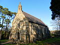
Holy Trinity Church
(More images) |
 |
Colemans Hatch
51.0855°N 0.0692°E / 51.0855; 0.0692 (Holy Trinity Church, Coleman's Hatch) |
Anglican |
II |
Arthur Blomfield's Gothic Revival church, of local sandstone, has an apse, a tall tower with a steeple and some exterior half-timbering. The tracery in the lancet windows is reminiscent of the Decorated Gothic style. The building was finished in 1913. |
[190][69]
[191][192] |
St Bartholomew's Church
(More images) |
 |
Cross-in-Hand
50.9716°N 0.2339°E / 50.9716; 0.2339 (St Bartholomew's Church, Cross-in-Hand) |
Anglican |
– |
The parish church at Waldron was closed for restoration in 1862, so worshippers gathered at Cross-in-Hand instead, and a resident offered land at Peat Wood for a chapel of ease to be built. J.P. St Aubyn's Decorated Gothic local stone building seated 200 people and was consecrated on 24 August 1863. A transept and vestry were added in 1901. |
[168][87]
[193][194] |
Cross-in-Hand Methodist Church
(More images) |
 |
Cross-in-Hand
50.9730°N 0.2182°E / 50.9730; 0.2182 (Cross-in-Hand Methodist Church, Cross-in-Hand) |
Methodist |
– |
Glovers Chapel—a barn attached to a farmhouse—was replaced by this purpose-built chapel for the Methodist community in 1895. Trayton Durrant's red-brick Early English-style building had stabling for the horses of itinerant preachers. The 150-capacity church opened on 24 January 1896 and was registered for marriages five years later. It is now in the Eastbourne Circuit. |
[168][87]
[195][196]
[197][198] |
Holy Cross Chapel
(More images) |
 |
Cross-in-Hand
50.9717°N 0.2006°E / 50.9717; 0.2006 (Holy Cross Chapel, Cross-in-Hand) |
Roman Catholic |
– |
In 2014, this chapel within the grounds of the Holy Cross Convent opened for public worship as a Mass centre in the Catholic parish of Burwash. It replaced St Catherine's Church in Heathfield, built in 1953. The convent is occupied by an order of Benedictine sisters. The chapel was registered for marriages in August 2015. |
[199][200]
[201][202] |
All Saints Church
(More images) |
 |
Crowborough
51.0554°N 0.1649°E / 51.0554; 0.1649 (All Saints Church, Crowborough) |
Anglican |
II |
Sir Henry Fermor paid for a church "for the use and benefit of the very ignorant and heathenish people" of Crowborough. The 1744 church was rebuilt in Neo-Norman style (with some Classical and Italianate elements) by Richard Whitfield and John Thomas at the request of Lord Abergavenny. |
[87][203]
[204][205]
[51][206]
[207] |
Poundfield Hall
(More images) |
 |
Crowborough
51.0558°N 0.1797°E / 51.0558; 0.1797 (Poundfield Hall, Crowborough) |
Churches of God |
– |
Originally the Poundfield Meeting Room, this long-established Nonconformist place of worship was rebuilt in 2005 and now serves as a multipurpose community hall and Churches of God (Needed Truth Brethren) meeting place. The older building was registered for worship and for marriages in May 1952. |
[208][209]
[210][211] |
Crowborough Community Church
(More images) |
 |
Crowborough
51.0606°N 0.1604°E / 51.0606; 0.1604 (Christ Church, Crowborough) |
Evangelical |
– |
Originally an Episcopal Free Church of England place of worship called Christ Church, this was funded by local benefactor Elizabeth de Lannoy in 1879. Building work finished in 1883, two years after the church was registered for marriages. A rectory, lecture room and school building were built later. The Perpendicular Gothic Revival church has dormer windows in the roof, and is mainly of brick with some stonework. It is now occupied by a Newfrontiers-aligned charismatic Evangelical congregation. |
[212][54]
[213][214]
[215] |
St Mary Mother of Christ's Church
(More images) |
 |
Crowborough
51.0540°N 0.1659°E / 51.0540; 0.1659 (St Mary Mother of Christ's Church, Crowborough) |
Roman Catholic |
– |
A church was built for Crowborough's Roman Catholic population in 1911 and was registered for marriages in March 1914. The brick and stone building, with a partly timbered tower supporting a small spire, faces All Saints Church across a green. Additions in 1922 included an attached presbytery, and the church was parished in that year. |
[87][216]
[217][86]
[218][219]
[220] |
Crowborough United Church
(More images) |
 |
Crowborough
51.0531°N 0.1614°E / 51.0531; 0.1614 (Crowborough United Church, Crowborough) |
United Reformed Church/Methodist |
– |
This cost £2,000 to build in 1907: it was expensively endowed in memory of theologian Joseph Parker, and was originally called the Parker Memorial Congregational Church. The Queen Anne-style red-brick building, by Edward Knight, also has some external timberwork. Methodists joined the congregation after their church on Croft Road was closed. The chapel was registered for marriages in September 1907. |
[87][221]
[208][222]
[223][224] |
All Saints Church
(More images) |
 |
Danehill
51.0297°N 0.0017°W / 51.0297; -0.0017 (All Saints Church, Danehill) |
Anglican |
II |
George Frederick Bodley and Thomas Garner's Decorated Gothic stone church occupies a prominent, high position at the village crossroads. The large church, built in 1892 to replace a smaller brick and stone building of 1836 (by architect John Cowper) was parished in 1898: it took over parts of Fletching and Horsted Keynes parishes. |
[54][225]
[226][227]
[228] |
Forest Hall
(More images) |
 |
Dodd's Bank, Nutley
51.0221°N 0.0658°E / 51.0221; 0.0658 (Forest Hall, Dodd's Bank, Nutley) |
Open Brethren |
– |
Locally nicknamed "The Chapel in the Woods" and located in the parish of Maresfield near Nutley village, this Brethren gospel hall was established in 1897 and was licensed for certifying marriages ten years later. |
[229][230]
[231][232]
[233] |
St Simon and St Jude's Church
(More images) |
 |
East Dean
50.7580°N 0.2066°E / 50.7580; 0.2066 (St Simon and St Jude's Church, East Dean) |
Anglican |
I |
The chancel, nave and thick-walled three-stage tower are mostly Norman with some Saxon material, although the church was extended in 1885 and 1961. The base of the tower formed part of the original nave: a rare arrangement. A porch was added in the 15th century, as was a king post roof, and the Jacobean pulpit dates from 1623. The churchyard has a Tapsel gate. |
[234][235]
[12][236] |
East Hoathly Church
(More images) |
 |
East Hoathly
50.9249°N 0.1616°E / 50.9249; 0.1616 (East Hoathly Church, East Hoathly) |
Anglican |
II* |
The castellated tower and its stair-turret are 15th-century Perpendicular Gothic, but the rest of the church was rebuilt in 1856 in Early English style. The nave has aisles on both sides. The small piscina may survive from a Norman church on the site. |
[237][238]
[26][59]
[239] |
Holy Trinity Church
(More images) |
 |
Eridge Green
51.0989°N 0.2232°E / 51.0989; 0.2232 (Holy Trinity Church, Eridge Green) |
Anglican |
II |
Nikolaus Pevsner compared this long, low church to a school building. Its central entrance has a belfry above and leads directly into the nave. The Perpendicular Gothic Revival building, funded by the Earl of Abergavenny, is stone-built and dates from 1852. A later Marquess funded restoration in 1950. |
[238][59]
[240][241] |
Christ Church
(More images) |
 |
Fairwarp
51.0217°N 0.0888°E / 51.0217; 0.0888 (Christ Church, Fairwarp) |
Anglican |
II |
The Eckstein baronets paid for a significant enlargement of this church in 1930: the main addition was a tower with a curious two-stage staircase and lancet windows. The Early English-style local stone building was designed in 1881 by Major Rohde Hawkins and has a windowless apse at the east end. |
[242][243]
[67] |
Five Ash Down Independent Chapel
(More images) |
 |
Five Ash Down
50.9937°N 0.1033°E / 50.9937; 0.1033 (Five Ash Down Independent Chapel, Five Ash Down) |
Evangelical |
– |
Inspired by a "fiery sermon" preached in Uckfield, Thomas Dicker founded an Independent chapel on his father's land in 1784. The church which became Uckfield Baptist Church seceded the following year after doctrinal disagreements. The Early English-style building was given a new three-bay blue-brick façade (with contrasting quoins) in the 1870s. There is a graveyard in front of the building. A marriage licence was granted in September 1895. The congregation is now an Evangelical fellowship, independent of denominational links and based on Reformed ecclesiology. |
[244][245]
[246][247]
[248][249]
[250][251] |
St Andrew's and St Mary the Virgin Church
(More images) |
 |
Fletching
50.9929°N 0.0349°E / 50.9929; 0.0349 (St Andrew & St Mary the Virgin Church, Fletching) |
Anglican |
I |
Fletching's parish church is of three eras: Norman architecture is represented by the tower, the body of the church (including its transepts) is 13th-century, and John Oldrid Scott carried out restoration—principally of the chancel—in 1880. Norman evidence can also be seen in the nave, where two unevenly placed windows are of that era. John Baker-Holroyd, 1st Earl of Sheffield built a mausoleum in the north transept; his friend Edward Gibbon is also buried in it. |
[252][35]
[34][253] |
St Peter's Church
(More images) |
 |
Folkington
50.8128°N 0.2121°E / 50.8128; 0.2121 (St Peter's Church, Folkington) |
Anglican |
I |
This two-cell flint and stone church, without an arch between the chancel and nave, also has a timber-framed roof and a belfry with weatherboarded sides. The lancet windows are Perpendicular Gothic in style. Old box-pews survive inside, and Viscount Monckton has a memorial stone. |
[253][254]
[255][36]
[256] |
Holy Trinity Church
(More images) |
 |
Forest Row
51.0981°N 0.0330°E / 51.0981; 0.0330 (Holy Trinity Church, Forest Row) |
Anglican |
II |
William Moseley's church is an Early English Gothic Revival building of stone and ashlar, with a narrow tower and a small spire. Herbert Green's extensions of 1877–78 included an aisle on the south side of the nave. The barn-like wooden roof is intricate. |
[257][258]
[53] |
Forest Row Baptist Church
(More images) |
 |
Forest Row
51.0952°N 0.0408°E / 51.0952; 0.0408 (Forest Row Baptist Church, Forest Row) |
Baptist |
– |
The present chapel, with a roughcast exterior and Gothic appearance, was built in 1841, but a building for Baptists is believed to have existed in Forest Row as early as 1811. The windows are lancets. It was registered for marriages with the name Bethesda Chapel in June 1844. |
[53][259]
[260] |
Christian Community Church
(More images) |
 |
Forest Row
51.0954°N 0.0383°E / 51.0954; 0.0383 (Christian Community Church, Forest Row) |
The Christian Community |
– |
This is part of a now worldwide Movement for Religious Renewal, founded in Switzerland in 1922. The present church in Forest Row was opened on 12 September 1993, succeeding (and retaining the registration of) rooms in a building in nearby Ashurst Wood which were registered for worship in December 1964. |
[261][262] |
St Thomas a Becket's Church
(More images) |
 |
Framfield
50.9626°N 0.1276°E / 50.9626; 0.1276 (St Thomas a Becket's Church, Framfield) |
Anglican |
II |
The approach to this 13th-century church runs between well-preserved timber-framed medieval cottages. A fire in 1509 led to the church being rebuilt and extended, and the tower was remodelled in 1892 by B.E. Ferrey. A 1960s stained-glass window depicts children at play. |
[253][263]
[264][37]
[265][266] |
St Alban's Church
(More images) |
 |
Frant
51.0982°N 0.2699°E / 51.0982; 0.2699 (St Alban's Church, Frant) |
Anglican |
II |
Local architect John Montier designed a Perpendicular Gothic Revival church for Frant village in 1819. Work continued until 1822, and the chancel was extended in 1868. The 20th-century lychgate is hexagonal—an unusual design. Iron columns support a wooden gallery. The prominent tower is castellated. Some 15th-century stained glass has been inserted. |
[53][267]
[268][269]
[270] |
St Mary the Virgin Church
(More images) |
 |
Friston
50.7625°N 0.1989°E / 50.7625; 0.1989 (St Mary the Virgin Church, Friston) |
Anglican |
I |
Composer Frank Bridge is commemorated at this small, two-cell church, to which a single transept was added in 1892. The porch and king post roof are 15th-century; the chancel was renovated a century earlier. A Tapsel gate leads to the churchyard. Traces of Saxon material remain throughout. |
[270][271]
[272][13] |
Gamelands Methodist Church
(More images) |
 |
Gamelands, Horam
50.9167°N 0.2420°E / 50.9167; 0.2420 (Gamelands Methodist Church, Gamelands) |
Methodist |
– |
This red-brick chapel is on the road leading south from Horam. It was founded in 1900 by George Wheen, who had held services in his house for several years before that. The chapel, which is in the Eastbourne Methodist Circuit, was registered for marriages in June 1949. |
[195][53]
[273][274] |
Golden Cross Chapel
(More images) |
 |
Golden Cross
50.8913°N 0.1861°E / 50.8913; 0.1861 (Golden Cross Chapel, Golden Cross) |
Strict Baptist |
– |
Founded as Dunk's Chapel, this Vernacular red-brick chapel was built in 1813 to replace a nearby barn which had been used for Baptist meetings. It later became Little Dicker Chapel, but in 2004 the pastor had to change its name because "depraved" jokers repeatedly vandalised the nameboard to spell sexually suggestive words. |
[169][275]
[276][277]
[278][279]
[280] |
St Thomas the Apostle's Church
(More images) |
 |
Groombridge
51.1107°N 0.1861°E / 51.1107; 0.1861 (St Thomas the Apostle's Church, Groombridge) |
Anglican |
II |
New Groombridge—the Sussex part of this Kent-border village—is served by Norman Shaw's Perpendicular Gothic Revival church of local sandstone. Charles Eamer Kempe designed the stained glass, and H.S. Goodhart-Rendel was responsible for some internal fittings. The roof has a tiled belfry. |
[281][282]
[101] |
Church of St Pius V
(More images) |
 |
Groombridge
51.1149°N 0.1854°E / 51.1149; 0.1854 (Church of St Pius V, Groombridge) |
Society of Saint Pius X |
– |
Built as a Wesleyan Methodist chapel in 1857, this Classical-influenced building was sold to the Traditionalist Catholic Society of Saint Pius X after it closed in about 1983 (although its marriage registration as a Methodist chapel, granted in February 1906, was not formally cancelled until August 1992). The windows and doorway in the three-bay façade are round-headed, and there are stuccoed quoins and a pediment. The chapel is mostly red-brick. |
[101][283]
[284][285] |
St Mark's Church
(More images) |
 |
Hadlow Down
50.9967°N 0.1787°E / 50.9967; 0.1787 (St Mark's Church, Hadlow Down) |
Anglican |
II |
William Moseley designed this parish church in 1836, but its present Perpendicular Gothic Revival appearance is attributable to George Fellowes Prynne's alterations of 1913. The tower rises straight from the west porch and is topped by a narrow spire. The nave has a Lady chapel with a version of the Madonna of the Magnificat. |
[101][286]
[287] |
St Mary the Virgin Church
(More images) |
 |
Hailsham
50.8631°N 0.2603°E / 50.8631; 0.2603 (St Mary the Virgin Church, Hailsham) |
Anglican |
I |
A medieval appearance is belied by major rebuilding in 1870 and 1889, when the church was given its consistent Perpendicular Gothic style. The buttressed tower is built of alternating flint and stone blocks. Inside, a 13th-century capital was probably moved here from nearby Michelham Priory. |
[288][289]
[290] |
Hailsham Gospel Mission
(More images) |
 |
Hailsham
50.8610°N 0.2577°E / 50.8610; 0.2577 (Hailsham Gospel Mission, Hailsham) |
Countess of Huntingdon's Connexion |
– |
The Countess of Huntingdon's Connexion owns this place of worship on Hailsham's Station Road. Regular Sunday services are held. It was registered for worship in May 1982 and for the solemnisation of marriages in March 1984. |
[291][292]
[293]
[294] |
ChristChurch
(More images) |
 |
Hailsham
50.8597°N 0.2508°E / 50.8597; 0.2508 (ChristChurch, Hailsham) |
Evangelical |
– |
ChristChurch is an Evangelical church associated with the Newfrontiers movement. Although it has occupied its church building on the Ropemaker Park industrial estate only since 2014, the community was founded in 1981 and previously worshipped in other venues. |
[295][296] |
Hailsham Free Church
(More images) |
 |
Hailsham
50.8617°N 0.2561°E / 50.8617; 0.2561 (Hailsham Free Church, Hailsham) |
Evangelical |
– |
This church was recorded as Congregational when it was registered for marriages in June 1909, but it now belongs to the Fellowship of Independent Evangelical Churches. It was built in a prominent position at the junction of Western Road and South Street in 1905, with space for a hall underneath. The free-style Renaissance building is of red brick with some stonework. |
[101][297]
[105] |
Kingdom Hall
(More images) |
 |
Hailsham
50.8611°N 0.2588°E / 50.8611; 0.2588 (Kingdom Hall, Hailsham) |
Jehovah's Witnesses |
– |
This replaced an earlier Kingdom Hall on the town's Falcon Way, which closed in 1994. Its proposed demolition and replacement by flats in 2004 caused controversy and did not go ahead. The new building was registered for marriages in April 1996, and is used by the Hailsham Congregation of Jehovah's Witnesses. |
[298][299]
[300][301] |
Hailsham Methodist Church
(More images) |
 |
Hailsham
50.8653°N 0.2570°E / 50.8653; 0.2570 (Hailsham Methodist Church, Hailsham) |
Methodist |
– |
A late-20th-century porch is the main addition to the stuccoed Neoclassical chapel at the top of Hailsham High Street. There are three round-arched windows on the façade, each in a recess. The building dates from 1868 and was built for Wesleyan Methodists; it was registered for marriages in January 1885. It is now part of Eastbourne Methodist Circuit. |
[195][101]
[302][303] |
Gordon Road Evangelical Church
(More images) |
 |
Hailsham
50.8593°N 0.2544°E / 50.8593; 0.2544 (Gordon Road Evangelical Church, Hailsham) |
Open Brethren |
– |
This assembly of Open Brethren meet in a building previously known as Gordon Gospel Hall, under which name it was registered for marriages in June 1945. |
[233][304]
[305][306] |
St Wilfrid's Church
(More images) |
 |
Hailsham
50.8605°N 0.2557°E / 50.8605; 0.2557 (St Wilfrid's Church, Hailsham) |
Roman Catholic |
– |
The present church, which opened on 31 October 2015, is the third on the site, although the other two buildings survive as well. Prolific local architect Henry Bingham Towner's first church—a "pleasant little" yellow-brick building with statues by Joseph Cribb and a shingled roof—opened in 1955, and additions were made in 1957 and 1966 (the high-quality oak porch dates from the latter year). It replaced an earlier building of 1922 on the same site, which survives as a meeting room. The 1955 building is now the church hall. The church's marriage registration dates from March 1953. |
[101][307]
[308][80]
[309] |
Corinthian Church
(More images) |
 |
Hailsham
50.8654°N 0.2556°E / 50.8654; 0.2556 (Corinthian Church, Hailsham) |
Spiritualist |
– |
This Spiritualist church and healing centre was founded in a building called Primrose Hall in Hailsham in 1993. Under that name it was registered for marriages in November 2000. |
[310][311]
[312] |
Hailsham Baptist Church
(More images) |
 |
Hailsham
50.8608°N 0.2615°E / 50.8608; 0.2615 (Hailsham Baptist Church, Hailsham) |
Strict Baptist |
– |
Hailsham's Strict Baptist community, established in 1792, worshipped in a wooden building from 1795 until a permanent brick and stone structure was built in the 1820s or 1830s. It was registered for marriages in March 1838. The present chapel is a 1909 rebuilding of the latter; the original wooden galleries and pulpit were retained though. |
[244][101]
[313][314]
[315][316] |
Halland Chapel
(More images) |
 |
Halland
50.9300°N 0.1373°E / 50.9300; 0.1373 (Halland Chapel, Halland) |
Baptist |
– |
A local man called Mr Matthews founded and built this red-brick chapel (originally called Halland Independent Chapel) in 1892. The Baptist congregation had formed in 1882; they met in a cottage at first. With the name Calvinistic Independent Chapel it was registered for marriages in August 1901. |
[244][101]
[317][318]
[319] |
St Stephen's Church
(More images) |
 |
Hammerwood
51.1368°N 0.0559°E / 51.1368; 0.0559 (St Stephen's Church, Hammerwood) |
Anglican |
II* |
Architect E.P. Loftus Brock was responsible for this church near Hartfield, which was funded by banker Oswald Smith. It was parished from its opening in 1880: territory came from East Grinstead and Hartfield parishes. Standing on a "fine site", the stone Early English-style church has a buttressed tower with a spire and Clayton and Bell stained glass. In November 2016 it was upgraded to Grade II* listed status. |
[101][320]
[65][321] |
St Mary the Virgin Church
(More images) |
 |
Hartfield
51.1017°N 0.1120°E / 51.1017; 0.1120 (St Mary the Virgin Church, Hartfield) |
Anglican |
I |
The north wall is the oldest part of this church: it has Norman masonry and a 13th-century trefoil-headed lancet window, now blocked. An arcaded aisle was added to the 13th-century nave a century later; the buttressed tower, with a broach spire, is 15th-century. There is no chancel arch: it may have been removed during 16th-century rebuilding. The lychgate is built into a medieval cottage—a very rare form. |
[322][323]
[27][324] |
Emmanuel Church
(More images) |
 |
Hawkswood, Hailsham
50.8762°N 0.2608°E / 50.8762; 0.2608 (Emmanuel Church, Hawkswood) |
Anglican |
– |
The parish of this modern Anglican church, carved out of Hailsham parish in 2005, covers the northern suburbs of Hailsham and the hamlet of Magham Down. |
[325][326] |
St Richard's Church
(More images) |
 |
Heathfield
50.9667°N 0.2573°E / 50.9667; 0.2573 (St Richard's Church, Heathfield) |
Anglican |
– |
Granville Streatfeild designed this town-centre church in 1915. It is of red brick with lancet windows, the largest of which are Perpendicular Gothic in style. The building has a chancel, nave with aisles on each side and a thin chimney. Most building materials are local. Extensions were made in 1963. |
[70][168]
[327] |
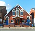
Welcome Evangelical Baptist Church
(More images) |
 |
Heathfield
50.9650°N 0.2576°E / 50.9650; 0.2576 (Welcome Baptist Church, Heathfield) |
Baptist |
– |
Opened in 1886 as the Gilbert Memorial Chapel (commemorating the "Sussex Apostle" George Gilbert, who founded about 40 Baptist churches in East Sussex), this Independent Baptist chapel was given a new red-brick Renaissance-style façade in the 20th century. The original walls can still be seen behind this. With the name Welcome Mission Hall it was registered for marriages in August 1909. |
[168][244]
[327][328]
[329][330]
[331] |
Union Church
(More images) |
 |
Heathfield
50.9712°N 0.2505°E / 50.9712; 0.2505 (Union Church, Heathfield) |
Baptist/
Congregational Federation |
– |
Edward Knight's church, on a prominent corner site at the top of the High Street, dates from 1899–1900 and is an Early English Gothic Revival-style building of red brick with stone dressings. It was registered for marriages in July 1904. |
[168][328]
[132][327]
[332][333] |
King's Church
(More images) |
 |
Heathfield
50.9707°N 0.2510°E / 50.9707; 0.2510 (King's Church, Heathfield) |
Evangelical |
– |
This Evangelical church, based at the State Hall in the centre of Heathfield, is aligned with the Evangelical Alliance and the Newfrontiers movement. It has its origins in the 1980s, but the current premises were registered for worship in January 1998 and for marriages in June 2005. |
[168][334]
[335][336] |
St Peter and St Paul's Church
(More images) |
 |
Hellingly
50.8886°N 0.2462°E / 50.8886; 0.2462 (St Peter and St Paul's Church, Hellingly) |
Anglican |
I |
The oldest parts are 12th-century, but the church stands on a pre-Christian burial mound. The tower has a Georgian appearance but is later than that era: it was rebuilt in 1836. A brass monument of a woman in a head-dress dates from the 1440s; it was found during Victorian restoration work. |
[337][338]
[17][339]
[340][341] |
St John the Evangelist's Church
(More images) |
 |
Heron's Ghyll
51.0231°N 0.1115°E / 51.0231; 0.1115 (St John's Church, Heron's Ghyll) |
Roman Catholic |
II |
This remote church, an ashlar Gothic Revival building of 1896–97 by Frederick Walters, is heavily buttressed and has a central tower above the nave and chancel. The 14th Duchess of Norfolk lived at nearby Heron's Ghyll House, where Mass had been celebrated from 1866 (when Coventry Patmore owned it); her grandson paid for the church to be built. It was registered for marriages in November 1897. |
[342][343]
[64][84]
[344][345] |
All Saints Church
(More images) |
 |
Herstmonceux
50.8678°N 0.3331°E / 50.8678; 0.3331 (All Saints Church, Herstmonceux) |
Anglican |
I |
The church stands near the castle but distant from the village. The tower and one wall are 12th-century, but an older church stood on the site. Monuments to the 8th and 9th Barons Dacre and Sir William Fiennes demonstrate a long connection with the aristocracy. |
[340][346]
[347][348] |
Herstmonceux Free Church
(More images) |
 |
Herstmonceux
50.8855°N 0.3279°E / 50.8855; 0.3279 (Herstmonceux Free Church, Herstmonceux) |
Congregational Federation |
II |
Built as a Congregational chapel in 1811, this "pretty" (to Pevsner) Classical-style building stands at Chapel Cross, 1.4 miles (2.3 km) from Herstmonceux. It has grey and red brickwork, now painted over round-headed windows and an open pediment above a porch. Mid 19th-century additions included a Sunday school and wooden galleries. Following the passing of the Marriage Act 1836, which came into effect on 1 January 1837, it was registered for the solemnisation of marriages that September. |
[104][64]
[349][350]
[351][352]
[353] |
Herstmonceux Friends Meeting House
(More images) |
 |
Herstmonceux
50.8905°N 0.3200°E / 50.8905; 0.3200 (Herstmonceux Friends Meeting House, Herstmonceux) |
Quaker |
– |
Quaker meetings have been held in the village since 1713. Although the present building has a 19th-century appearance as a result of an extension and remodelling in 1898–99, its origins lie in a low rectangular chapel of 1734 which survives behind the gabled two-storey cottage-style brick façade. Inside, there is a 1734 date-stone above a blocked door. The attached burial ground was closed to new burials in 1897. |
[64][350]
[354][355] |
Holy Trinity Church
(More images) |
 |
High Hurstwood
51.0184°N 0.1298°E / 51.0184; 0.1298 (Holy Trinity Church, High Hurstwood) |
Anglican |
II |
Politician Francis Venables-Vernon-Harcourt's wife Lady Catherine paid for this remote church near her home at Buxted (Pevsner said its flower-ringed valley setting was "Arcadia indeed"). An unknown architect designed it in 1870–72, and a half-timbered tower was added in 1903. Some of the lancet windows have tracery. |
[64][356]
[357] |
St Oswald's Church
(More images) |
 |
Hooe
50.8576°N 0.3895°E / 50.8576; 0.3895 (St Oswald's Church, Hooe) |
Anglican |
I |
Standing apart from its village—perhaps because the centre of population was forced away by the Black Death—this Perpendicular sandstone church was restored in the 15th century but retains 12th-century work in the chancel and its side chapel. The east window has ancient stained glass depicting the Coronation of the Virgin. |
[358][359]
[40][360]
[361] |
Christ Church
(More images) |
 |
Horam
50.9316°N 0.2446°E / 50.9316; 0.2446 (Christ Church, Horam) |
Anglican |
– |
Percy Monkton's small church of 1890 was to have been replaced by an expansive new building less than 25 years later—but these plans were never followed through, and the red-brick Gothic-style building remains. It has a belfry and lancet windows, and there is evidence of later extensions. |
[64][362] |
Horam Chapel
(More images) |
 |
Horam
50.9353°N 0.2443°E / 50.9353; 0.2443 (Horam Chapel, Horam) |
Evangelical |
– |
This modern building stands in the centre of Horam village. It was registered for worship and for marriages in February 1996 in place of the former Gospel Hall in Maynard's Green, which had closed. |
[363][364]
[365] |
St Margaret's Church
(More images) |
 |
Isfield
50.9445°N 0.0539°E / 50.9445; 0.0539 (St Margaret's Church, Isfield) |
Anglican |
I |
Many members of the Shurley family, including John Shurley (d. 1527), are buried in their own chapel which forms a transept at this church. One 13th-century lancet window survives in the nave, and some other features are Decorated Gothic. Work in 1893 included the addition of a belfry and spire to the mostly Norman tower. A good example of a hagioscope survives in the chancel. |
[366][367]
[19][368]
[369] |
St Michael and All Angels Church
(More images) |
 |
Jarvis Brook
51.0463°N 0.1904°E / 51.0463; 0.1904 (St Michael and All Angels Church, Jarvis Brook) |
Anglican |
– |
A school built in 1880 was used for worship until J.B. Tansley's stone and timbered chapel of ease to Crowborough parish church was completed in 1906 at a cost of £2,000. William Nevill, 1st Marquess of Abergavenny donated the land. The nave has lancet windows and no aisles, and there is a bellcote. |
[68][370]
[371] |
St Richard's Church
(More images) |
 |
Jarvis Brook
51.0418°N 0.1713°E / 51.0418; 0.1713 (St Richard's Church, Jarvis Brook) |
Anglican |
– |
Another church associated with All Saints in Crowborough, this brick building (originally called St Richard's Hall) was finished in 1957 and serves the Alderbrook area near Jarvis Brook. Extensions have been built since the church opened. |
[73]
[371][372] |
Rehoboth Chapel
(More images) |
 |
Jarvis Brook
51.0417°N 0.1806°E / 51.0417; 0.1806 (Rehoboth Chapel, Jarvis Brook) |
Strict Baptist |
– |
This red- and blue-brick building dates from 1876. Its Gospel Standard Strict Baptist congregation, maintains links with the Forest Fold chapel on the other side of Crowborough. Seceders from that chapel founded the Jarvis Brook cause in 1852; they met in a schoolroom at first. The chapel was registered for the solemnisation of marriages in November 1893. |
[137][68]
[373][374]
[375][376]
[377] |
Kingdom Hall
(More images) |
 |
Jarvis Brook
51.0484°N 0.1864°E / 51.0484; 0.1864 (Kingdom Hall, Jarvis Brook) |
Jehovah's Witnesses |
– |
The Crowborough Congregation of Jehovah's Witnesses registered a hall off Crowborough Hill in July 1967. It was replaced by the present Kingdom Hall in March 1992. |
[208][378]
[379][378]
[380][381] |
Jarvis Brook Memorial Hall
(More images) |
 |
Jarvis Brook
51.0484°N 0.1868°E / 51.0484; 0.1868 (Jarvis Brook Memorial Hall, Jarvis Brook) |
Spiritualist |
– |
This hall has been used as a Nonconformist place of worship for many years. Its present congregation is affiliated with the United Spiritualists movement. |
[208][382] |
St Andrew's Church
(More images) |
 |
Jevington
50.7921°N 0.2140°E / 50.7921; 0.2140 (St Andrew's Church, Jevington) |
Anglican |
I |
The substantial tower of this ancient village's church is 10th-century, and other Saxon evidence is visible in two blocked windows, which reused Roman material. St Lewinna, a 7th-century martyr, was allegedly buried here; her remains were apparently stolen in 1058. The rest of the church is 13th-century and in the Early English style. A porch was built in 1873. |
[383][384]
[14][385] |
All Saints Church
(More images) |
 |
Laughton
50.8931°N 0.1325°E / 50.8931; 0.1325 (All Saints Church, Laughton) |
Anglican |
I |
Mostly Perpendicular Gothic, with a 13th-century nave and a castellated tower, this church is most famous for its association with the Pelham baronetcy. Many family members are buried here, including two prime ministers: Henry Pelham and the 1st Duke of Newcastle. The chancel is 18th-century, and the porch is Victorian. |
[386][387]
[41][388] |
St Michael the Archangel's Church
(More images) |
 |
Litlington
50.7971°N 0.1603°E / 50.7971; 0.1603 (St Michael the Archangel's Church, Litlington) |
Anglican |
I |
A simple building with nave, chancel and spire-topped weatherboarded bell-tower, Litlington's church is mostly 12th-century. Other ancient features include three sundials, a 13th-century piscina and sedile, an Easter sepulchre, a 15th-century bell and one very old stained-glass window. Restoration in 1863 added a multicoloured tiled floor. |
[389][390]
[20][391] |
St Michael and All Angels Church
(More images) |
 |
Little Horsted
50.9453°N 0.0919°E / 50.9453; 0.0919 (St Michael and All Angels Church, Little Horsted) |
Anglican |
II |
This hamlet near Uckfield is also called Horsted Parva. Its church, with a prominent ashlar Perpendicular Gothic Revival tower, was expensively restored in the Early English style by George Gilbert Scott in 1863. An arcade of four blocked windows (called "a remarkable motif" by Pevsner) in the chancel wall may be Saxon. |
[392][393]
[21][394]
[395] |
Zoar Strict Baptist Chapel
(More images) |
 |
Lower Dicker
50.8790°N 0.2270°E / 50.8790; 0.2270 (Zoar Strict Baptist Chapel, Lower Dicker) |
Strict Baptist |
– |
Originally called The Dicker Chapel, this 400-capacity building dates from 1837 and was registered for marriages seven years later. On a main road in a remote spot, it serves a wide area and had extensive stables for worshippers arriving on horseback. The Classical-style stuccoed brick chapel, enlarged and refronted in 1874, has a pediment, porch and pilasters. |
[169][350]
[137][57]
[396][397]
[398][399] |
St Wilfrid's Church
(More images) |
 |
Lower Willingdon
50.8107°N 0.2411°E / 50.8107; 0.2411 (St Wilfrid's Church, Lower Willingdon) |
Anglican |
– |
This Eastbourne suburb is served by this church within the parish of Polegate's St John's Church (but independent from it since 2002). It was established in 1962. Worship is in the Conservative Evangelical tradition of the Church of England, and the church belongs to the Fellowship of Confessing Anglicans and the Evangelical Alliance. |
[400][401]
[74][402] |
Trinity Church
(More images) |
 |
Lower Willingdon
50.8081°N 0.2470°E / 50.8081; 0.2470 (Trinity Church, Lower Willingdon) |
Baptist/Methodist/
United Reformed Church |
– |
Now used by three denominations, this red-brick church was built in 1894 for Methodists. Like many churches in the Eastbourne area, it suffered bomb damage in World War II and closed for several years for reconstruction. The windows are lancets, and there is exterior stonework. It was registered for marriages with the name Willingdon United Free Church in July 1939. |
[195][403]
[404][405] |
Life Christian Centre
(More images) |
 |
Lower Willingdon
50.8120°N 0.2460°E / 50.8120; 0.2460 (Downs Valley Apostolic Church, Lower Willingdon) |
Pentecostal |
– |
This church, previously known as Downs Valley Apostolic Church, serves the Pentecostal and Apostolic communities in the Eastbourne area, and offers two services on Sundays. It was originally built as an Evangelical church, but by 1981 the building was vacant. That spring the owner gave it to the Apostolic Church, and it was reopened as Downs Valley Apostolic Church on 5 April 1981. |
[400][406]
[407] |
Church of the Good Shepherd
(More images) |
 |
Lullington
50.8069°N 0.1676°E / 50.8069; 0.1676 (Church of the Good Shepherd, Lullington) |
Anglican |
I |
"Not easily forgotten", according to Nikolaus Pevsner, this tiny building—merely part of the chancel of the original church—is often called the smallest church in England: it is 256 sq ft (24 m2) and holds 20 people. The old foundations survive near the entrance. What remains is Early English in style, dating from the 13th/14th century. A wooden belfry was added in 1806. |
[408][409]
[38][410] |
St Bartholomew's Church
(More images) |
 |
Maresfield
50.9969°N 0.0875°E / 50.9969; 0.0875 (St Bartholomew's Church, Maresfield) |
Anglican |
I |
The large Perpendicular-style tower is 15th-century, and Norman work is visible in a window and around the north door, but John Oldrid Scott's restoration of 1875–79 gave Maresfield's church its present appearance. He realigned the interior: the original chancel arch now leads to the north transept, and the east window now faces south. Interior fittings include an 18th-century pulpit. |
[411][412]
[28] |
St Mark's Church
(More images) |
 |
Mark Cross
51.0590°N 0.2571°E / 51.0590; 0.2571 (St Mark's Church, Mark Cross) |
Anglican |
– |
E.E. Cronk converted this former school (built in 1851) into a church in 1873. It was within the parish of Rotherfield until 1874, when it was given its own parish from parts of Wadhurst and Rotherfield. A very large east window was the main structural alteration to the stone and brick building. |
[279][62] |
St Dunstan's Church
(More images) |
 |
Mayfield
51.0207°N 0.2606°E / 51.0207; 0.2606 (St Dunstan's Church, Mayfield) |
Anglican |
I |
Dunstan himself built a wooden church on the site in the 10th century. Its stone replacement burnt down in 1389 and was rebuilt in the Perpendicular style, although the stubby tower and its spire retain their 13th-century appearance. The church has a wooden chancel arch ceiling with prominent moulding. |
[413][414]
[49][415]
[416] |
Mayfield Baptist Chapel
(More images) |
 |
Mayfield
51.0196°N 0.2583°E / 51.0196; 0.2583 (Mayfield Baptist Chapel, Mayfield) |
Strict Baptist |
– |
This 250-capacity building has a much smaller congregation than in its 19th-century heyday, but remains in use. It has stood on its village-centre corner site since 1873 (and was registered for marriages two years later), but Baptist worship in the Mayfield area has a much longer history. |
[137][373]
[113][417]
[418][419]
[420][421] |
Colkins Mill Church
(More images) |
 |
Mayfield
51.0201°N 0.2561°E / 51.0201; 0.2561 (Colkins Mill Church, Mayfield) |
Evangelical |
– |
This mid-19th-century Wesleyan Methodist chapel became a Congregational church in 1869. It closed in 1984, by which time it was a United Reformed church; but the lancet-windowed stucco and stone chapel was immediately bought by members of the Evangelical chapel at nearby Colkins Mill, who moved in and renamed it. It was formally registered in June 1992. |
[113][422]
[423][424]
[425] |
St Thomas of Canterbury's Church
(More images) |
 |
Mayfield
51.0198°N 0.2535°E / 51.0198; 0.2535 (St Thomas of Canterbury's Church, Mayfield) |
Roman Catholic |
– |
Henry Bingham Towner, a prolific designer of Roman Catholic churches in Sussex, replaced a 1932 building with this simple Gothic Revival flint and ashlar church in 1957. It is low and long, with a saddleback roof. Two modern stained glass windows have been inserted. The church was registered in October 1957. |
[113][90]
[426][427]
[428][429] |
St Mary the Virgin Church
(More images) |
 |
Ninfield
50.8849°N 0.4226°E / 50.8849; 0.4226 (St Mary the Virgin Church, Ninfield) |
Anglican |
I |
An ancient yew tree survives in the churchyard, but the Saxon church which stood alongside it has gone; the present building has 13th- and 17th-century work, but a major restoration (possibly by Arthur Blomfield) in the 1880s obscures it. The south porch is of brick, unusually, and dates from 1735. The clapboard belfry of 1897 holds a 14th-century bell. |
[430][431]
[46] |
Ninfield Methodist Church
(More images) |
 |
Ninfield
50.8858°N 0.4242°E / 50.8858; 0.4242 (Ninfield Methodist Church, Ninfield) |
Methodist |
– |
The foundation stone of this red-brick chapel in the centre of Ninfield identifies William Booth's wife Catherine as the founder. The building dates from 1871, but was registered under the name Christian Mission Hall between February 1872 and July 1933. |
[102][432]
[433][434] |
St James the Less Church
(More images) |
 |
Nutley
51.0323°N 0.0549°E / 51.0323; 0.0549 (St James the Less Church, Nutley) |
Anglican |
– |
Richard Cromwell Carpenter, who was responsible for many Gothic Revival churches, was commissioned to design Nutley's church in 1845. His steep-roofed stone building was extended in 1871 by the addition of a Decorated Gothic-style north aisle. The west end has a small bellcote. |
[58][435] |
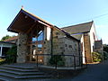
All Saints Church
(More images) |
 |
Old Heathfield
50.9599°N 0.2749°E / 50.9599; 0.2749 (All Saints Church, Old Heathfield) |
Anglican |
II* |
Little has changed at this sandstone church since the 14th century. The tower, with a broach spire, is slightly older and is built of chalk with sandstone on the exterior. Restoration in the 1890s eliminated galleries which had been installed earlier in the century: a large capacity was no longer needed because the vast parish had become smaller as new churches had been built. Former vicar Robert Hunt, a founder of Jamestown, Virginia, is commemorated by a stained-glass window. |
[168][340]
[436][48]
[437] |
St Nicolas' Church
(More images) |
 |
Pevensey
50.8196°N 0.3368°E / 50.8196; 0.3368 (St Nicolas' Church, Pevensey) |
Anglican |
I |
This church has stood next to Pevensey Castle since the 12th century, but the only original material from that time is part of the chancel. The rest was rebuilt in the 13th century and—in the case of the porch and the tower's top stage—the Victorian era (by George Gilbert Scott Jr.). The building is a good example of the Early English Gothic style. |
[438][439]
[30][440] |
St Wilfrid's Church
(More images) |
 |
Pevensey Bay
50.8117°N 0.3507°E / 50.8117; 0.3507 (St Wilfrid's Church, Pevensey Bay) |
Anglican |
– |
The original church—a red-brick and stone building of 1881—was demolished in 1971, three years after its replacement was built nearby. The low modern structure has an attached hall which is used for most of Pevensey Bay's social activities. |
[75][441] |
Pevensey Bay Baptist Church
(More images) |
 |
Pevensey Bay
50.8120°N 0.3505°E / 50.8120; 0.3505 (Pevensey Bay Baptist Church, Pevensey Bay) |
Baptist |
– |
Another modern replacement church, this building dates from 1982 and stands on the site of its 1906 predecessor. The congregation is now aligned to the Baptist Union of Great Britain, but has been associated with the Free Church for most of its existence. Its marriage registration was granted in February 1984. |
[400][75]
[442][443] |
Ebenezer Strict Baptist Chapel
(More images) |
 |
Pick Hill, Horam
50.9205°N 0.2282°E / 50.9205; 0.2282 (Ebenezer Strict Baptist Chapel, Pick Hill) |
Strict Baptist |
– |
Also known as Pick Hill Chapel, this small, isolated building was opened in 1873 to replace an earlier chapel founded in about 1849 by Eli Page. It has been aligned with the Gospel Standard Baptist movement since 1864. The Vernacular-style structure has an entrance porch. It was registered for the solemnisation of marriages in August 1949. |
[169][64]
[137][159]
[444][445] |
St John's Church
(More images) |
 |
Polegate
50.8196°N 0.2437°E / 50.8196; 0.2437 (St John's Church, Polegate) |
Anglican |
– |
Polegate's parish church was designed by R.K. Blessley and built in 1874–76. The Early English Gothic Revival-style building has a stone exterior but red brickwork inside, and a substantial timber roof. A tower topped by a broach spire sits at the northwest corner, and there is a transept on the north side. The lancet windows have tracery. |
[63][446] |
St George's Church
(More images) |
 |
Polegate
50.8188°N 0.2427°E / 50.8188; 0.2427 (St Gregory's Church, Polegate) |
Roman Catholic |
– |
The architect ("Mr Hughes") of this prominently sited church, built in 1938 and registered two years later, is unknown; attribution to J. O'Hanlon Hughes is based on his work at nearby Seaford three years earlier. The gable-roofed flint and stone Gothic Revival church has a porch jutting beyond the west end of the nave. |
[447][448]
[449] |
Cornerstone Seventh-day Adventist Church
(More images) |
 |
Polegate
50.8243°N 0.2425°E / 50.8243; 0.2425 (Cornerstone Seventh-day Adventist Church, Polegate) |
Seventh-day Adventist |
– |
In 2000, this congregation moved into a former school on the Hailsham Road and established a church there. The building, originally a National School, dates from 1850; after its closure in 1967, it was used by the Mencap charity until 1991. |
[450] |
Polegate Free Church
(More images) |
 |
Polegate
50.8230°N 0.2441°E / 50.8230; 0.2441 (Polegate United Reformed Church, Polegate) |
United Reformed Church |
– |
This United Reformed church building was built for Congregationalists in 1904 and was registered for marriages two years later. It stands on Polegate High Street and has stone-dressed red brickwork and lancet windows. |
[400][63]
[451][452] |
Heathfield Chapel
(More images) |
 |
Punnett's Town
50.9624°N 0.2974°E / 50.9624; 0.2974 (Heathfield Chapel, Punnett's Town) |
Evangelical |
II |
George Gilbert, the "Sussex Apostle" and a former soldier under General George Eliott, founded a chapel at a remote crossroads (later called Chapel Cross) in 1787. His revered preaching attracted so many people that the present larger chapel was built 22 years later. It was registered for marriages in October 1847. |
[168][100]
[244][350]
[453][454]
[455][456]
[457] |
St John the Baptist's Church
(More images) |
 |
Ripe
50.8685°N 0.1500°E / 50.8685; 0.1500 (St John the Baptist's Church, Ripe) |
Anglican |
I |
The huge castellated tower at the west end—a 15th-century addition—dominates this church, which has a 13th-century nave and a slightly later chancel. It is associated with the Pelham baronets, whose buckle motif appears above the doorway. Medieval stained glass and a font dating from about 1400 also survive. |
[458][459]
[42] |
St Denys' Church
(More images) |
 |
Rotherfield
51.0460°N 0.2184°E / 51.0460; 0.2184 (St Denys' Church, Rotherfield) |
Anglican |
I |
Berhtwald, a Saxon duke and Archbishop of Canterbury, travelled to France to visit the shrine of St Denys. He overcame the illness he sought to cure, and in 792 a church was founded in the saint's honour at Rotherfield. The present building has work from the 11th to the 15th centuries. Stained glass by Morris and Burne-Jones is considered exceptional. |
[460][461]
[22][462]
[95] |
Providence Chapel
(More images) |
 |
Rotherfield
51.0451°N 0.2192°E / 51.0451; 0.2192 (Providence Chapel, Rotherfield) |
Strict Baptist |
– |
Baptist worship began in Rotherfield in 1823, but the congregation split in the 1850s and seceders founded Providence Chapel in 1858. After early difficulties, the cause prospered (whereas the original "Bethel Chapel" folded in the 1870s), and it has been part of the Gospel Standard movement since the 1890s. The red-brick, stone-quoined chapel has arched windows. It was registered for the solemnisation of marriages in February 1867. |
[137][463]
[464][465]
[466][467]
[306] |
St Mary's Church
(More images) |
 |
Selmeston
50.8425°N 0.1431°E / 50.8425; 0.1431 (St Mary's Church, Selmeston) |
Anglican |
II |
Ewan Christian rebuilt this flint church in 1867; its present appearance is similar to how it looked when originally built in the medieval era. Surviving elements from the old church include a blocked doorway, piscina and Easter sepulchre. The churchyard may have been the site of pre-Christian worship. A 17th-century vicar is commemorated on a brass memorial as "Henry Rogers—a painefull Preacher in this church two & thirty yeeres" [sic]. |
[468][469]
[470] |
St John the Evangelist's Church
(More images) |
 |
St Johns, Crowborough
51.0657°N 0.1448°E / 51.0657; 0.1448 (St John the Evangelist's Church, St Johns, Crowborough) |
Anglican |
– |
Built as a chapel of ease to Withyham in 1839, W.L. Blaker's ashlar building was extended in 1870 by the addition of a chancel with an apse at the east end. Charles Eamer Kempe designed the stained glass in the lancet windows. Originally known as Crowborough Chapel and now within the Crowborough urban area, the church gave its name to the part of that town it is in. |
[471][472]
[56] |
Forest Fold Strict Baptist Chapel
(More images) |
 |
St Johns, Crowborough
51.0715°N 0.1533°E / 51.0715; 0.1533 (Forest Fold Strict Baptist Chapel, St Johns, Crowborough) |
Strict Baptist |
– |
A dream inspired a local farmer to found this chapel in a barn in 1832, and its success prompted extensions, stables and a Sunday school to be built soon afterwards. It was registered for marriages in May 1872. Two daughter chapels (both now closed) were also founded elsewhere in the town. The chapel has also been known as Two Chimneys. Ebenezer Littleton, pastor for 52 years, was an important figure in Crowborough life. |
[169][283]
[473][474]
[475][476]
[477][478] |
St Luke's Church
(More images) |
 |
Stone Cross
50.8173°N 0.2920°E / 50.8173; 0.2920 (St Luke's Church, Stone Cross) |
Anglican |
– |
Alfred Hodgeman's 1924 church, a chapel of ease to Westham, closed in 1978 but opened again ten years later after extensive house-building boosted the potential congregation. It was parished in 1995. The vernacular brick and tile-hung building has a hammerbeam roof and a prominent tower. |
[400][479]
[72] |
The Rest Christian Centre
(More images) |
 |
Three Cups Corner
50.9574°N 0.3263°E / 50.9574; 0.3263 (The Rest Christian Centre, Three Cups Corner) |
Baptist |
– |
Mount Hermon Baptist Chapel was founded in 1865. Seceders from it founded a chapel nearby at Three Cups Corner in 1872. It hosted Independent Baptist worshippers and later Brethren (for whom it was registered in May 1949); then following the closure and sale of the Mount Hermon chapel, its congregation acquired the building and moved in. |
[464][480]
[481][482] |
St John the Baptist's Church
(More images) |
 |
Tidebrook
51.0468°N 0.3014°E / 51.0468; 0.3014 (St John the Baptist's Church, Tidebrook) |
Anglican |
II |
Thomas Rushforth's 1856 church in this isolated hamlet occupies a steeply sloping site, so it has a tall west end and an undercroft. The stone-built Early English-style building has a belfry on the chancel roof, which has substantial arch braces inside. |
[483][60]
[484][485] |
Holy Cross Church
(More images) |
 |
Uckfield
50.9734°N 0.0949°E / 50.9734; 0.0949 (Holy Cross Church, Uckfield) |
Anglican |
II |
Little survives of the market town's ancient church of this dedication; William Moseley rebuilt it in 1839, retaining the dimensions of the old chancel and tower, and an extension was built in 1889. Memorials and interior fittings from the original building have been reset in the new building. |
[57][486]
[487][488]
[489] |
St Saviour's Church
(More images) |
 |
Uckfield
50.9666°N 0.1020°E / 50.9666; 0.1020 (St Saviour's Church, Uckfield) |
Anglican |
– |
The New Town area of Uckfield grew rapidly in the Victorian era, and in 1904 a chapel of ease was built to serve its residents. The corrugated iron structure, which had a small steeple, was removed in 1971 to make way for a building consisting of sheltered housing for 20 people and a small chapel for public worship. |
[57][489]
[76] |
Foresters Strict Baptist Chapel
(More images) |
 |
Uckfield
50.9657°N 0.0999°E / 50.9657; 0.0999 (Foresters Strict Baptist Chapel, Uckfield) |
Strict Baptist |
– |
The 1789 Baptist church in Uckfield, originally Strict Baptist, had a General Baptist pastor by the early 20th century. Strict Baptist members of the congregation seceded in 1920 and founded a new chapel next to Foresters Hall in the south of the town. The Gospel Standard movement is followed. The building was formally registered for worship in May 1961. |
[137][464]
[490][491] |
Grange Evangelical Church
(More images) |
 |
Uckfield
50.9727°N 0.0984°E / 50.9727; 0.0984 (Grange Evangelical Church, Uckfield) |
Open Brethren |
– |
This Open Brethren assembly has its origins in the 1890s, when worship took place in Uckfield Assembly Rooms. In September 1902, the present building (originally named Grange Hall) was opened with help (and finance) from Lady Portman, who arranged for notable London preachers to visit. The church was registered with the name Grange Hall in February 1903. |
[489][233]
[492][493]
[494] |
| King's Centre |
 |
Uckfield
50.9710°N 0.0971°E / 50.9710; 0.0971 (King's Centre, Uckfield) |
Evangelical |
– |
Meetings of this Evangelical congregation take place at this building (also the church's main office) and at Uckfield's Civic Centre. The church belongs to the Evangelical Alliance and the Newfrontiers movement, and was founded in 1983. |
[489][495] |
Foresters Hall
(More images) |
 |
Uckfield
50.9658°N 0.1000°E / 50.9658; 0.1000 (Foresters Hall, Uckfield) |
Muslim |
– |
The local Muslim community use this hall, built in 1904, for worship and other activities. It stands next to the Foresters Strict Baptist Chapel and is also used by community groups. |
[489] |
Church of Our Lady Immaculate & St Philip Neri
(More images) |
 |
Uckfield
50.9647°N 0.0966°E / 50.9647; 0.0966 (Church of Our Lady Immaculate & St Philip Neri, Uckfield) |
Roman Catholic |
– |
Rev. Cyril Plummer, Uckfield's Roman Catholic parish priest, designed the town's "unusual" concrete-framed Cotswold stone church himself. Joseph Cribb made the altars and a statue of Mary; Aleksander Klecki's stained glass is abstract in style. The church, registered in June 1946 and completed in 1958, replaced Frederick Walters' 1885 predecessor. |
[57][489]
[496][85]
[497][498] |
Cornerstone Church
(More images) |
 |
Uckfield
50.9677°N 0.0968°E / 50.9677; 0.0968 (Cornerstone Church, Uckfield) |
United Reformed Church/Methodist |
– |
This Early English-style church on the main road to Eastbourne was built in 1885–86 for the Congregational community, although it retains the formal registration of a predecessor chapel dating from 1867. It founded daughter churches (now closed) at Fletching, Framfield and Isfield, and became part of the United Reformed Church in 1972. The town's Methodist congregation vacated their church and joined in May 2017, and the name was changed to reflect this. Locally quarried stone is the main structural material. |
[57][489]
[499][500]
[103][501] |
Holy Trinity Church
(More images) |
 |
Upper Dicker
50.8670°N 0.2032°E / 50.8670; 0.2032 (Holy Trinity Church, Upper Dicker) |
Anglican |
– |
Arlington church served villagers in Upper Dicker until William Donthorne's Neo-Norman local flint and Caen stone chapel was completed in 1843. A parish was carved out of Arlington, Chiddingly and Hellingly's territory. The simple church has a nave, chancel and bellcote, and a font dated 1663. |
[57][502]
[503] |
St Peter and St Paul's Church
(More images) |
 |
Wadhurst
51.0627°N 0.3401°E / 51.0627; 0.3401 (St Peter & St Paul's Church, Wadhurst) |
Anglican |
I |
This large church is mostly unchanged since the 15th century, when a porch was added to the Norman tower (with a shingled broach spire, aisled nave of the 13th century and the 14th-century chancel. Cast-iron memorial slabs line the church floor, and the font is 13th-century. |
[504][29]
[505][506] |
Church of the Sacred Heart
(More images) |
 |
Wadhurst
51.0650°N 0.3244°E / 51.0650; 0.3244 (Church of the Sacred Heart, Wadhurst) |
Roman Catholic |
– |
Rosminian monks from Italy owned a large house in Wadhurst, which became the site of The Mount Novitiate House of Fathers of Charity. It had its own chapel, but in 1928 the monks founded a new church for public worship. It was built in a "curious" Italianate style by E. Bower Norris, and opened in March 1929 and was registered for marriages just over a year later. The nave windows project above the low roofline, forming gabled dormers. |
[57][504]
[91][507]
[508][509] |
All Saints Church
(More images) |
 |
Waldron
50.9517°N 0.2039°E / 50.9517; 0.2039 (All Saints Church, Waldron) |
Anglican |
I |
R.C. Hussey's restoration work in 1859–62 added a south aisle to the nave, but otherwise the original 13th-century Early English Gothic appearance remains. The lancet windows are more Decorated Gothic in style. |
[168][510]
[511][512] |
St Mary the Virgin Church
(More images) |
 |
Warbleton
50.9408°N 0.2886°E / 50.9408; 0.2886 (St Mary the Virgin Church, Warbleton) |
Anglican |
II |
The church stands on high ground in an ancient churchyard which has a memorial to Richard Woodman, one of the Sussex Martyrs of 1557, who lived locally. All three English Gothic styles are featured: Early English in the chancel, Decorated in the north aisle, and a Perpendicular tower, east window and arcade. An impressive 4.4-foot (1.3 m) memorial brass of William Prestwyck of Hastings dates from 1436. |
[513][43]
[514] |
St Mary Magdalene's Church
(More images) |
 |
Wartling
50.8582°N 0.3541°E / 50.8582; 0.3541 (St Mary Magdalene's Church, Wartling) |
Anglican |
I |
The present building probably stands on the site of a pre-Domesday chapel. Fragments of 13th-century walls remain, but most of the structure is from the following 200 years. Porches were added in 1736 and the late 19th century. The weatherboarded belfry may be 14th-century. Inside there is a "stunning and unique" modern lectern in the shape of a heron. |
[515][44]
[516] |
All Saints Church
(More images) |
 |
Westdean
50.7768°N 0.1618°E / 50.7768; 0.1618 (All Saints Church, Westdean) |
Anglican |
I |
The "monk's hood"-style broach spire on the two-stage tower is seen only in Sussex. A Saxon window remains, and the lower part of the tower is Norman. The chancel is 14th-century; a major restoration took place at that time. An ancient priest's house is built into the churchyard wall. Many old monuments have been preserved inside. |
[517][23]
[518] |
St Mary's Church
(More images) |
 |
Westham
50.8176°N 0.3291°E / 50.8176; 0.3291 (St Mary's Church, Westham) |
Anglican |
I |
Often called the first post-Norman Conquest church built in England, this substantial stone building has been damaged by invaders on many occasions, despite its proximity to Pevensey Castle. The cruciform building has a Perpendicular Gothic Revival tower. The churchyard has a communal grave for plague victims. |
[519][24]
[520] |
St Mary the Virgin Church
(More images) |
 |
Willingdon
50.7998°N 0.2541°E / 50.7998; 0.2541 (St Mary the Virgin Church, Willingdon) |
Anglican |
I |
Willingdon's church is Early English in style and has an almost completely detached corner tower—the only surviving part of the original (13th-century) church. The present appearance is mostly 14th-century, but the interior was restored after World War II after bomb damage. |
[521][45]
[522] |
St Mary and St Peter's Church
(More images) |
 |
Wilmington
50.8175°N 0.1906°E / 50.8175; 0.1906 (St Mary and St Peter's Church, Wilmington) |
Anglican |
I |
A Norman abbey existed here, and when the church was built it shared a cloister with that building. The church was restored by Paley and Austin in 1883, but its ancient appearance has been preserved. The yew in the churchyard is 1,600 years old. |
[523][25]
[524] |
St Michael and All Angels Church
(More images) |
 |
Withyham
51.0999°N 0.1323°E / 51.0999; 0.1323 (St Michael and All Angels Church, Withyham) |
Anglican |
I |
Few Sussex churches date from the 17th century, but Withyham's was completely rebuilt then after a lightning strike in 1663 destroyed the 14th-century structure. Some original material was reused. George Sackville-West, 5th Earl De La Warr was the rector in the mid-19th century, and he painted the Last Judgment mural. The Sackvilles have their own substantial chapel on the north side. |
[525][526]
[56][50]
[527] |


.JPG)
_(2015_building)_(3).JPG)
.JPG)

.JPG)

_(Cropped).jpg)
_(March_2022)_(2).jpg)
.jpg)


.jpg)


.jpg)


.JPG)


_(1).JPG)
.JPG)

,_Crowborough.JPG)


_(4).JPG)

.JPG)
.jpg)
_(August_2021)_(3).JPG)


_(March_2022)_(9).jpg)
_(March_2011)_(4).JPG)


_(March_2011)_(1).jpg)

_(1).JPG)
.jpg)
.JPG)

_(10).JPG)

_(5).JPG)
_(2).JPG)
_(4).JPG)
.JPG)

_(3).JPG)
_(2015_building)_(5).JPG)
,_Hailsham_(October_2012).JPG)
_(3).JPG)

.jpg)
.JPG)
.JPG)


_(September_2016)_(6).jpg)
.JPG)
_(September_2023)_(3).jpg)
_(September_2023)_(13).jpg)
_(6).jpg)
.jpg)

_(6).JPG)
,_High_Street,_Horam_(September_2016)_(5).JPG)
.JPG)


_(2).JPG)

_(June_2021)_(7).jpg)

_(June_2021)_(1).jpg)


,_Downsvalley_Road,_Lower_Willingdon_(November_2021)_(2).jpg)
.JPG)


.JPG)


,_Mayfield.JPG)


_(September_2023)_(5).jpg)
_(4).JPG)

_(6).JPG)
_(8).jpg)
_(2).jpg)

_(3).JPG)
.jpg)
.jpg)
.JPG)
_(1).JPG)
_(March_2022)_(18).jpg)


_(4).jpg)

.jpg)

_(2).JPG)


_(2).jpg)


_(June_2021)_(5).JPG)
_(September_2023)_(4).jpg)
_(April_2011)_(1).jpg)
_(March_2022)_(7).jpg)
.JPG)
 Media related to Places of worship in Wealden at Wikimedia Commons