Top Qs
Timeline
Chat
Perspective
List of longest streams of Minnesota
From Wikipedia, the free encyclopedia

Remove ads
Out of the 6,564 streams that flow through the U.S. State of Minnesota, there are 114 streams that are at least 30 miles long. The second longest river in the United States, the Mississippi River, originates in Minnesota before flowing south to the Gulf of Mexico. The longest river entirely within the state of Minnesota is the Minnesota River. Other rivers over 200 miles long include the Red River of the North, Des Moines River, Cedar River, Wapsipinicon River, Little Sioux River, and Roseau River.[1][2]
Sections of several of the longest rivers define sections of the Minnesota border.[3] The Red River of the North forms the border with North Dakota to the west. The Bois de Sioux River forms the border with South Dakota to the west. The Mississippi River, St. Croix River, and the St. Louis River form the border with Wisconsin to the east. The Rainy River and Pigeon River form the border with Ontario, Canada to the north.
Minnesota contains three major drainage basins with waters from Minnesota rivers flowing south, north, or east.[1] These major drainage basins meet in a triple divide point called the Hill of Three Waters, just north of Hibbing, Minnesota.[4]
- The Mississippi River drains south to the Gulf of Mexico. In Minnesota, this basin is traditionally subdivided into the following major sub-basins:
- Headwaters of the Mississippi River (above St. Paul)
- Minnesota River drainage basin (17,000 sq mi (44,000 km2))
- St. Croix River drainage basin (7,700 sq mi (20,000 km2))
- Lower portion of the Upper Mississippi River (Below St. Paul). Some of these rivers discharge into the Mississippi within the borders of Minnesota, and some farther south, including the Des Moines River, the Cedar / Iowa River, and others
- Tributaries of the Missouri River also have drainage basins in far southwest Minnesota
- Water flows to the north in the Hudson Bay/Arctic drainage basin (3,861,400 sq mi (10,001,000 km2)), which includes the Red River of the North drainage basin (111,004 sq mi (287,500 km2)) and Lake of the Woods drainage basin (13,805 sq mi (35,750 km2))—of which 7,285 sq mi (18,870 km2) is in Minnesota.
- The Great Lakes Basin to the east includes the Lake Superior drainage basin in Minnesota and Wisconsin (49,300 sq mi (128,000 km2)).[5] Minnesota water flows eastward through the Great Lakes to the Atlantic Ocean.
Remove ads
Table of longest streams
Summarize
Perspective
A sortable table below lists the 114 streams flowing in Minnesota that have a total length greater than or equal to 30 miles. The stream's tributary and watershed are given. The source or mouth of some streams is in other U.S. states or Canadian provinces. Other than border rivers, the only rivers that originate in other states are the Little Minnesota River (South Dakota), St. Croix River (Wisconsin), and Upper Tamarack River (Wisconsin). The 21 streams that are not entirely within the state are indicated by a † after the order number. The coordinates and location county of the mouth and source of the stream are indicated, as well as the United States Geological Survey (USGS) Geographic Names Information System ID and other references and notes.[note 2] Lengths and elevations are derived from the National Elevation Dataset or reference to it in the USGS GNIS Database.[6] A link to an Open Street Map template is listed at the top of this article that will generate a map showing the source and mouth coordinates of all of these streams. For consistency and accuracy, the sources for this information are primarily data from the USGS GeoNames and National Elevation database, supplemented by other sources.
Remove ads
Map of Minnesota streams and lakes
The map below shows the major streams and lakes in Minnesota.[33]

Gallery
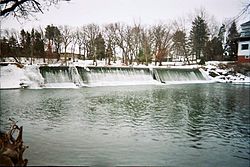
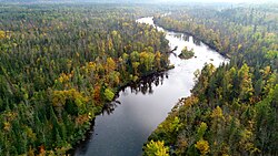
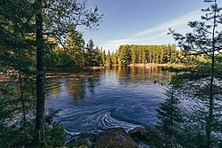
Images of selected Minnesota rivers
 Topographic map of Minnesota streams, lakes and rivers in blue
 Bois de Sioux River below Lake Traverse dam. Roberts County, South Dakota is at left, and Traverse County, Minnesota is at right.


 Cobb River in Blue Earth County
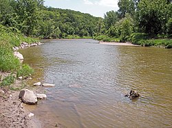

 Embarrass River in Winter
 Le Sueur River near Red Jacket trail
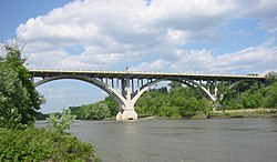 Minnesota River Mendota Heights bridge
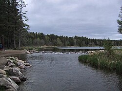 Mississippi River source at Lake Itasca
 Mississippi River and Minnesota River confluence near Fort Snelling State Park
 Mississippi River at St. Anthony Falls in Minneapolis


 Pigeon River High Falls at Grand Portage State Park
 Red River of the North as viewed from Fargo, North Dakota
 St. Croix River viewed in Wisconsin

 Vermilion River in St. Louis County


.jpg)
.jpg)


.jpg)


.jpg)
See also
Wikimedia Commons has media related to Rivers of Minnesota.
Notes
- In North America, the term watershed is commonly used to mean a drainage basin, though in other English-speaking countries, it is used only in its original sense, that of a drainage divide.
- The state is given for non-Minnesota counties
- Length is an average of the 2013 lengths
- The USGS National dataset lists the elevation of the Temperance River as 597 ft (182 m)
- The St. Louis River forms the border between St. Louis County, Minnesota and Douglas County, Wisconsin before it discharges into Lake Superior.
- The USGS National dataset lists the elevation of the St. Louis River as 597 ft (182 m)
- 32.8 miles of the Nemadji River flows through Minnesota.[17]
- The USGS National dataset lists the elevation Nemadji River as 597 ft (182 m)
- The Mississippi River at its source has an elevation of 1,475 ft (450 m)
- The elevation of the Minnesota River is 964 ft (294 m) at its source
- The source elevation of the Red River of the North is 948 ft (289 m)
- According to the Minnesota Department of Natural Resources, 394 mi (634 km) of the Red River of the North are in the United States. This amounts to about 72 percent of the main-stem length.[18][17]
- Wapsipinicon River has a source elevation of 1,348 ft (411 m)
- The Pine River (Mississippi River tributary) should not be confused with the Pine River (Minnesota–Ontario) or Pine River (Saint Louis River tributary), both of which are less than 30 miles long.
Remove ads
References
Wikiwand - on
Seamless Wikipedia browsing. On steroids.
Remove ads