Top Qs
Timeline
Chat
Perspective
List of municipalities in Lycoming County, Pennsylvania
From Wikipedia, the free encyclopedia

Remove ads
There are 52 municipalities in Lycoming County, Pennsylvania. Under Pennsylvania law, counties have three main types of incorporated municipalities, of which Lycoming County has one city, nine boroughs and 42 townships.[1] As of the most recent United States Census (2020), Pennsylvania has 67 counties, which contain 1,547 townships, 955 boroughs (and 2 towns), and 56 cities. There are no unincorporated areas in the county, since all territory in Pennsylvania is incorporated.[1]
The 52 incorporated municipalities in Lycoming County are the subject of the first list, which gives their names and etymologies, dates settled and incorporated, what they were formed from, area, population in 2020, and a map of their location within the county. Twenty other Pennsylvania counties were formed from or contain land originally in Lycoming County.[2] The second list is of the 21 townships which were formerly incorporated in Lycoming County, and now are part of these other counties. It gives the same information as the first list, based on the current status of these townships.
In the 2020 census, the population of Lycoming County was 114,188,[3] making it a "Fifth Class County" (defined by Pennsylvania law as having a population from "90,000 to 144,999").[4] The county seat is Williamsport,[1] and Lycoming County is included in the Williamsport, Pennsylvania metropolitan statistical area.[5] Lycoming County is located in north central Pennsylvania, about 130 miles (210 km) northwest of Philadelphia and 165 miles (266 km) east-northeast of Pittsburgh.[6]
Remove ads
Municipalities
Summarize
Perspective

As of 2024, Lycoming County has 52 incorporated municipalities: one city, nine boroughs, and 42 townships.[1] Townships may contain villages, which the Pennsylvania Department of Transportation (PennDOT) marks with signs and defines as "unincorporated built-up areas which have a post office or a generally recognized name".[7][8] Lycoming County's 42 townships include 96 villages (according to PennDOT), although three of these villages are partly located in neighboring Clinton County.[9] Five of these villages (including one partly in Clinton County)[10][11][12][13][14] are also recognized by the United States Census Bureau as census-designated places (CDPs), which are geographical areas defined for the purposes of compiling demographic data. Neither villages nor CDPs are actual jurisdictions under Pennsylvania law, and their territory is legally part of the incorporated township(s) where they are located.[15] The first list also names the villages and CDPs within their respective townships. Four townships in Lycoming County do not include any villages: Anthony,[16] Clinton,[17] Mifflin,[18] and Porter.[19]
At 1,228.9 square miles (3,183 km2) as of 2023,[20] Lycoming County is the largest county by land area in Pennsylvania.[3] Lycoming County is larger than Rhode Island, the smallest U.S. state, which has a land area of 1,033.9 square miles (2,678 km2).[21] Lycoming County's incorporated municipalities range in size from 0.552 square miles (1.43 km2) (Montgomery borough) to 76.699 square miles (198.65 km2) (McHenry Township).[20] The city of Williamsport has the highest population of any municipality (27,754 or 24.3% of the county total as of 2020), while Brown Township in the northwest corner of the county has the lowest population (93 or 0.081%).[3] Most of the county's population is in the valley along the West Branch Susquehanna River.[a]
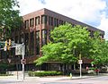 Lycoming County Courthouse, Williamsport


 Dunkard Church, Hepburn Township
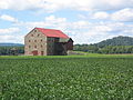 Stone Barn, Fairfield Township


Remove ads
Former townships
Summarize
Perspective

The territory which today makes up Lycoming County was purchased from the Iroquois in two treaties signed at Fort Stanwix in New York: the first treaty was in 1768, and the second treaty was in 1784. The county was formed on April 13, 1795, from part of Northumberland County.[22] The county originally contained seven townships when formed: Lower Bald Eagle, Loyalsock, Lycoming, Muncy, Nippenose, Pine Creek, and Washington. Today Pine Creek is part of Clinton County and Lower Bald Eagle is part of both Centre and Clinton counties, but the rest are still in Lycoming County, although many other municipalities have been formed from these since.[22]
When originally formed in 1795, Lycoming County was "roughly estimated at about 12,000 square miles" (31,000 km2).[22] Its territory stretched north to the New York state line, west to the Allegheny River, south nearly to the source of the West Branch Susquehanna River, and east to include modern Sullivan County and a bit beyond. However, by 1800, just five years after its formation, the first territory was taken from it to form new counties, a process that continued until 1847.[22][2]
Twenty other Pennsylvania counties today contain land that was once part of Lycoming County: five were formed completely from it (Jefferson, McKean, Potter, Tioga, and Sullivan), eight were formed from it and other counties (Armstrong, Bradford, Centre, Clearfield, Clinton, Indiana, Venango, and Warren), three were formed from counties that were themselves formed partly from it (Cameron, Clarion, and Elk), Forest was formed from a county that was formed completely from it (Jefferson), two (Luzerne and Wyoming) contain territory that was part of lycoming County in 1795, and finally Union received a township from it in 1861.[22][2][65] The second table lists each of the twenty one known former incorporated areas in the county, and information on the modern township successors of these today.


 Little Pine Creek Bridge, Cummings Township
 TWA Flight 800 Memorial, Montoursville


Remove ads
Map of municipalities


See also
Notes
- a. ^ The sum of the 2020 US Census populations of all the municipalities that border the West Branch Susquehanna River in Lycoming County is 76,002, or 66.56% of the county's total population. The municipalities bordering the river are: Williamsport (city); Duboistown, Jersey Shore, Montgomery, Montoursville, and South Williamsport (boroughs); and Armstrong, Brady, Clinton, Fairfield, Loyalsock, Muncy, Muncy Creek, Nippenose, Piatt, Porter, Susquehanna, and Woodward (townships).
- b. ^ Northumberland County was formed in 1772 with seven original townships. Only two of the seven (Bald Eagle and Muncy Townships) had land which is now part of Lycoming County. In August 1785, Washington Township was formed from Bald Eagle Township, and in November 1785 parts of Bald Eagle were added to the newly formed Lycoming and Pine Creek townships (the bulk of their territory had been purchased from the Iroquois in 1784). In May 1786, Bald Eagle Township was split into three new townships: Nippenose, Upper Bald Eagle, and Lower Bald Eagle. In 1789, Mifflin County was formed from Upper Bald Eagle Township and half of Potter Township (itself formed partly from the original Bald Eagle Township in May 1774).[22][117]
- When Lycoming County was formed in 1795, Lower Bald Eagle was one of its original seven townships. Centre County was formed in 1800 from parts of Huntingdon, Lycoming, Mifflin, and Northumberland counties. Centre County originally had eight townships, with two (Lower Bald Eagle and Upper Bald Eagle), taken from Lycoming County. It is not clear if this Upper Bald Eagle was a newly formed township, or some portion of the original Northumberland County township not taken when Mifflin County was formed.[118] Some territory from Lower Bald Eagle Township remained in Lycoming County after Centre county was formed.[22]
- In 1801, Centre County renamed "Upper Bald Eagle Township" as "Spring Township" and "Lower Bald Eagle Township" as "Bald Eagle Township". In 1839 Clinton County was formed from Centre and Lycoming counties, with Bald Eagle Township as one of three taken from Centre County. Today neither Centre nor Lycoming counties have a township named "Bald Eagle".[23][66][112]
- c. ^ When Clinton County was formed in 1839, there were 12 original townships. It "embraced the following townships then in Centre County, viz., Bald Eagle, Lamar, and Logan; and from Lycoming, Allison, Chapman, Colebrook, Dunstable, Grove, Lumber, Limestone, Pine Creek, and Wayne."[67] Since Lamar was formed from Bald Eagle, 11 of the 12 original townships came at least indirectly from Lycoming County. Limestone was split from the Lycoming County township of the same name, then attached to Wayne Township, and renamed Crawford Township when it was reformed. Grove and Lumber townships became part of Cameron County, but the remaining ten townships are still in Clinton County.[67]
- Wayne Township is now in Clinton County. According to Meginness (Chapter 14), Wayne was formed from Nippenose Township in 1798, while part of Lycoming County.[22] Note that the PHMC sheet on Clinton County incorrectly says it was formed as part of Northumberland County,[66] but neither the Lycoming nor Northumberland County histories support this.[22][117]
- d. ^ When originally formed in 1803 as part of Lycoming County, Shrewsbury Township encompassed all of what is now Sullivan County. Elkland Township was formed from Shrewsbury in 1804, as were Cherry (1824), Davidson and Forks Townships (both 1833). Plunketts Creek Township was formed from Franklin and Davidson Townships in 1838, and Fox Township was formed from Elkland in 1839. When Sullivan County was formed in 1847 (entirely from Lycoming County), both Shrewsbury and Plunketts Creek Townships were split, with each county originally having a township of that name (Plunketts Creek Township in Sullivan County changed its name to Hillsgrove Township in 1856).[104]
Remove ads
References
External links
Wikiwand - on
Seamless Wikipedia browsing. On steroids.
Remove ads